Chos Malal elevation
Chos Malal (Neuquen, Departamento de Chos-Malal), Argentina elevation is 858 meters and Chos Malal elevation in feet is 2815 ft above sea level [src 1]. Chos Malal is a seat of a second-order administrative division (feature code) with elevation that is 508 meters (1667 ft) bigger than average city elevation in Argentina.
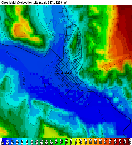
Below is the Elevation map of Chos Malal, which displays elevation range with different colors. Scale of the first map is from 817 to 1258 m (2680 to 4127 ft) with average elevation of 927.6 meters (=3043 ft) [note 1]
These maps also provides idea of topography and contour of this city, they are displayed at different zoom levels. More info about maps, scale and edge coordinates you can find below images.
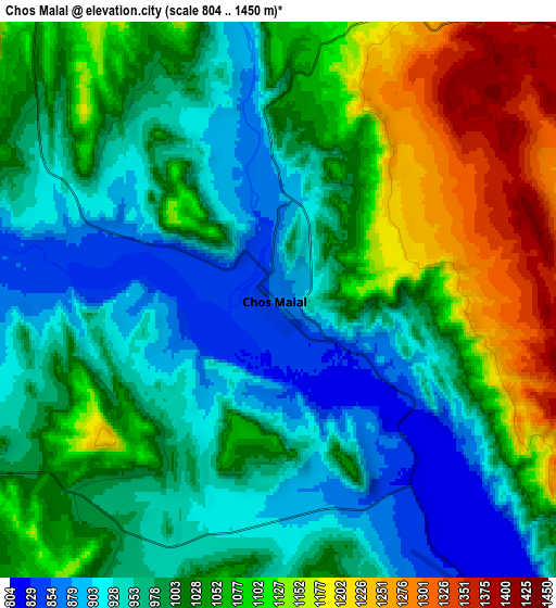
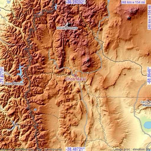
| \ | Map #1 | Map #2 | Topo.Map |
| Scale [m] | 817..1258 m | 804..1450 m | × |
| Scale [ft] | 2680..4127 ft | 2638..4757 ft | × |
| Average | 927.6 m = 3043 ft | 1019.1 m = 3344 ft | × |
| Width | 7.77 km = 4.8 mi | 15.53 km = 9.6 mi | 248.5 km = 154.4 mi |
| Height | 7.77 km = 4.8 mi | 15.53 km = 9.6 mi | 248.5 km = 154.4 mi |
| ↑Max Latitude | -37.343161° | -37.308215° | -36.25232° |
| Latitude at center | -37.37809° | -37.37809° | -37.37809° |
| ↓Min Latitude | -37.413003° | -37.447899° | -38.48721° |
| ← Min Longitude | -70.314795° | -70.358741° | -71.6771° |
| Longitude center | -70.27085° | -70.27085° | -70.27085° |
| →Max Longitude | -70.226905° | -70.182959° | -68.8646° |
Nearby cities:
Cities around Chos Malal sort by population:
• Cutral-Có elevation 613 m
195.5 km,  152°
152°
• Zapala 1015 m
170.2 km,  173°
173°
• Las Lajas 718 m
127.6 km,  183°
183°
• Loncopué 963 m
83 km,  201°
201°
• Andacollo 1096 m
41.6 km,  302°
302°
• Mariano Moreno 773 m
154.1 km, 171°
• Buta Ranquil 1152 m
50.3 km,  43°
43°
• Añelo 403 m
169.5 km,  129°
129°
• El Huecú 1224 m
40.3 km,  222°
222°
• Las Ovejas 1264 m
60.6 km,  315°
315°
• Barrancas 1099 m
69.3 km,  27°
27°
• Rincón de Los Sauces 608 m
118.6 km,  91°
91°
Multilingual:
 En español:
Chos Malal elevación 858 m.
 En France:
Chos Malal élévation 858 m.
 Auf Deutsch:
Chos Malal höhe über dem Meeresspiegel ist 858 m.

Sources and notes:
- [note 1] Map square and city borders are not equal. Map elevation data is calculated only from area inside that square.
- [src 1] Elevation data from geonames database provided with same terms of usage.
- [src 2] The elevation map of Chos Malal is generated using elevation data from NASA's 3 arcsec (90m) resolution SRTM data.
- [src 3] Base (background) map © OpenStreetMap contributors tiles are generated by Geofabrik and OpenTopoMap.
Copyright & License:
This Chos Malal Elevation Map is licensed under CC BY-SA. You may reuse any part from this page, if you give a proper credit by linking to this URL:
 More info on terms of use page.