Añelo elevation
Añelo (Neuquen, Departamento de Añelo), Argentina elevation is 403 meters and Añelo elevation in feet is 1322 ft above sea level [src 1]. Añelo is a seat of a second-order administrative division (feature code) with elevation that is 53 meters (174 ft) bigger than average city elevation in Argentina.
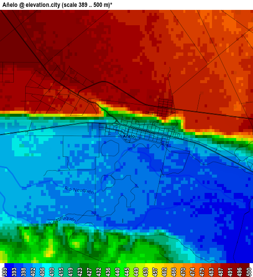
Below is the Elevation map of Añelo, which displays elevation range with different colors. Scale of the first map is from 389 to 500 m (1276 to 1640 ft) with average elevation of 442 meters (=1450 ft) [note 1]
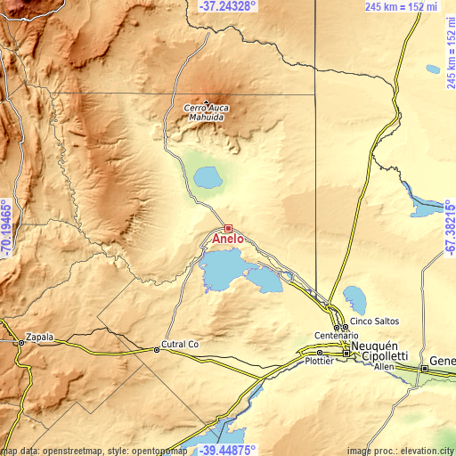
These maps also provides idea of topography and contour of this city, they are displayed at different zoom levels. More info about maps, scale and edge coordinates you can find below images.
| \ | Map #1 | Topo.Map |
| Scale [m] | 389..500 m | × |
| Scale [ft] | 1276..1640 ft | × |
| Average | 442 m = 1450 ft | × |
| Width | 7.66 km = 4.8 mi | 245.2 km = 152.4 mi |
| Height | 7.66 km = 4.8 mi | 245.2 km = 152.4 mi |
| ↑Max Latitude | -38.31994° | -37.24328° |
| Latitude at center | -38.35441° | -38.35441° |
| ↓Min Latitude | -38.388863° | -39.44875° |
| ← Min Longitude | -68.832345° | -70.19465° |
| Longitude center | -68.7884° | -68.7884° |
| →Max Longitude | -68.744455° | -67.38215° |
Nearby cities:
Cities around Añelo sort by population:
• Neuquén elevation 281 m
91.8 km,  136°
136°
• Cipolletti 267 m
94.6 km,  132°
132°
• Cutral-Có 613 m
75 km,  210°
210°
• Centenario 292 m
77.8 km, 132°
• Plottier 279 m
83.4 km, 144°
• Cinco Saltos 288 m
81.7 km, 129°
• Catriel 323 m
101.7 km,  58°
58°
• Plaza Huincul 600 m
73.3 km, 209°
• General Fernández Oro 258 m
100.3 km, 131°
• Senillosa 294 m
79.6 km,  157°
157°
• Vista Alegre 336 m
68.6 km, 129°
• Contraalmirante Cordero 303 m
68.9 km, 126°
Multilingual:
 En español:
Añelo elevación 403 m.
 En France:
Añelo élévation 403 m.


Sources and notes:
- [note 1] Map square and city borders are not equal. Map elevation data is calculated only from area inside that square.
- [src 1] Elevation data from geonames database provided with same terms of usage.
- [src 2] The elevation map of Añelo is generated using elevation data from NASA's 3 arcsec (90m) resolution SRTM data.
- [src 3] Base (background) map © OpenStreetMap contributors tiles are generated by Geofabrik and OpenTopoMap.
Copyright & License:
This Añelo Elevation Map is licensed under CC BY-SA. You may reuse any part from this page, if you give a proper credit by linking to this URL:
 More info on terms of use page.