Catriel elevation
Catriel (Rio Negro, Departamento de General Roca), Argentina elevation is 323 meters and Catriel elevation in feet is 1060 ft above sea level [src 1]. Catriel is a populated place (feature code) with elevation that is 27 meters (89 ft) smaller than average city elevation in Argentina.
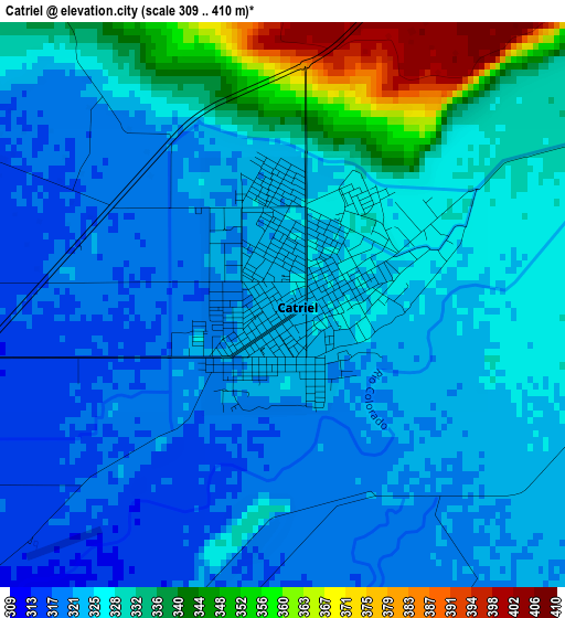
Below is the Elevation map of Catriel, which displays elevation range with different colors. Scale of the first map is from 309 to 410 m (1014 to 1345 ft) with average elevation of 327.2 meters (=1073 ft) [note 1]
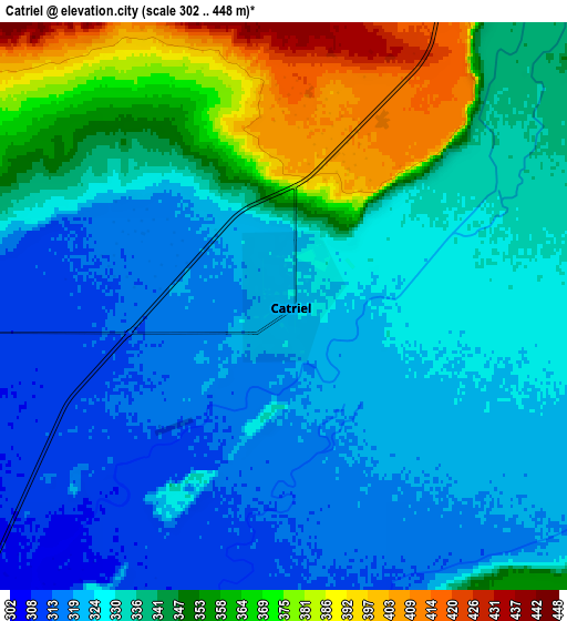
These maps also provides idea of topography and contour of this city, they are displayed at different zoom levels. More info about maps, scale and edge coordinates you can find below images.
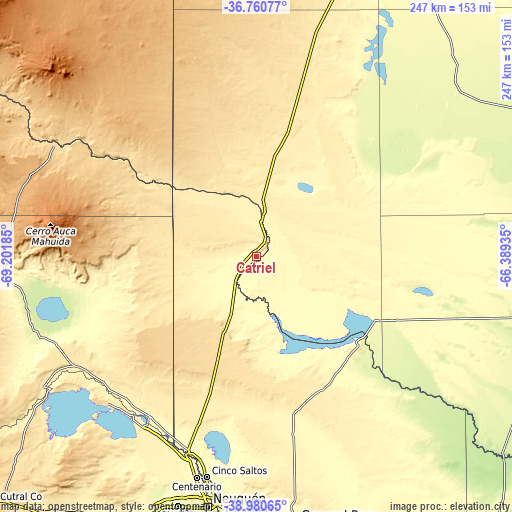
| \ | Map #1 | Map #2 | Topo.Map |
| Scale [m] | 309..410 m | 302..448 m | × |
| Scale [ft] | 1014..1345 ft | 991..1470 ft | × |
| Average | 327.2 m = 1073 ft | 337.2 m = 1106 ft | × |
| Width | 7.71 km = 4.8 mi | 15.43 km = 9.6 mi | 246.8 km = 153.4 mi |
| Height | 7.71 km = 4.8 mi | 15.43 km = 9.6 mi | 246.8 km = 153.4 mi |
| ↑Max Latitude | -37.844375° | -37.809665° | -36.76077° |
| Latitude at center | -37.87907° | -37.87907° | -37.87907° |
| ↓Min Latitude | -37.913748° | -37.94841° | -38.98065° |
| ← Min Longitude | -67.839545° | -67.883491° | -69.20185° |
| Longitude center | -67.7956° | -67.7956° | -67.7956° |
| →Max Longitude | -67.751655° | -67.707709° | -66.38935° |
Nearby cities:
Cities around Catriel sort by population:
• Neuquén elevation 281 m
121.4 km,  190°
190°
• Cipolletti 267 m
118.5 km, 188°
• Centenario 292 m
109.7 km,  195°
195°
• Allen 258 m
122.1 km,  181°
181°
• Plottier 279 m
126.8 km, 197°
• Cinco Saltos 288 m
107.4 km, 192°
• Veinticinco de Mayo 348 m
13.6 km,  30°
30°
• General Fernández Oro 258 m
119.9 km, 185°
• Vista Alegre 336 m
102.6 km, 199°
• Contraalmirante Cordero 303 m
99 km, 198°
• Añelo 403 m
101.7 km,  238°
238°
• Rincón de Los Sauces 608 m
113.2 km,  298°
298°
Multilingual:
 En español:
Catriel elevación 323 m.
 En France:
Catriel élévation 323 m.


Sources and notes:
- [note 1] Map square and city borders are not equal. Map elevation data is calculated only from area inside that square.
- [src 1] Elevation data from geonames database provided with same terms of usage.
- [src 2] The elevation map of Catriel is generated using elevation data from NASA's 3 arcsec (90m) resolution SRTM data.
- [src 3] Base (background) map © OpenStreetMap contributors tiles are generated by Geofabrik and OpenTopoMap.
Copyright & License:
This Catriel Elevation Map is licensed under CC BY-SA. You may reuse any part from this page, if you give a proper credit by linking to this URL:
 More info on terms of use page.