General Enrique Godoy elevation
General Enrique Godoy (Rio Negro, Departamento de General Roca), Argentina elevation is 209 meters and General Enrique Godoy elevation in feet is 686 ft above sea level [src 1]. General Enrique Godoy is a populated place (feature code) with elevation that is 141 meters (463 ft) smaller than average city elevation in Argentina.
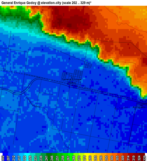
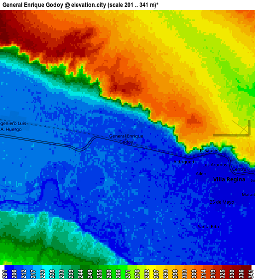
Below is the Elevation map of General Enrique Godoy, which displays elevation range with different colors. Scale of the first map is from 202 to 329 m (663 to 1079 ft) with average elevation of 235.4 meters (=772 ft) [note 1]
These maps also provides idea of topography and contour of this city, they are displayed at different zoom levels. More info about maps, scale and edge coordinates you can find below images.
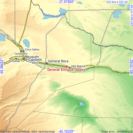
| \ | Map #1 | Map #2 | Topo.Map |
| Scale [m] | 202..329 m | 201..341 m | × |
| Scale [ft] | 663..1079 ft | 659..1119 ft | × |
| Average | 235.4 m = 772 ft | 246 m = 807 ft | × |
| Width | 7.59 km = 4.7 mi | 15.17 km = 9.4 mi | 242.8 km = 150.9 mi |
| Height | 7.59 km = 4.7 mi | 15.17 km = 9.4 mi | 242.7 km = 150.8 mi |
| ↑Max Latitude | -39.044788° | -39.010649° | -37.97885° |
| Latitude at center | -39.07891° | -39.07891° | -39.07891° |
| ↓Min Latitude | -39.113016° | -39.147105° | -40.16209° |
| ← Min Longitude | -67.202015° | -67.245961° | -68.56432° |
| Longitude center | -67.15807° | -67.15807° | -67.15807° |
| →Max Longitude | -67.114125° | -67.070179° | -65.75182° |
Nearby cities:
Cities around General Enrique Godoy sort by population:
• Neuquén elevation 281 m
79.1 km,  280°
280°
• Cipolletti 267 m
73.7 km, 282°
• General Roca 237 m
37.1 km, 277°
• Villa Regina 201 m
8.2 km,  106°
106°
• Allen 258 m
58.9 km, 281°
• Cinco Saltos 288 m
83.3 km,  290°
290°
• General Fernández Oro 258 m
67.7 km, 281°
• Ingeniero Luis A. Huergo 215 m
6.9 km, 276°
• Cervantes 222 m
20.6 km, 277°
• Chichinales 197 m
20.3 km,  101°
101°
• Chimpay 158 m
88.1 km, 96°
• Mainque 218 m
12.3 km, 276°
Multilingual:
 En español:
General Enrique Godoy elevación 209 m.
 En France:
General Enrique Godoy élévation 209 m.
 Auf Deutsch:
General Enrique Godoy höhe über dem Meeresspiegel ist 209 m.
 На русском:
General Enrique Godoy высота над уровнем моря 209 м
Sources and notes:
- [note 1] Map square and city borders are not equal. Map elevation data is calculated only from area inside that square.
- [src 1] Elevation data from geonames database provided with same terms of usage.
- [src 2] The elevation map of General Enrique Godoy is generated using elevation data from NASA's 3 arcsec (90m) resolution SRTM data.
- [src 3] Base (background) map © OpenStreetMap contributors tiles are generated by Geofabrik and OpenTopoMap.
Copyright & License:
This General Enrique Godoy Elevation Map is licensed under CC BY-SA. You may reuse any part from this page, if you give a proper credit by linking to this URL:
 More info on terms of use page.