Chimpay elevation
Chimpay (Rio Negro, Departamento de Avellaneda), Argentina elevation is 158 meters and Chimpay elevation in feet is 518 ft above sea level [src 1]. Chimpay is a populated place (feature code) with elevation that is 192 meters (630 ft) smaller than average city elevation in Argentina.
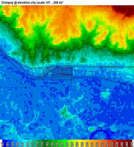
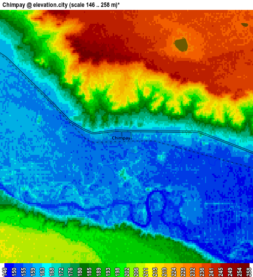
Below is the Elevation map of Chimpay, which displays elevation range with different colors. Scale of the first map is from 147 to 248 m (482 to 814 ft) with average elevation of 173.8 meters (=570 ft) [note 1]
These maps also provides idea of topography and contour of this city, they are displayed at different zoom levels. More info about maps, scale and edge coordinates you can find below images.
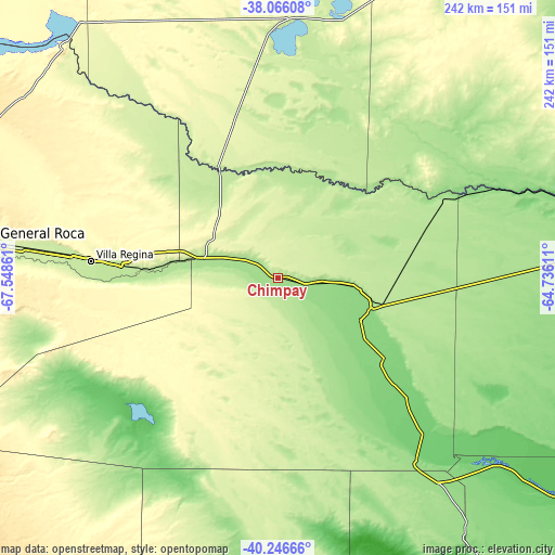
| \ | Map #1 | Map #2 | Topo.Map |
| Scale [m] | 147..248 m | 146..258 m | × |
| Scale [ft] | 482..814 ft | 479..846 ft | × |
| Average | 173.8 m = 570 ft | 187.1 m = 614 ft | × |
| Width | 7.58 km = 4.7 mi | 15.15 km = 9.4 mi | 242.5 km = 150.7 mi |
| Height | 7.58 km = 4.7 mi | 15.15 km = 9.4 mi | 242.5 km = 150.7 mi |
| ↑Max Latitude | -39.13074° | -39.096643° | -38.06608° |
| Latitude at center | -39.16482° | -39.16482° | -39.16482° |
| ↓Min Latitude | -39.198884° | -39.232931° | -40.24666° |
| ← Min Longitude | -66.186305° | -66.230251° | -67.54861° |
| Longitude center | -66.14236° | -66.14236° | -66.14236° |
| →Max Longitude | -66.098415° | -66.054469° | -64.73611° |
Nearby cities:
Cities around Chimpay sort by population:
• Villa Regina elevation 201 m
80 km,  275°
275°
• Choele Choel 131 m
43.7 km,  108°
108°
• Lamarque 128 m
47.5 km,  127°
127°
• Ingeniero Luis A. Huergo 215 m
95.1 km, 276°
• Fray Luis Beltrán 135 m
36.9 km,  116°
116°
• Cervantes 222 m
108.7 km, 276°
• Chichinales 197 m
67.9 km,  274°
274°
• General Enrique Godoy 209 m
88.1 km, 276°
• Mainque 218 m
100.5 km, 276°
• Coronel Belisle 156 m
16.4 km,  98°
98°
• Darwin 137 m
35 km, 97°
• Puelches 235 m
115 km,  9°
9°
Multilingual:
 En español:
Chimpay elevación 158 m.
 En France:
Chimpay élévation 158 m.


Sources and notes:
- [note 1] Map square and city borders are not equal. Map elevation data is calculated only from area inside that square.
- [src 1] Elevation data from geonames database provided with same terms of usage.
- [src 2] The elevation map of Chimpay is generated using elevation data from NASA's 3 arcsec (90m) resolution SRTM data.
- [src 3] Base (background) map © OpenStreetMap contributors tiles are generated by Geofabrik and OpenTopoMap.
Copyright & License:
This Chimpay Elevation Map is licensed under CC BY-SA. You may reuse any part from this page, if you give a proper credit by linking to this URL:
 More info on terms of use page.