Santa Rosa de Río Primero elevation
Santa Rosa de Río Primero (Cordoba, Departamento de Río Primero), Argentina elevation is 171 meters and Santa Rosa de Río Primero elevation in feet is 561 ft above sea level [src 1]. Santa Rosa de Río Primero is a seat of a second-order administrative division (feature code) with elevation that is 179 meters (587 ft) smaller than average city elevation in Argentina.
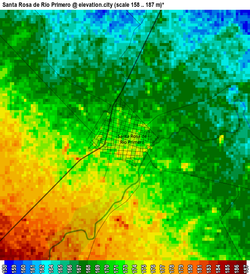
Below is the Elevation map of Santa Rosa de Río Primero, which displays elevation range with different colors. Scale of the first map is from 158 to 187 m (518 to 614 ft) with average elevation of 170.4 meters (=559 ft) [note 1]
These maps also provides idea of topography and contour of this city, they are displayed at different zoom levels. More info about maps, scale and edge coordinates you can find below images.

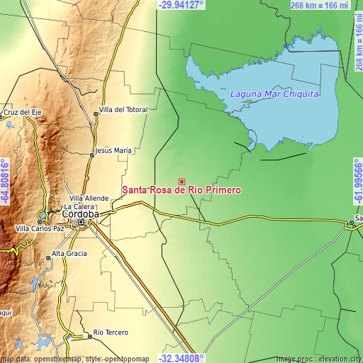
| \ | Map #1 | Map #2 | Topo.Map |
| Scale [m] | 158..187 m | 145..202 m | × |
| Scale [ft] | 518..614 ft | 476..663 ft | × |
| Average | 170.4 m = 559 ft | 169.6 m = 556 ft | × |
| Width | 8.36 km = 5.2 mi | 16.73 km = 10.4 mi | 267.6 km = 166.3 mi |
| Height | 8.36 km = 5.2 mi | 16.73 km = 10.4 mi | 267.6 km = 166.3 mi |
| ↑Max Latitude | -31.114694° | -31.077064° | -29.94127° |
| Latitude at center | -31.15231° | -31.15231° | -31.15231° |
| ↓Min Latitude | -31.189911° | -31.227497° | -32.34808° |
| ← Min Longitude | -63.445855° | -63.489801° | -64.80816° |
| Longitude center | -63.40191° | -63.40191° | -63.40191° |
| →Max Longitude | -63.357965° | -63.314019° | -61.99566° |
Nearby cities:
Cities around Santa Rosa de Río Primero sort by population:
• Arroyito elevation 154 m
44.8 km,  131°
131°
• Villa del Totoral 233 m
47.9 km,  321°
321°
• Monte Cristo 350 m
55.8 km,  247°
247°
• La Para 93 m
47.8 km,  53°
53°
• Santiago Temple 215 m
26.2 km,  183°
183°
• Obispo Trejo 103 m
41.3 km,  358°
358°
• Marull 93 m
57.6 km,  72°
72°
• Villa Concepción del Tío 125 m
59.1 km,  108°
108°
• Piquillín 285 m
37.7 km,  243°
243°
• Colonia La Tordilla 141 m
33.7 km, 106°
• Cañada de Luque 239 m
55.8 km,  326°
326°
• Villa del Rosario 249 m
46.7 km,  195°
195°
Multilingual:
 En español:
Santa Rosa de Río Primero elevación 171 m.
 En France:
Santa Rosa de Río Primero élévation 171 m.
 Auf Deutsch:
Santa Rosa de Río Primero höhe über dem Meeresspiegel ist 171 m.
 На русском:
Santa Rosa de Río Primero высота над уровнем моря 171 м
Sources and notes:
- [note 1] Map square and city borders are not equal. Map elevation data is calculated only from area inside that square.
- [src 1] Elevation data from geonames database provided with same terms of usage.
- [src 2] The elevation map of Santa Rosa de Río Primero is generated using elevation data from NASA's 3 arcsec (90m) resolution SRTM data.
- [src 3] Base (background) map © OpenStreetMap contributors tiles are generated by Geofabrik and OpenTopoMap.
Copyright & License:
This Santa Rosa de Río Primero Elevation Map is licensed under CC BY-SA. You may reuse any part from this page, if you give a proper credit by linking to this URL:
 More info on terms of use page.