Arroyito elevation
Arroyito (Cordoba, Departamento de San Justo), Argentina elevation is 154 meters and Arroyito elevation in feet is 505 ft above sea level [src 1]. Arroyito is a populated place (feature code) with elevation that is 196 meters (643 ft) smaller than average city elevation in Argentina.
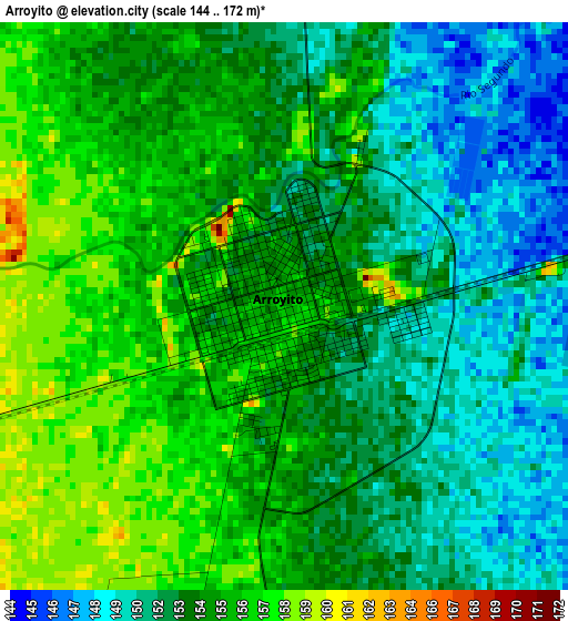
Below is the Elevation map of Arroyito, which displays elevation range with different colors. Scale of the first map is from 144 to 172 m (472 to 564 ft) with average elevation of 153.5 meters (=504 ft) [note 1]
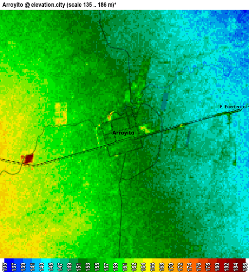
These maps also provides idea of topography and contour of this city, they are displayed at different zoom levels. More info about maps, scale and edge coordinates you can find below images.
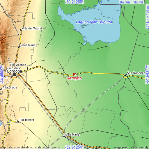
| \ | Map #1 | Map #2 | Topo.Map |
| Scale [m] | 144..172 m | 135..186 m | × |
| Scale [ft] | 472..564 ft | 443..610 ft | × |
| Average | 153.5 m = 504 ft | 153.1 m = 502 ft | × |
| Width | 8.34 km = 5.2 mi | 16.68 km = 10.4 mi | 266.9 km = 165.8 mi |
| Height | 8.34 km = 5.2 mi | 16.68 km = 10.4 mi | 266.9 km = 165.8 mi |
| ↑Max Latitude | -31.382711° | -31.345187° | -30.21255° |
| Latitude at center | -31.42022° | -31.42022° | -31.42022° |
| ↓Min Latitude | -31.457714° | -31.495193° | -32.61254° |
| ← Min Longitude | -63.093965° | -63.137911° | -64.45627° |
| Longitude center | -63.05002° | -63.05002° | -63.05002° |
| →Max Longitude | -63.006075° | -62.962129° | -61.64377° |
Nearby cities:
Cities around Arroyito sort by population:
• Santa Rosa de Río Primero elevation 171 m
44.8 km,  311°
311°
• La Francia 112 m
39.5 km,  87°
87°
• Sacanta 166 m
27 km,  179°
179°
• Santiago Temple 215 m
35.1 km,  275°
275°
• Marull 93 m
51.9 km,  24°
24°
• Villa Concepción del Tío 125 m
24.9 km,  64°
64°
• Carrilobo 185 m
50.7 km,  187°
187°
• El Tío 126 m
21.3 km,  78°
78°
• El Arañado 150 m
38.7 km,  157°
157°
• Colonia La Tordilla 141 m
20.3 km,  356°
356°
• Colonia San Bartolomé 125 m
33.1 km,  111°
111°
• Villa del Rosario 249 m
48.4 km,  251°
251°
Multilingual:
 En español:
Arroyito elevación 154 m.
 En France:
Arroyito élévation 154 m.
 Auf Deutsch:
Arroyito höhe über dem Meeresspiegel ist 154 m.

Sources and notes:
- [note 1] Map square and city borders are not equal. Map elevation data is calculated only from area inside that square.
- [src 1] Elevation data from geonames database provided with same terms of usage.
- [src 2] The elevation map of Arroyito is generated using elevation data from NASA's 3 arcsec (90m) resolution SRTM data.
- [src 3] Base (background) map © OpenStreetMap contributors tiles are generated by Geofabrik and OpenTopoMap.
Copyright & License:
This Arroyito Elevation Map is licensed under CC BY-SA. You may reuse any part from this page, if you give a proper credit by linking to this URL:
 More info on terms of use page.