Obispo Trejo elevation
Obispo Trejo (Cordoba, Departamento de Río Primero), Argentina elevation is 103 meters and Obispo Trejo elevation in feet is 338 ft above sea level [src 1]. Obispo Trejo is a populated place (feature code) with elevation that is 247 meters (810 ft) smaller than average city elevation in Argentina.
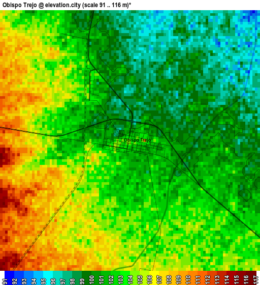
Below is the Elevation map of Obispo Trejo, which displays elevation range with different colors. Scale of the first map is from 91 to 116 m (299 to 381 ft) with average elevation of 102.3 meters (=336 ft) [note 1]
These maps also provides idea of topography and contour of this city, they are displayed at different zoom levels. More info about maps, scale and edge coordinates you can find below images.
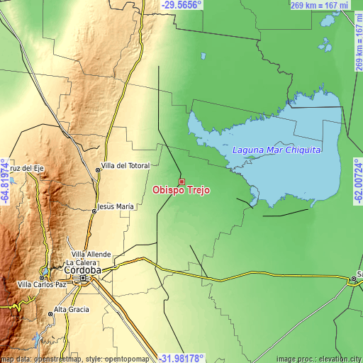
| \ | Map #1 | Topo.Map |
| Scale [m] | 91..116 m | × |
| Scale [ft] | 299..381 ft | × |
| Average | 102.3 m = 336 ft | × |
| Width | 8.4 km = 5.2 mi | 268.7 km = 167 mi |
| Height | 8.4 km = 5.2 mi | 268.7 km = 167 mi |
| ↑Max Latitude | -30.743518° | -29.5656° |
| Latitude at center | -30.78128° | -30.78128° |
| ↓Min Latitude | -30.819027° | -31.98178° |
| ← Min Longitude | -63.457435° | -64.81974° |
| Longitude center | -63.41349° | -63.41349° |
| →Max Longitude | -63.369545° | -62.00724° |
Nearby cities:
Cities around Obispo Trejo sort by population:
• Jesús María elevation 533 m
68.7 km,  251°
251°
• Villa del Totoral 233 m
29.2 km,  262°
262°
• Santa Rosa de Río Primero 171 m
41.3 km,  178°
178°
• San José de la Dormida 468 m
69.8 km,  312°
312°
• La Para 93 m
41.3 km,  107°
107°
• Santiago Temple 215 m
67.4 km, 180°
• Sebastián Elcano 211 m
71.1 km,  345°
345°
• Miramar 78 m
71.8 km,  102°
102°
• Marull 93 m
60.9 km, 112°
• Piquillín 285 m
66.5 km,  209°
209°
• Colonia La Tordilla 141 m
60.8 km,  146°
146°
• Cañada de Luque 239 m
30.1 km,  280°
280°
Multilingual:
 En español:
Obispo Trejo elevación 103 m.
 En France:
Obispo Trejo élévation 103 m.
 Auf Deutsch:
Obispo Trejo höhe über dem Meeresspiegel ist 103 m.

Sources and notes:
- [note 1] Map square and city borders are not equal. Map elevation data is calculated only from area inside that square.
- [src 1] Elevation data from geonames database provided with same terms of usage.
- [src 2] The elevation map of Obispo Trejo is generated using elevation data from NASA's 3 arcsec (90m) resolution SRTM data.
- [src 3] Base (background) map © OpenStreetMap contributors tiles are generated by Geofabrik and OpenTopoMap.
Copyright & License:
This Obispo Trejo Elevation Map is licensed under CC BY-SA. You may reuse any part from this page, if you give a proper credit by linking to this URL:
 More info on terms of use page.