Chambarak elevation
Chambarak (Gegharkunik), Armenia elevation is 1848 meters and Chambarak elevation in feet is 6063 ft above sea level [src 1]. Chambarak is a populated place (feature code) with elevation that is 550 meters (1804 ft) bigger than average city elevation in Armenia.
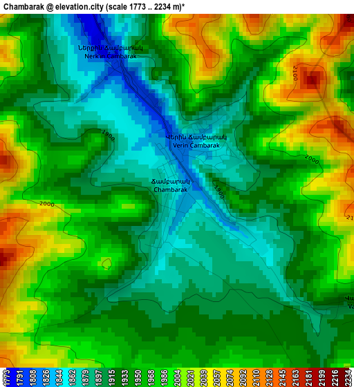
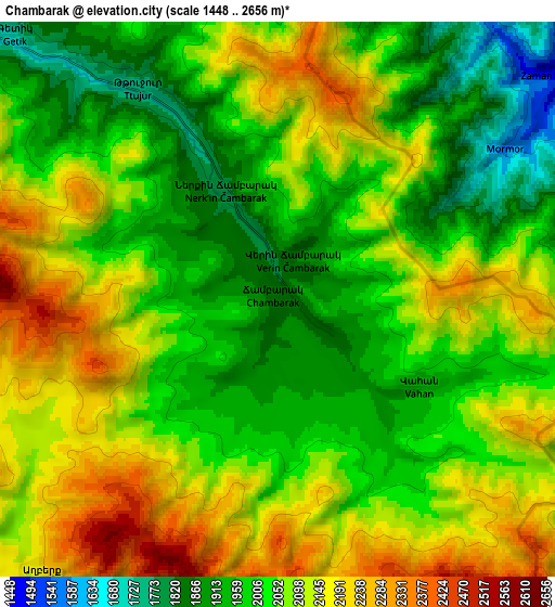
Below is the Elevation map of Chambarak, which displays elevation range with different colors. Scale of the first map is from 1773 to 2234 m (5817 to 7329 ft) with average elevation of 1948.9 meters (=6394 ft) [note 1]
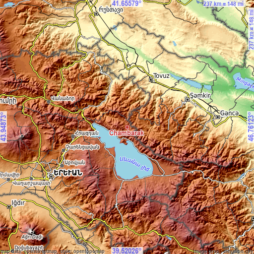
These maps also provides idea of topography and contour of this city, they are displayed at different zoom levels. More info about maps, scale and edge coordinates you can find below images.
| \ | Map #1 | Map #2 | Topo.Map |
| Scale [m] | 1773..2234 m | 1448..2656 m | × |
| Scale [ft] | 5817..7329 ft | 4751..8714 ft | × |
| Average | 1948.9 m = 6394 ft | 2055.2 m = 6743 ft | × |
| Width | 7.42 km = 4.6 mi | 14.84 km = 9.2 mi | 237.4 km = 147.5 mi |
| Height | 7.42 km = 4.6 mi | 14.84 km = 9.2 mi | 237.4 km = 147.5 mi |
| ↑Max Latitude | 40.62991° | 40.663253° | 41.65579° |
| Latitude at center | 40.59655° | 40.59655° | 40.59655° |
| ↓Min Latitude | 40.563174° | 40.52978° | 39.52026° |
| ← Min Longitude | 45.311035° | 45.267089° | 43.94873° |
| Longitude center | 45.35498° | 45.35498° | 45.35498° |
| →Max Longitude | 45.398925° | 45.442871° | 46.76123° |
Nearby cities:
Cities around Chambarak sort by population:
• Gavarr elevation 1953 m
33.3 km,  215°
215°
• Sevan 1934 m
35.3 km,  261°
261°
• Ijevan 677 m
35.9 km,  330°
330°
• Berd 949 m
31.8 km,  5°
5°
• Noratus 1926 m
28.4 km,  211°
211°
• Tsovagyugh 2016 m
33.5 km,  277°
277°
• Artsvaberd 1285 m
28.7 km,  19°
19°
• Tsovazard 1944 m
29.1 km,  242°
242°
• Navur 1482 m
30.1 km,  357°
357°
• Vahan 1925 m
4.3 km,  122°
122°
• Lchap’ 1931 m
28.4 km, 236°
• Drakhtik 1983 m
10.6 km,  250°
250°
Multilingual:
 En español:
Chambarak elevación 1848 m.
 En France:
Chambarak élévation 1848 m.
 Auf Deutsch:
Chambarak höhe über dem Meeresspiegel ist 1848 m.

Sources and notes:
- [note 1] Map square and city borders are not equal. Map elevation data is calculated only from area inside that square.
- [src 1] Elevation data from geonames database provided with same terms of usage.
- [src 2] The elevation map of Chambarak is generated using elevation data from NASA's 3 arcsec (90m) resolution SRTM data.
- [src 3] Base (background) map © OpenStreetMap contributors tiles are generated by Geofabrik and OpenTopoMap.
Copyright & License:
This Chambarak Elevation Map is licensed under CC BY-SA. You may reuse any part from this page, if you give a proper credit by linking to this URL:
 More info on terms of use page.