Ijevan elevation
Ijevan (Tavush), Armenia elevation is 677 meters and Ijevan elevation in feet is 2221 ft above sea level [src 1]. Ijevan is a seat of a first-order administrative division (feature code) with elevation that is 621 meters (2037 ft) smaller than average city elevation in Armenia.
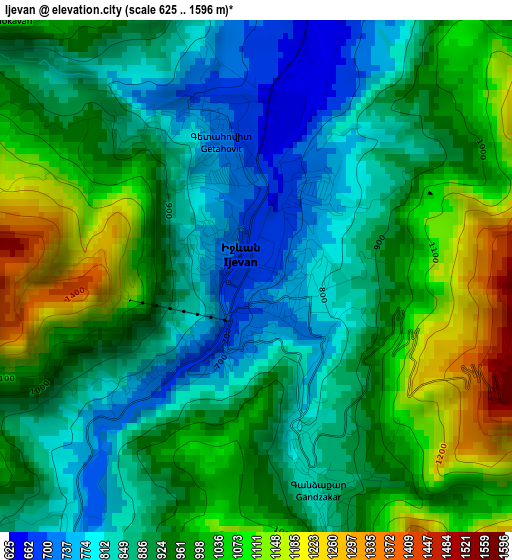
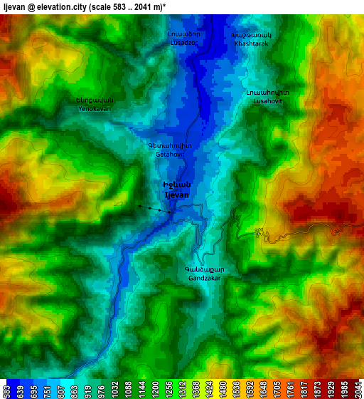
Below is the Elevation map of Ijevan, which displays elevation range with different colors. Scale of the first map is from 625 to 1596 m (2051 to 5236 ft) with average elevation of 939.6 meters (=3083 ft) [note 1]
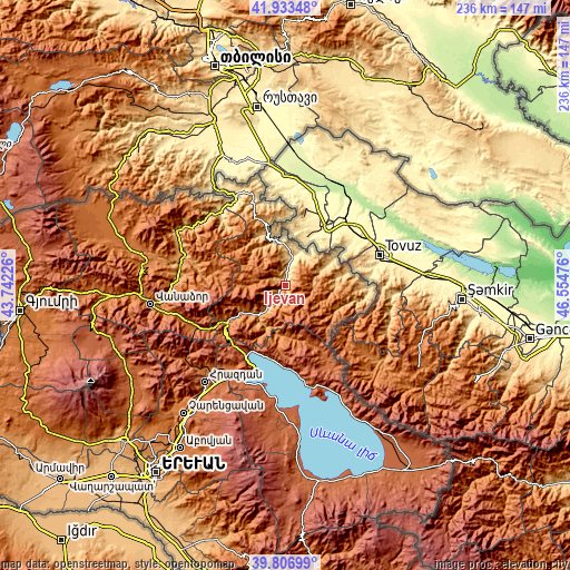
These maps also provides idea of topography and contour of this city, they are displayed at different zoom levels. More info about maps, scale and edge coordinates you can find below images.
| \ | Map #1 | Map #2 | Topo.Map |
| Scale [m] | 625..1596 m | 583..2041 m | × |
| Scale [ft] | 2051..5236 ft | 1913..6696 ft | × |
| Average | 939.6 m = 3083 ft | 1205.5 m = 3955 ft | × |
| Width | 7.39 km = 4.6 mi | 14.78 km = 9.2 mi | 236.4 km = 146.9 mi |
| Height | 7.39 km = 4.6 mi | 14.78 km = 9.2 mi | 236.4 km = 146.9 mi |
| ↑Max Latitude | 40.911989° | 40.94519° | 41.93348° |
| Latitude at center | 40.87877° | 40.87877° | 40.87877° |
| ↓Min Latitude | 40.845535° | 40.812283° | 39.80699° |
| ← Min Longitude | 45.104565° | 45.060619° | 43.74226° |
| Longitude center | 45.14851° | 45.14851° | 45.14851° |
| →Max Longitude | 45.192455° | 45.236401° | 46.55476° |
Nearby cities:
Cities around Ijevan sort by population:
• Dilijan elevation 1315 m
29.4 km,  238°
238°
• Berd 949 m
20.2 km,  89°
89°
• Haghartsin 1015 m
19 km,  233°
233°
• Artsvaberd 1285 m
27.4 km,  99°
99°
• Aygehovit 697 m
14.1 km,  37°
37°
• Mosesgegh 817 m
28.7 km,  84°
84°
• Azatamut 547 m
11.9 km,  15°
15°
• Khasht’arrak 816 m
7 km, 23°
• Parravak’ar 768 m
21.7 km,  57°
57°
• Voskevan 946 m
27.8 km,  345°
345°
• Navur 1482 m
16.3 km, 94°
• Sarigyugh 828 m
17.4 km,  358°
358°
Multilingual:
 En español:
Ijevan elevación 677 m.
 En France:
Idjevan élévation 677 m.
 Auf Deutsch:
Idschewan höhe über dem Meeresspiegel ist 677 m.

Sources and notes:
- [note 1] Map square and city borders are not equal. Map elevation data is calculated only from area inside that square.
- [src 1] Elevation data from geonames database provided with same terms of usage.
- [src 2] The elevation map of Ijevan is generated using elevation data from NASA's 3 arcsec (90m) resolution SRTM data.
- [src 3] Base (background) map © OpenStreetMap contributors tiles are generated by Geofabrik and OpenTopoMap.
Copyright & License:
This Ijevan Elevation Map is licensed under CC BY-SA. You may reuse any part from this page, if you give a proper credit by linking to this URL:
 More info on terms of use page.