Gavarr elevation
Gavarr (Gegharkunik), Armenia elevation is 1953 meters and Gavarr elevation in feet is 6407 ft above sea level [src 1]. Gavarr is a seat of a first-order administrative division (feature code) with elevation that is 655 meters (2149 ft) bigger than average city elevation in Armenia.
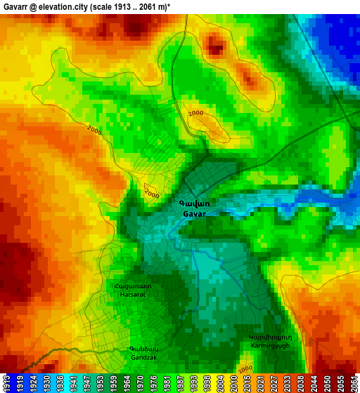
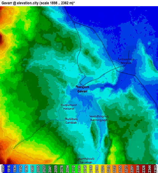
Below is the Elevation map of Gavarr, which displays elevation range with different colors. Scale of the first map is from 1913 to 2061 m (6276 to 6762 ft) with average elevation of 1989.4 meters (=6527 ft) [note 1]
These maps also provides idea of topography and contour of this city, they are displayed at different zoom levels. More info about maps, scale and edge coordinates you can find below images.
| \ | Map #1 | Map #2 | Topo.Map |
| Scale [m] | 1913..2061 m | 1898..2362 m | × |
| Scale [ft] | 6276..6762 ft | 6227..7749 ft | × |
| Average | 1989.4 m = 6527 ft | 2022.4 m = 6635 ft | × |
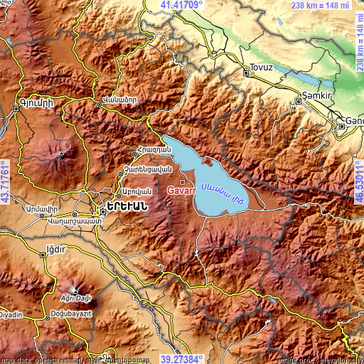
| Width | 7.45 km = 4.6 mi | 14.89 km = 9.3 mi | 238.3 km = 148.1 mi |
| Height | 7.45 km = 4.6 mi | 14.89 km = 9.3 mi | 238.3 km = 148.1 mi |
| ↑Max Latitude | 40.387461° | 40.420925° | 41.41709° |
| Latitude at center | 40.35398° | 40.35398° | 40.35398° |
| ↓Min Latitude | 40.320483° | 40.286969° | 39.27384° |
| ← Min Longitude | 45.079915° | 45.035969° | 43.71761° |
| Longitude center | 45.12386° | 45.12386° | 45.12386° |
| →Max Longitude | 45.167805° | 45.211751° | 46.53011° |
Nearby cities:
Cities around Gavarr sort by population:
• Sarukhan elevation 1990 m
7 km,  175°
175°
• Noratus 1926 m
5.5 km,  60°
60°
• Yeranos 1982 m
17.6 km,  160°
160°
• Lchashen 1929 m
24.6 km,  318°
318°
• Lichk’ 1930 m
23.6 km, 156°
• Gandzak 1989 m
4.5 km,  193°
193°
• Dzoragyugh 2016 m
21.1 km,  166°
166°
• Tsovasar 2100 m
24.7 km, 166°
• Lanjaghbyur 2042 m
9.6 km, 169°
• Vardadzor 1997 m
19.4 km, 162°
• Tsovazard 1944 m
14.8 km,  335°
335°
• Lchap’ 1931 m
12 km, 339°
Multilingual:
 En español:
Gavarr elevación 1953 m.
 En France:
Gavarr élévation 1953 m.


Sources and notes:
- [note 1] Map square and city borders are not equal. Map elevation data is calculated only from area inside that square.
- [src 1] Elevation data from geonames database provided with same terms of usage.
- [src 2] The elevation map of Gavarr is generated using elevation data from NASA's 3 arcsec (90m) resolution SRTM data.
- [src 3] Base (background) map © OpenStreetMap contributors tiles are generated by Geofabrik and OpenTopoMap.
Copyright & License:
This Gavarr Elevation Map is licensed under CC BY-SA. You may reuse any part from this page, if you give a proper credit by linking to this URL:
 More info on terms of use page.