Noratus elevation
Noratus (Gegharkunik), Armenia elevation is 1926 meters and Noratus elevation in feet is 6319 ft above sea level [src 1]. Noratus is a populated place (feature code) with elevation that is 628 meters (2060 ft) bigger than average city elevation in Armenia.
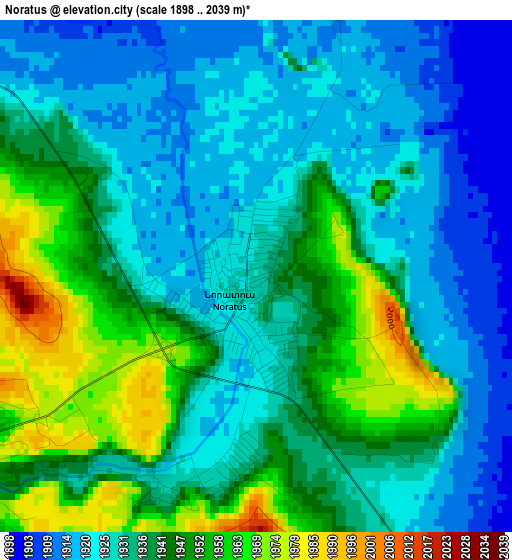
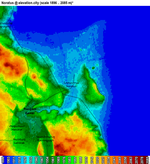
Below is the Elevation map of Noratus, which displays elevation range with different colors. Scale of the first map is from 1898 to 2039 m (6227 to 6690 ft) with average elevation of 1935.5 meters (=6350 ft) [note 1]
These maps also provides idea of topography and contour of this city, they are displayed at different zoom levels. More info about maps, scale and edge coordinates you can find below images.
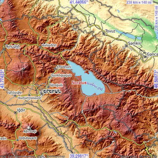
| \ | Map #1 | Map #2 | Topo.Map |
| Scale [m] | 1898..2039 m | 1896..2085 m | × |
| Scale [ft] | 6227..6690 ft | 6220..6841 ft | × |
| Average | 1935.5 m = 6350 ft | 1938.1 m = 6359 ft | × |
| Width | 7.44 km = 4.6 mi | 14.89 km = 9.3 mi | 238.2 km = 148 mi |
| Height | 7.44 km = 4.6 mi | 14.89 km = 9.3 mi | 238.2 km = 148 mi |
| ↑Max Latitude | 40.411399° | 40.444851° | 41.44066° |
| Latitude at center | 40.37793° | 40.37793° | 40.37793° |
| ↓Min Latitude | 40.344445° | 40.310943° | 39.29817° |
| ← Min Longitude | 45.136535° | 45.092589° | 43.77423° |
| Longitude center | 45.18048° | 45.18048° | 45.18048° |
| →Max Longitude | 45.224425° | 45.268371° | 46.58673° |
Nearby cities:
Cities around Noratus sort by population:
• Gavarr elevation 1953 m
5.5 km,  240°
240°
• Sarukhan 1990 m
10.5 km,  203°
203°
• Yeranos 1982 m
19.3 km,  177°
177°
• Lchashen 1929 m
26.4 km,  306°
306°
• Lichk’ 1930 m
24.7 km,  169°
169°
• Gandzak 1989 m
9.1 km,  219°
219°
• Dzoragyugh 2016 m
23.2 km, 179°
• Lanjaghbyur 2042 m
12.4 km,  194°
194°
• Vardadzor 1997 m
21.3 km, 177°
• Tsovazard 1944 m
15.4 km, 314°
• Lchap’ 1931 m
12.4 km, 314°
• Drakhtik 1983 m
21.3 km,  12°
12°
Multilingual:
 En español:
Noratus elevación 1926 m.
 En France:
Noratus élévation 1926 m.
 Auf Deutsch:
Noratus höhe über dem Meeresspiegel ist 1926 m.

Sources and notes:
- [note 1] Map square and city borders are not equal. Map elevation data is calculated only from area inside that square.
- [src 1] Elevation data from geonames database provided with same terms of usage.
- [src 2] The elevation map of Noratus is generated using elevation data from NASA's 3 arcsec (90m) resolution SRTM data.
- [src 3] Base (background) map © OpenStreetMap contributors tiles are generated by Geofabrik and OpenTopoMap.
Copyright & License:
This Noratus Elevation Map is licensed under CC BY-SA. You may reuse any part from this page, if you give a proper credit by linking to this URL:
 More info on terms of use page.