Lchashen elevation
Lchashen (Gegharkunik), Armenia elevation is 1929 meters and Lchashen elevation in feet is 6329 ft above sea level [src 1]. Lchashen is a populated place (feature code) with elevation that is 631 meters (2070 ft) bigger than average city elevation in Armenia.
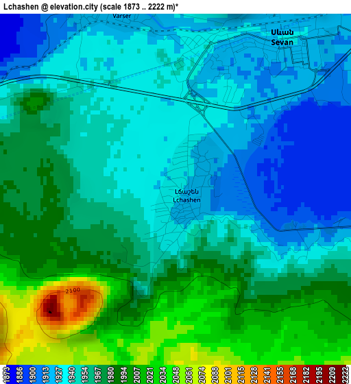
Below is the Elevation map of Lchashen, which displays elevation range with different colors. Scale of the first map is from 1873 to 2222 m (6145 to 7290 ft) with average elevation of 1961.6 meters (=6436 ft) [note 1]
These maps also provides idea of topography and contour of this city, they are displayed at different zoom levels. More info about maps, scale and edge coordinates you can find below images.
| \ | Map #1 | Map #2 | Topo.Map |
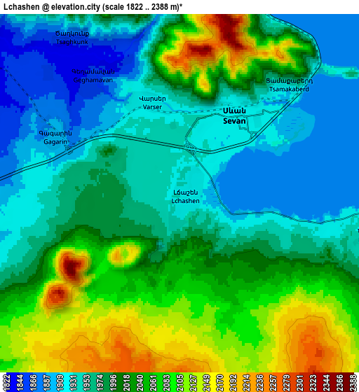
| Scale [m] | 1873..2222 m | 1822..2388 m | × |
| Scale [ft] | 6145..7290 ft | 5978..7835 ft | × |
| Average | 1961.6 m = 6436 ft | 2003.1 m = 6572 ft | × |
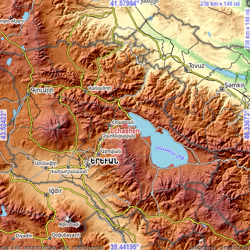
| Width | 7.43 km = 4.6 mi | 14.86 km = 9.2 mi | 237.7 km = 147.7 mi |
| Height | 7.43 km = 4.6 mi | 14.86 km = 9.2 mi | 237.7 km = 147.7 mi |
| ↑Max Latitude | 40.552868° | 40.58625° | 41.57994° |
| Latitude at center | 40.51947° | 40.51947° | 40.51947° |
| ↓Min Latitude | 40.486055° | 40.452624° | 39.44195° |
| ← Min Longitude | 44.886535° | 44.842589° | 43.52423° |
| Longitude center | 44.93048° | 44.93048° | 44.93048° |
| →Max Longitude | 44.974425° | 45.018371° | 46.33673° |
Nearby cities:
Cities around Lchashen sort by population:
• Hrazdan elevation 1762 m
14.1 km,  260°
260°
• Sevan 1934 m
3.2 km,  17°
17°
• Tsovagyugh 2016 m
12.9 km,  11°
11°
• Lerrnanist 1922 m
13.1 km,  243°
243°
• Ddmashen 1798 m
10.7 km,  301°
301°
• Tsovazard 1944 m
11.3 km,  116°
116°
• Varser 1917 m
4.4 km,  334°
334°
• Geghamavan 1853 m
5.9 km,  323°
323°
• Zovaber 1765 m
13 km,  293°
293°
• Tsaghkadzor 1861 m
17.8 km,  274°
274°
• Gagarin 1891 m
5.6 km, 294°
• Lchap’ 1931 m
14.1 km, 120°
Multilingual:
 En español:
Lchashen elevación 1929 m.
 En France:
Lchashen élévation 1929 m.
 Auf Deutsch:
Lchashen höhe über dem Meeresspiegel ist 1929 m.

Sources and notes:
- [note 1] Map square and city borders are not equal. Map elevation data is calculated only from area inside that square.
- [src 1] Elevation data from geonames database provided with same terms of usage.
- [src 2] The elevation map of Lchashen is generated using elevation data from NASA's 3 arcsec (90m) resolution SRTM data.
- [src 3] Base (background) map © OpenStreetMap contributors tiles are generated by Geofabrik and OpenTopoMap.
Copyright & License:
This Lchashen Elevation Map is licensed under CC BY-SA. You may reuse any part from this page, if you give a proper credit by linking to this URL:
 More info on terms of use page.