Kukur elevation
Kukur (Elbasan, Rrethi i Gramshit), Albania elevation is 797 meters and Kukur elevation in feet is 2615 ft above sea level [src 1]. Kukur is a seat of a third-order administrative division (feature code) with elevation that is 423 meters (1388 ft) bigger than average city elevation in Albania.
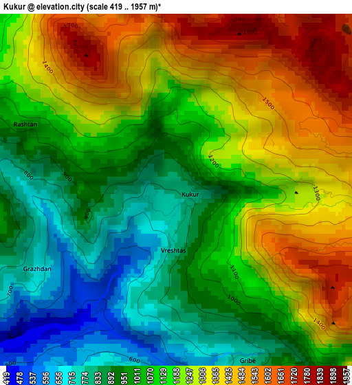
Below is the Elevation map of Kukur, which displays elevation range with different colors. Scale of the first map is from 419 to 1957 m (1375 to 6421 ft) with average elevation of 1134.3 meters (=3721 ft) [note 1]
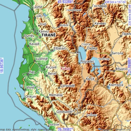
These maps also provides idea of topography and contour of this city, they are displayed at different zoom levels. More info about maps, scale and edge coordinates you can find below images.
| \ | Map #1 | Topo.Map |
| Scale [m] | 419..1957 m | × |
| Scale [ft] | 1375..6421 ft | × |
| Average | 1134.3 m = 3721 ft | × |
| Width | 7.39 km = 4.6 mi | 236.5 km = 147 mi |
| Height | 7.39 km = 4.6 mi | 236.5 km = 147 mi |
| ↑Max Latitude | 40.901004° | 41.92266° |
| Latitude at center | 40.86778° | 40.86778° |
| ↓Min Latitude | 40.834539° | 39.79582° |
| ← Min Longitude | 20.319665° | 18.95736° |
| Longitude center | 20.36361° | 20.36361° |
| →Max Longitude | 20.407555° | 21.76986° |
Nearby cities:
Cities around Kukur sort by population:
• Gramsh elevation 200 m
15.1 km,  270°
270°
• Proptisht 600 m
17.6 km,  41°
41°
• Kushovë 306 m
17.1 km,  239°
239°
• Trebinjë 898 m
16.7 km,  72°
72°
• Stravaj 729 m
16.1 km,  18°
18°
• Pishaj 193 m
15.3 km,  275°
275°
• Skënderbegas 521 m
14.5 km,  225°
225°
• Zavalinë 844 m
14.4 km,  331°
331°
• Velçan 1023 m
12.7 km, 40°
• Kodovjat 276 m
11.7 km, 233°
• Lenias 986 m
11.5 km,  168°
168°
• Poroçan 770 m
9.9 km, 326°
Multilingual:
 En español:
Kukur elevación 797 m.
 En France:
Kukur élévation 797 m.


Sources and notes:
- [note 1] Map square and city borders are not equal. Map elevation data is calculated only from area inside that square.
- [src 1] Elevation data from geonames database provided with same terms of usage.
- [src 2] The elevation map of Kukur is generated using elevation data from NASA's 3 arcsec (90m) resolution SRTM data.
- [src 3] Base (background) map © OpenStreetMap contributors tiles are generated by Geofabrik and OpenTopoMap.
Copyright & License:
This Kukur Elevation Map is licensed under CC BY-SA. You may reuse any part from this page, if you give a proper credit by linking to this URL:
 More info on terms of use page.