Gramsh elevation
Gramsh (Elbasan, Rrethi i Gramshit), Albania elevation is 200 meters and Gramsh elevation in feet is 656 ft above sea level [src 1]. Gramsh is a seat of a second-order administrative division (feature code) with elevation that is 174 meters (571 ft) smaller than average city elevation in Albania.
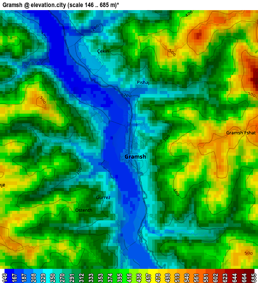
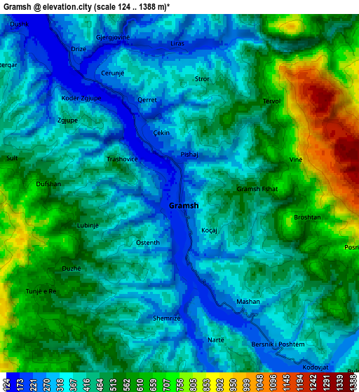
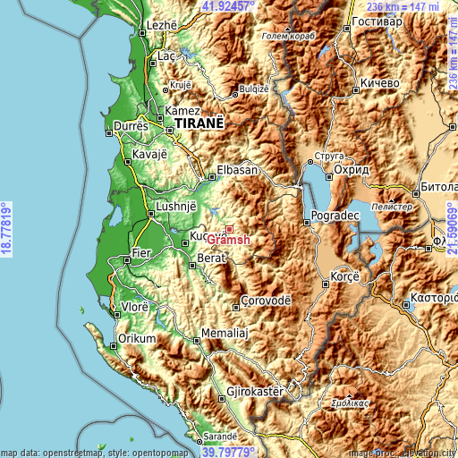
Below is the Elevation map of Gramsh, which displays elevation range with different colors. Scale of the first map is from 146 to 685 m (479 to 2247 ft) with average elevation of 339.1 meters (=1113 ft) [note 1]
These maps also provides idea of topography and contour of this city, they are displayed at different zoom levels. More info about maps, scale and edge coordinates you can find below images.
| \ | Map #1 | Map #2 | Topo.Map |
| Scale [m] | 146..685 m | 124..1388 m | × |
| Scale [ft] | 479..2247 ft | 407..4554 ft | × |
| Average | 339.1 m = 1113 ft | 459.3 m = 1507 ft | × |
| Width | 7.39 km = 4.6 mi | 14.78 km = 9.2 mi | 236.5 km = 147 mi |
| Height | 7.39 km = 4.6 mi | 14.78 km = 9.2 mi | 236.5 km = 147 mi |
| ↑Max Latitude | 40.902943° | 40.936149° | 41.92457° |
| Latitude at center | 40.86972° | 40.86972° | 40.86972° |
| ↓Min Latitude | 40.83648° | 40.803224° | 39.79779° |
| ← Min Longitude | 20.140495° | 20.096549° | 18.77819° |
| Longitude center | 20.18444° | 20.18444° | 20.18444° |
| →Max Longitude | 20.228385° | 20.272331° | 21.59069° |
Nearby cities:
Cities around Gramsh sort by population:
• Klos elevation 109 m
17 km,  300°
300°
• Gjinar 764 m
17 km,  1°
1°
• Mollas 110 m
16.5 km,  292°
292°
• Kukur 797 m
15.1 km,  90°
90°
• Zavalinë 844 m
14.8 km,  33°
33°
• Poroçan 770 m
12.5 km,  50°
50°
• Skënderbegas 521 m
11.4 km,  155°
155°
• Kodovjat 276 m
9.1 km,  141°
141°
• Kushovë 306 m
9 km,  177°
177°
• Sult 439 m
7.3 km,  283°
283°
• Tunjë 597 m
7.3 km,  237°
237°
• Pishaj 193 m
1.3 km,  353°
353°
Multilingual:
 En español:
Gramsh elevación 200 m.
 En France:
Gramsh élévation 200 m.


Sources and notes:
- [note 1] Map square and city borders are not equal. Map elevation data is calculated only from area inside that square.
- [src 1] Elevation data from geonames database provided with same terms of usage.
- [src 2] The elevation map of Gramsh is generated using elevation data from NASA's 3 arcsec (90m) resolution SRTM data.
- [src 3] Base (background) map © OpenStreetMap contributors tiles are generated by Geofabrik and OpenTopoMap.
Copyright & License:
This Gramsh Elevation Map is licensed under CC BY-SA. You may reuse any part from this page, if you give a proper credit by linking to this URL:
 More info on terms of use page.