Zavalinë elevation
Zavalinë (Elbasan, Rrethi i Elbasanit), Albania elevation is 844 meters and Zavalinë elevation in feet is 2769 ft above sea level [src 1]. Zavalinë is a seat of a third-order administrative division (feature code) with elevation that is 470 meters (1542 ft) bigger than average city elevation in Albania.
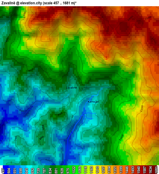
Below is the Elevation map of Zavalinë, which displays elevation range with different colors. Scale of the first map is from 457 to 1681 m (1499 to 5515 ft) with average elevation of 1005.2 meters (=3298 ft) [note 1]
These maps also provides idea of topography and contour of this city, they are displayed at different zoom levels. More info about maps, scale and edge coordinates you can find below images.
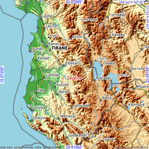
| \ | Map #1 | Topo.Map |
| Scale [m] | 457..1681 m | × |
| Scale [ft] | 1499..5515 ft | × |
| Average | 1005.2 m = 3298 ft | × |
| Width | 7.38 km = 4.6 mi | 236.1 km = 146.7 mi |
| Height | 7.38 km = 4.6 mi | 236.1 km = 146.7 mi |
| ↑Max Latitude | 41.013997° | 42.03389° |
| Latitude at center | 40.98083° | 40.98083° |
| ↓Min Latitude | 40.947646° | 39.91068° |
| ← Min Longitude | 20.236885° | 18.87458° |
| Longitude center | 20.28083° | 20.28083° |
| →Max Longitude | 20.324775° | 21.68708° |
Nearby cities:
Cities around Zavalinë sort by population:
• Gramsh elevation 200 m
14.8 km,  213°
213°
• Proptisht 600 m
18.6 km,  88°
88°
• Tregan 259 m
17.7 km,  286°
286°
• Qukës-Skënderbe 556 m
17.5 km,  49°
49°
• Polis-Gostimë 574 m
17.1 km,  353°
353°
• Shushicë 199 m
17.1 km,  319°
319°
• Velçan 1023 m
15.5 km,  100°
100°
• Kukur 797 m
14.4 km,  151°
151°
• Pishaj 193 m
13.8 km,  216°
216°
• Stravaj 729 m
12.2 km,  77°
77°
• Gjinar 764 m
9 km,  300°
300°
• Poroçan 770 m
4.6 km,  160°
160°
Multilingual:
 En español:
Zavalinë elevación 844 m.
 En France:
Zavalinë élévation 844 m.
 Auf Deutsch:
Zavalinë höhe über dem Meeresspiegel ist 844 m.

Sources and notes:
- [note 1] Map square and city borders are not equal. Map elevation data is calculated only from area inside that square.
- [src 1] Elevation data from geonames database provided with same terms of usage.
- [src 2] The elevation map of Zavalinë is generated using elevation data from NASA's 3 arcsec (90m) resolution SRTM data.
- [src 3] Base (background) map © OpenStreetMap contributors tiles are generated by Geofabrik and OpenTopoMap.
Copyright & License:
This Zavalinë Elevation Map is licensed under CC BY-SA. You may reuse any part from this page, if you give a proper credit by linking to this URL:
 More info on terms of use page.