March elevation
March (Badakhshan, Yāwān), Afghanistan elevation is 1607 meters and March elevation in feet is 5272 ft above sea level [src 1]. March is a seat of a second-order administrative division (feature code) with elevation that is 188 meters (617 ft) bigger than average city elevation in Afghanistan.
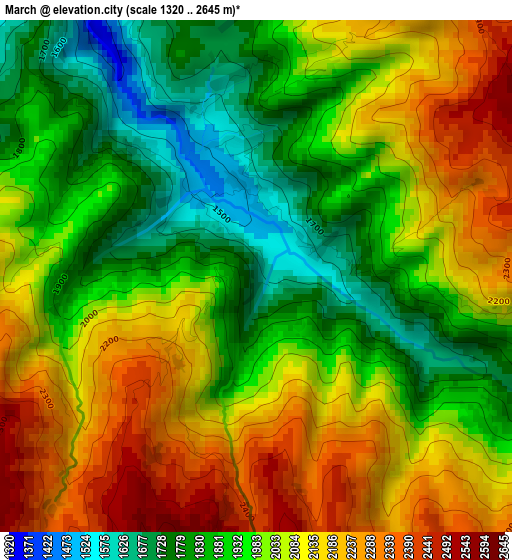
Below is the Elevation map of March, which displays elevation range with different colors. Scale of the first map is from 1320 to 2645 m (4331 to 8678 ft) with average elevation of 2013.7 meters (=6607 ft) [note 1]
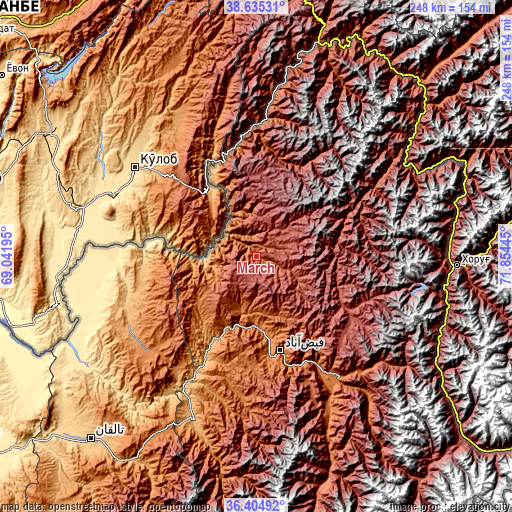
These maps also provides idea of topography and contour of this city, they are displayed at different zoom levels. More info about maps, scale and edge coordinates you can find below images.
| \ | Map #1 | Topo.Map |
| Scale [m] | 1320..2645 m | × |
| Scale [ft] | 4331..8678 ft | × |
| Average | 2013.7 m = 6607 ft | × |
| Width | 7.75 km = 4.8 mi | 248 km = 154.1 mi |
| Height | 7.75 km = 4.8 mi | 248 km = 154.1 mi |
| ↑Max Latitude | 37.563293° | 38.63531° |
| Latitude at center | 37.52845° | 37.52845° |
| ↓Min Latitude | 37.493591° | 36.40492° |
| ← Min Longitude | 70.404255° | 69.04195° |
| Longitude center | 70.4482° | 70.4482° |
| →Max Longitude | 70.492145° | 71.85445° |
Nearby cities:
Cities around March sort by population:
• Fayzabad elevation 1210 m
47.2 km,  165°
165°
• Rustāq 1314 m
70.6 km,  230°
230°
• Darāyim 1693 m
73.8 km,  184°
184°
• Bāzār-e Tashkān 1285 m
73.5 km,  191°
191°
• Bahārak 1552 m
71.2 km,  145°
145°
• Shahrān 2093 m
66.2 km,  157°
157°
• Chāh Āb 1034 m
57.8 km,  255°
255°
• Qal‘ah-ye Kūf 1383 m
57.1 km,  2°
2°
• Ḩāfiz̧ Moghul 1700 m
52.7 km, 184°
• Deh Khwāhān 1047 m
44.9 km,  333°
333°
• Pas Pul 2143 m
16 km,  112°
112°
• Zīrakī 2475 m
12 km,  53°
53°
Multilingual:
 En español:
March elevación 1607 m.
 En France:
March élévation 1607 m.


Sources and notes:
- [note 1] Map square and city borders are not equal. Map elevation data is calculated only from area inside that square.
- [src 1] Elevation data from geonames database provided with same terms of usage.
- [src 2] The elevation map of March is generated using elevation data from NASA's 3 arcsec (90m) resolution SRTM data.
- [src 3] Base (background) map © OpenStreetMap contributors tiles are generated by Geofabrik and OpenTopoMap.
Copyright & License:
This March Elevation Map is licensed under CC BY-SA. You may reuse any part from this page, if you give a proper credit by linking to this URL:
 More info on terms of use page.