Rustāq elevation
Rustāq (Takhar), Afghanistan elevation is 1314 meters and Rustāq elevation in feet is 4311 ft above sea level [src 1]. Rustāq is a seat of a second-order administrative division (feature code) with elevation that is 105 meters (344 ft) smaller than average city elevation in Afghanistan.
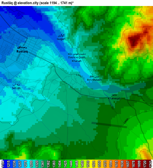
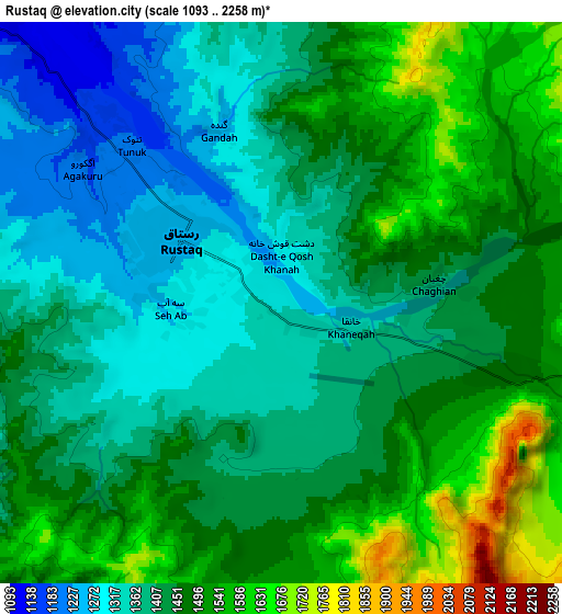
Below is the Elevation map of Rustāq, which displays elevation range with different colors. Scale of the first map is from 1194 to 1741 m (3917 to 5712 ft) with average elevation of 1354.2 meters (=4443 ft) [note 1]
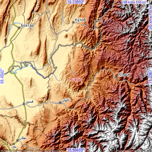
These maps also provides idea of topography and contour of this city, they are displayed at different zoom levels. More info about maps, scale and edge coordinates you can find below images.
| \ | Map #1 | Map #2 | Topo.Map |
| Scale [m] | 1194..1741 m | 1093..2258 m | × |
| Scale [ft] | 3917..5712 ft | 3586..7408 ft | × |
| Average | 1354.2 m = 4443 ft | 1438.3 m = 4719 ft | × |
| Width | 7.79 km = 4.8 mi | 15.58 km = 9.7 mi | 249.3 km = 154.9 mi |
| Height | 7.79 km = 4.8 mi | 15.58 km = 9.7 mi | 249.3 km = 154.9 mi |
| ↑Max Latitude | 37.16107° | 37.196084° | 38.23892° |
| Latitude at center | 37.12604° | 37.12604° | 37.12604° |
| ↓Min Latitude | 37.090994° | 37.055932° | 35.99655° |
| ← Min Longitude | 69.786505° | 69.742559° | 68.4242° |
| Longitude center | 69.83045° | 69.83045° | 69.83045° |
| →Max Longitude | 69.874395° | 69.918341° | 71.2367° |
Nearby cities:
Cities around Rustāq sort by population:
• Taloqan elevation 801 m
50.7 km,  211°
211°
• Ārt Khwājah 481 m
31.4 km,  261°
261°
• Yangī Qal‘ah 471 m
42.5 km,  332°
332°
• Darāyim 1693 m
56.9 km,  120°
120°
• Ḩāfiz̧ Moghul 1700 m
51.2 km,  98°
98°
• Bāzār-e Tashkān 1285 m
48 km, 124°
• Darqad 435 m
44 km,  310°
310°
• Mashhad 977 m
42 km,  144°
144°
• Kalafgān 1590 m
40.6 km,  165°
165°
• Khwājah Ghār 512 m
36.9 km, 259°
• Dasht-e Qal‘ah 449 m
34.4 km,  275°
275°
• Chāh Āb 1034 m
30.2 km,  357°
357°
Multilingual:
 En español:
Rustāq elevación 1314 m.
 En France:
Rustāq élévation 1314 m.


Sources and notes:
- [note 1] Map square and city borders are not equal. Map elevation data is calculated only from area inside that square.
- [src 1] Elevation data from geonames database provided with same terms of usage.
- [src 2] The elevation map of Rustāq is generated using elevation data from NASA's 3 arcsec (90m) resolution SRTM data.
- [src 3] Base (background) map © OpenStreetMap contributors tiles are generated by Geofabrik and OpenTopoMap.
Copyright & License:
This Rustāq Elevation Map is licensed under CC BY-SA. You may reuse any part from this page, if you give a proper credit by linking to this URL:
 More info on terms of use page.