Taloqan elevation
Taloqan (Takhar, Tāluqān), Afghanistan elevation is 801 meters and Taloqan elevation in feet is 2628 ft above sea level [src 1]. Taloqan is a seat of a first-order administrative division (feature code) with elevation that is 618 meters (2028 ft) smaller than average city elevation in Afghanistan.
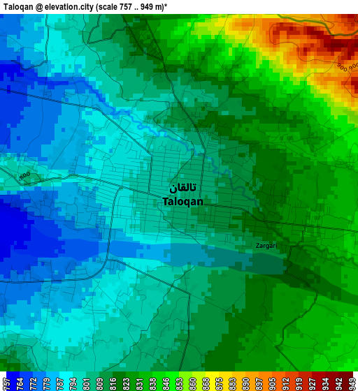
Below is the Elevation map of Taloqan, which displays elevation range with different colors. Scale of the first map is from 757 to 949 m (2484 to 3114 ft) with average elevation of 811.7 meters (=2663 ft) [note 1]
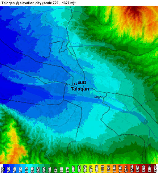
These maps also provides idea of topography and contour of this city, they are displayed at different zoom levels. More info about maps, scale and edge coordinates you can find below images.
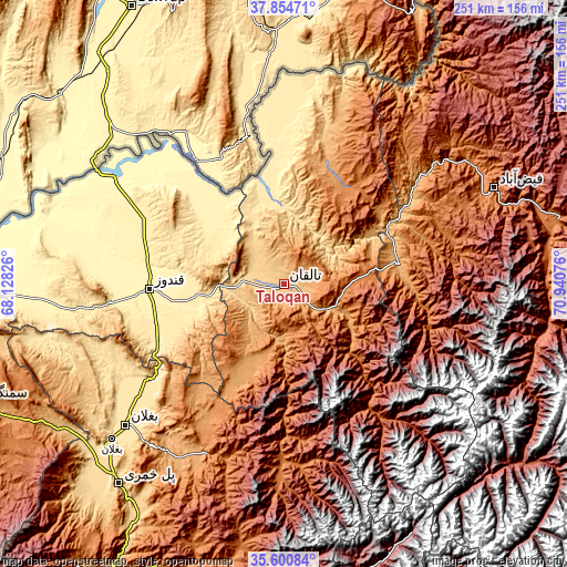
| \ | Map #1 | Map #2 | Topo.Map |
| Scale [m] | 757..949 m | 722..1327 m | × |
| Scale [ft] | 2484..3114 ft | 2369..4354 ft | × |
| Average | 811.7 m = 2663 ft | 870 m = 2854 ft | × |
| Width | 7.83 km = 4.9 mi | 15.66 km = 9.7 mi | 250.6 km = 155.7 mi |
| Height | 7.83 km = 4.9 mi | 15.66 km = 9.7 mi | 250.6 km = 155.7 mi |
| ↑Max Latitude | 36.77126° | 36.806453° | 37.85471° |
| Latitude at center | 36.73605° | 36.73605° | 36.73605° |
| ↓Min Latitude | 36.700824° | 36.665582° | 35.60084° |
| ← Min Longitude | 69.490565° | 69.446619° | 68.12826° |
| Longitude center | 69.53451° | 69.53451° | 69.53451° |
| →Max Longitude | 69.578455° | 69.622401° | 70.94076° |
Nearby cities:
Cities around Taloqan sort by population:
• Khanabad elevation 503 m
37.8 km,  260°
260°
• Rustāq 1314 m
50.7 km,  31°
31°
• Ārt Khwājah 481 m
39.2 km,  352°
352°
• Farkhār 1153 m
34.1 km,  122°
122°
• Dasht-e Archī 379 m
55 km,  323°
323°
• Mashhad 977 m
51.3 km,  79°
79°
• Dasht-e Qal‘ah 449 m
47.2 km, 350°
• Khwājah Ghār 512 m
38 km,  344°
344°
• Kalafgān 1590 m
36.8 km, 83°
• Afaki 711 m
18.3 km,  243°
243°
• Ţāqchah Khānah 1071 m
15.4 km,  147°
147°
• Khānaqāh 1378 m
12.3 km,  178°
178°
Multilingual:
 En español:
Taloqan elevación 801 m.
 En France:
Tâloqân élévation 801 m.


Sources and notes:
- [note 1] Map square and city borders are not equal. Map elevation data is calculated only from area inside that square.
- [src 1] Elevation data from geonames database provided with same terms of usage.
- [src 2] The elevation map of Taloqan is generated using elevation data from NASA's 3 arcsec (90m) resolution SRTM data.
- [src 3] Base (background) map © OpenStreetMap contributors tiles are generated by Geofabrik and OpenTopoMap.
Copyright & License:
This Taloqan Elevation Map is licensed under CC BY-SA. You may reuse any part from this page, if you give a proper credit by linking to this URL:
 More info on terms of use page.