Fayzabad elevation
Fayzabad (Badakhshan, Faīẕābād), Afghanistan elevation is 1210 meters and Fayzabad elevation in feet is 3970 ft above sea level [src 1]. Fayzabad is a seat of a first-order administrative division (feature code) with elevation that is 209 meters (686 ft) smaller than average city elevation in Afghanistan.
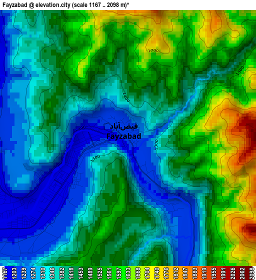
Below is the Elevation map of Fayzabad, which displays elevation range with different colors. Scale of the first map is from 1167 to 2098 m (3829 to 6883 ft) with average elevation of 1437.6 meters (=4717 ft) [note 1]
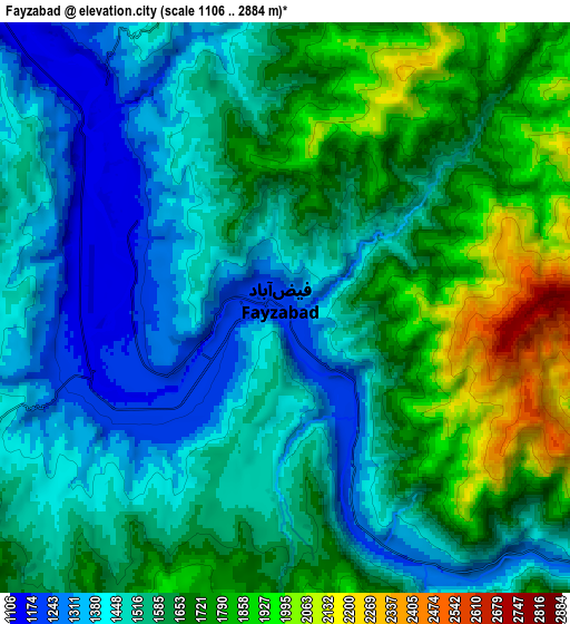
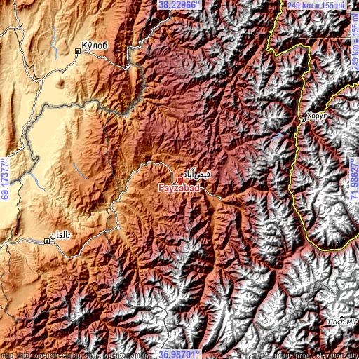
These maps also provides idea of topography and contour of this city, they are displayed at different zoom levels. More info about maps, scale and edge coordinates you can find below images.
| \ | Map #1 | Map #2 | Topo.Map |
| Scale [m] | 1167..2098 m | 1106..2884 m | × |
| Scale [ft] | 3829..6883 ft | 3629..9462 ft | × |
| Average | 1437.6 m = 4717 ft | 1587.6 m = 5209 ft | × |
| Width | 7.79 km = 4.8 mi | 15.59 km = 9.7 mi | 249.4 km = 155 mi |
| Height | 7.79 km = 4.8 mi | 15.59 km = 9.7 mi | 249.4 km = 155 mi |
| ↑Max Latitude | 37.151674° | 37.186692° | 38.22966° |
| Latitude at center | 37.11664° | 37.11664° | 37.11664° |
| ↓Min Latitude | 37.08159° | 37.046523° | 35.98701° |
| ← Min Longitude | 70.536075° | 70.492129° | 69.17377° |
| Longitude center | 70.58002° | 70.58002° | 70.58002° |
| →Max Longitude | 70.623965° | 70.667911° | 71.98627° |
Nearby cities:
Cities around Fayzabad sort by population:
• Rustāq elevation 1314 m
66.5 km,  270°
270°
• Jurm 1564 m
36 km,  141°
141°
• Mashhad 977 m
54 km,  231°
231°
• Zīrakī 2475 m
52.9 km,  357°
357°
• Chākarān 1759 m
49 km,  117°
117°
• March 1607 m
47.2 km,  345°
345°
• Pas Pul 2143 m
39.8 km,  4°
4°
• Bāzār-e Tashkān 1285 m
37.5 km, 225°
• Darāyim 1693 m
32.8 km,  212°
212°
• Bahārak 1552 m
31.6 km,  113°
113°
• Shahrān 2093 m
20.8 km, 137°
• Ḩāfiz̧ Moghul 1700 m
17.3 km,  247°
247°
Multilingual:
 En español:
Fayzabad elevación 1210 m.
 En France:
Fayzabad élévation 1210 m.
 Auf Deutsch:
Fayzabad höhe über dem Meeresspiegel ist 1210 m.

Sources and notes:
- [note 1] Map square and city borders are not equal. Map elevation data is calculated only from area inside that square.
- [src 1] Elevation data from geonames database provided with same terms of usage.
- [src 2] The elevation map of Fayzabad is generated using elevation data from NASA's 3 arcsec (90m) resolution SRTM data.
- [src 3] Base (background) map © OpenStreetMap contributors tiles are generated by Geofabrik and OpenTopoMap.
Copyright & License:
This Fayzabad Elevation Map is licensed under CC BY-SA. You may reuse any part from this page, if you give a proper credit by linking to this URL:
 More info on terms of use page.