Khandūd elevation
Khandūd (Badakhshan, Wākhān), Afghanistan elevation is 2807 meters and Khandūd elevation in feet is 9209 ft above sea level [src 1]. Khandūd is a seat of a second-order administrative division (feature code) with elevation that is 1388 meters (4554 ft) bigger than average city elevation in Afghanistan.
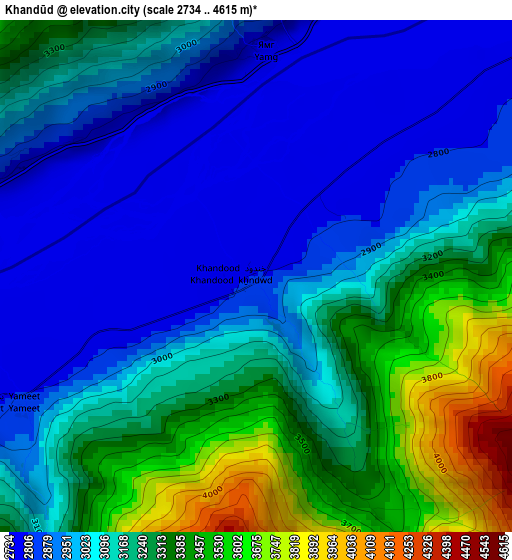
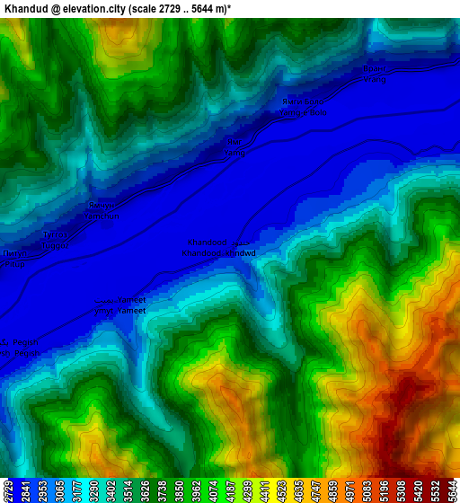
Below is the Elevation map of Khandūd, which displays elevation range with different colors. Scale of the first map is from 2734 to 4615 m (8970 to 15141 ft) with average elevation of 3120 meters (=10236 ft) [note 1]
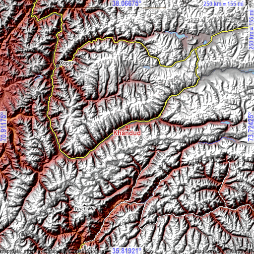
These maps also provides idea of topography and contour of this city, they are displayed at different zoom levels. More info about maps, scale and edge coordinates you can find below images.
| \ | Map #1 | Map #2 | Topo.Map |
| Scale [m] | 2734..4615 m | 2729..5644 m | × |
| Scale [ft] | 8970..15141 ft | 8953..18517 ft | × |
| Average | 3120 m = 10236 ft | 3561.2 m = 11684 ft | × |
| Width | 7.81 km = 4.9 mi | 15.62 km = 9.7 mi | 249.9 km = 155.3 mi |
| Height | 7.81 km = 4.9 mi | 15.62 km = 9.7 mi | 249.9 km = 155.3 mi |
| ↑Max Latitude | 36.986381° | 37.021475° | 38.06675° |
| Latitude at center | 36.95127° | 36.95127° | 36.95127° |
| ↓Min Latitude | 36.916143° | 36.881° | 35.81921° |
| ← Min Longitude | 72.274055° | 72.230109° | 70.91175° |
| Longitude center | 72.318° | 72.318° | 72.318° |
| →Max Longitude | 72.361945° | 72.405891° | 73.72425° |
Nearby cities:
Cities around Khandūd sort by population:
• Fayzabad elevation 1210 m
155.4 km,  276°
276°
• Ashkāsham 3057 m
75.9 km,  246°
246°
• Jurm 1564 m
132.3 km,  265°
265°
• Zīrakī 2475 m
171.2 km,  294°
294°
• Ḩāfiz̧ Moghul 1700 m
170.7 km, 273°
• Barg-e Matāl 2077 m
166.8 km,  211°
211°
• Pas Pul 2143 m
161.5 km, 291°
• Ghurayd Gharamē 1884 m
144.2 km, 250°
• Shahrān 2093 m
140.3 km, 271°
• Bahārak 1552 m
125.5 km, 272°
• Chākarān 1759 m
111.1 km, 267°
• Zaybāk 2616 m
98.6 km,  241°
241°
Multilingual:
 En español:
Khandūd elevación 2807 m.
 En France:
Khandūd élévation 2807 m.
 Auf Deutsch:
Khandūd höhe über dem Meeresspiegel ist 2807 m.

Sources and notes:
- [note 1] Map square and city borders are not equal. Map elevation data is calculated only from area inside that square.
- [src 1] Elevation data from geonames database provided with same terms of usage.
- [src 2] The elevation map of Khandūd is generated using elevation data from NASA's 3 arcsec (90m) resolution SRTM data.
- [src 3] Base (background) map © OpenStreetMap contributors tiles are generated by Geofabrik and OpenTopoMap.
Copyright & License:
This Khandūd Elevation Map is licensed under CC BY-SA. You may reuse any part from this page, if you give a proper credit by linking to this URL:
 More info on terms of use page.