Zaybāk elevation
Zaybāk (Badakhshan), Afghanistan elevation is 2616 meters and Zaybāk elevation in feet is 8583 ft above sea level [src 1]. Zaybāk is a seat of a second-order administrative division (feature code) with elevation that is 1197 meters (3927 ft) bigger than average city elevation in Afghanistan.
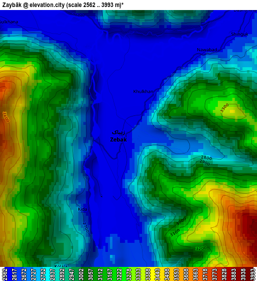
Below is the Elevation map of Zaybāk, which displays elevation range with different colors. Scale of the first map is from 2562 to 3993 m (8406 to 13100 ft) with average elevation of 2919.4 meters (=9578 ft) [note 1]
These maps also provides idea of topography and contour of this city, they are displayed at different zoom levels. More info about maps, scale and edge coordinates you can find below images.
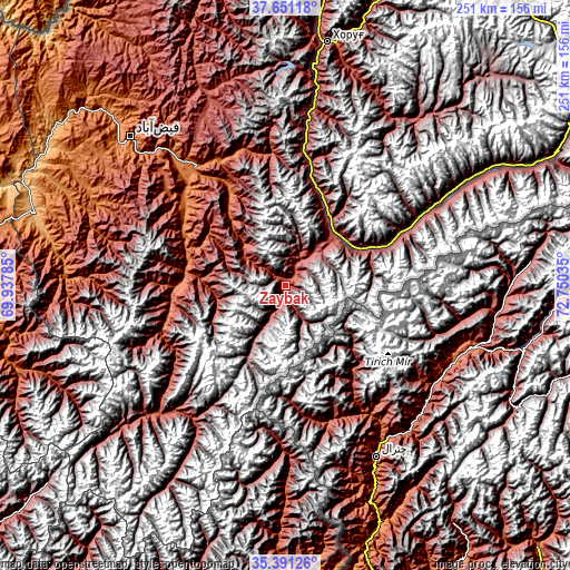
| \ | Map #1 | Topo.Map |
| Scale [m] | 2562..3993 m | × |
| Scale [ft] | 8406..13100 ft | × |
| Average | 2919.4 m = 9578 ft | × |
| Width | 7.85 km = 4.9 mi | 251.3 km = 156.2 mi |
| Height | 7.85 km = 4.9 mi | 251.3 km = 156.2 mi |
| ↑Max Latitude | 36.564774° | 37.65118° |
| Latitude at center | 36.52947° | 36.52947° |
| ↓Min Latitude | 36.49415° | 35.39126° |
| ← Min Longitude | 71.300155° | 69.93785° |
| Longitude center | 71.3441° | 71.3441° |
| →Max Longitude | 71.388045° | 72.75035° |
Nearby cities:
Cities around Zaybāk sort by population:
• Fayzabad elevation 1210 m
94.3 km,  313°
313°
• Ashkāsham 3057 m
24 km,  44°
44°
• Jurm 1564 m
58.8 km, 309°
• Khandūd 2807 m
98.6 km,  61°
61°
• Ḩāfiz̧ Moghul 1700 m
102.4 km,  304°
304°
• Barg-e Matāl 2077 m
95.2 km,  180°
180°
• Darāyim 1693 m
93.5 km,  293°
293°
• Kuran wa Munjan 2550 m
75.7 km,  222°
222°
• Shahrān 2093 m
73.6 km, 312°
• Bahārak 1552 m
65.5 km,  323°
323°
• Ghurayd Gharamē 1884 m
49.5 km,  269°
269°
• Chākarān 1759 m
49 km,  329°
329°
Multilingual:
 En español:
Zaybāk elevación 2616 m.
 En France:
Zaybāk élévation 2616 m.


Sources and notes:
- [note 1] Map square and city borders are not equal. Map elevation data is calculated only from area inside that square.
- [src 1] Elevation data from geonames database provided with same terms of usage.
- [src 2] The elevation map of Zaybāk is generated using elevation data from NASA's 3 arcsec (90m) resolution SRTM data.
- [src 3] Base (background) map © OpenStreetMap contributors tiles are generated by Geofabrik and OpenTopoMap.
Copyright & License:
This Zaybāk Elevation Map is licensed under CC BY-SA. You may reuse any part from this page, if you give a proper credit by linking to this URL:
 More info on terms of use page.