Chahār Bāgh elevation
Chahār Bāgh (Faryab, Khān-e Chahār Bāgh), Afghanistan elevation is 284 meters and Chahār Bāgh elevation in feet is 932 ft above sea level [src 1]. Chahār Bāgh is a seat of a second-order administrative division (feature code) with elevation that is 1135 meters (3724 ft) smaller than average city elevation in Afghanistan.
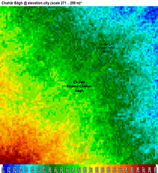
Below is the Elevation map of Chahār Bāgh, which displays elevation range with different colors. Scale of the first map is from 271 to 299 m (889 to 981 ft) with average elevation of 282.5 meters (=927 ft) [note 1]
These maps also provides idea of topography and contour of this city, they are displayed at different zoom levels. More info about maps, scale and edge coordinates you can find below images.
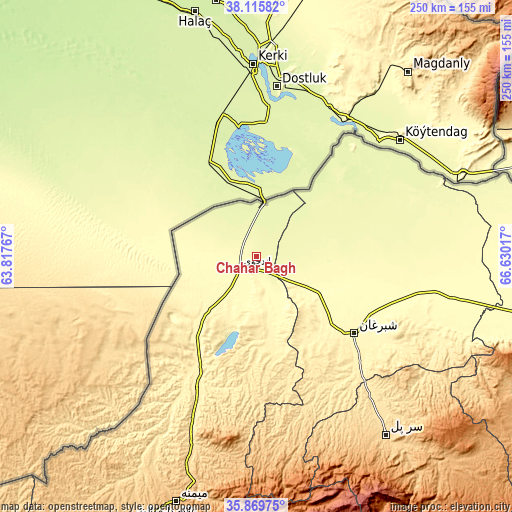
| \ | Map #1 | Topo.Map |
| Scale [m] | 271..299 m | × |
| Scale [ft] | 889..981 ft | × |
| Average | 282.5 m = 927 ft | × |
| Width | 7.8 km = 4.8 mi | 249.7 km = 155.2 mi |
| Height | 7.8 km = 4.8 mi | 249.7 km = 155.2 mi |
| ↑Max Latitude | 37.036168° | 38.11582° |
| Latitude at center | 37.00108° | 37.00108° |
| ↓Min Latitude | 36.965976° | 35.86975° |
| ← Min Longitude | 65.179975° | 63.81767° |
| Longitude center | 65.22392° | 65.22392° |
| →Max Longitude | 65.267865° | 66.63017° |
Nearby cities:
Cities around Chahār Bāgh sort by population:
• Shibirghān elevation 360 m
59.9 km,  128°
128°
• Andkhōy 306 m
10.4 km,  238°
238°
• Qarqīn 263 m
86.2 km,  57°
57°
• Āqchah 293 m
85.9 km,  97°
97°
• Fayẕābād 495 m
85.3 km,  202°
202°
• Khānaqāh 299 m
85.2 km, 100°
• Mingajik 280 m
80.3 km,  87°
87°
• Khamyāb 254 m
75.2 km,  38°
38°
• Dowlatābād 413 m
68.7 km, 203°
• Khwājah Dū Kōh 307 m
40.4 km,  118°
118°
• Qaram Qōl 334 m
24.9 km,  220°
220°
• Qurghān 312 m
16.8 km, 237°
Multilingual:
 En español:
Chahār Bāgh elevación 284 m.
 En France:
Chahār Bāgh élévation 284 m.
 Auf Deutsch:
Chahār Bāgh höhe über dem Meeresspiegel ist 284 m.

Sources and notes:
- [note 1] Map square and city borders are not equal. Map elevation data is calculated only from area inside that square.
- [src 1] Elevation data from geonames database provided with same terms of usage.
- [src 2] The elevation map of Chahār Bāgh is generated using elevation data from NASA's 3 arcsec (90m) resolution SRTM data.
- [src 3] Base (background) map © OpenStreetMap contributors tiles are generated by Geofabrik and OpenTopoMap.
Copyright & License:
This Chahār Bāgh Elevation Map is licensed under CC BY-SA. You may reuse any part from this page, if you give a proper credit by linking to this URL:
 More info on terms of use page.