Qarqīn elevation
Qarqīn (Jowzjan), Afghanistan elevation is 263 meters and Qarqīn elevation in feet is 863 ft above sea level [src 1]. Qarqīn is a seat of a second-order administrative division (feature code) with elevation that is 1156 meters (3793 ft) smaller than average city elevation in Afghanistan.
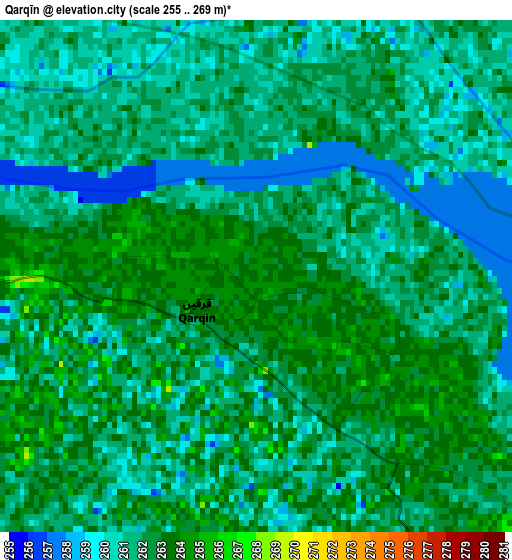
Below is the Elevation map of Qarqīn, which displays elevation range with different colors. Scale of the first map is from 255 to 269 m (837 to 883 ft) with average elevation of 261.5 meters (=858 ft) [note 1]
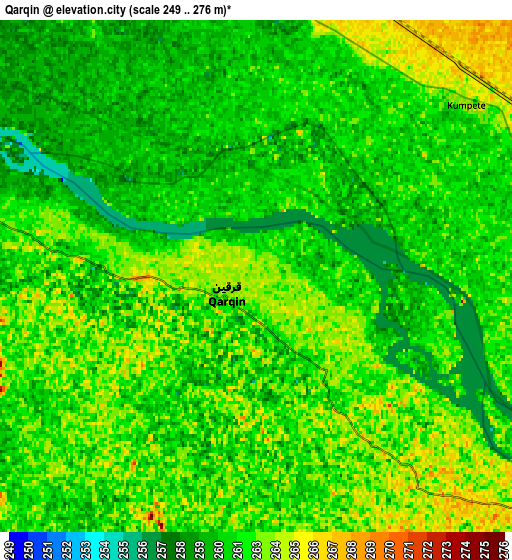
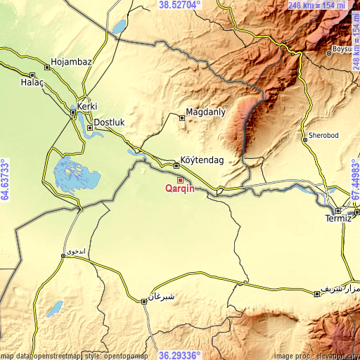
These maps also provides idea of topography and contour of this city, they are displayed at different zoom levels. More info about maps, scale and edge coordinates you can find below images.
| \ | Map #1 | Map #2 | Topo.Map |
| Scale [m] | 255..269 m | 249..276 m | × |
| Scale [ft] | 837..883 ft | 817..906 ft | × |
| Average | 261.5 m = 858 ft | 261.6 m = 858 ft | × |
| Width | 7.76 km = 4.8 mi | 15.52 km = 9.6 mi | 248.4 km = 154.3 mi |
| Height | 7.76 km = 4.8 mi | 15.52 km = 9.6 mi | 248.4 km = 154.3 mi |
| ↑Max Latitude | 37.453424° | 37.488302° | 38.52704° |
| Latitude at center | 37.41853° | 37.41853° | 37.41853° |
| ↓Min Latitude | 37.38362° | 37.348693° | 36.29336° |
| ← Min Longitude | 65.999635° | 65.955689° | 64.63733° |
| Longitude center | 66.04358° | 66.04358° | 66.04358° |
| →Max Longitude | 66.087525° | 66.131471° | 67.44983° |
Nearby cities:
Cities around Qarqīn sort by population:
• Shibirghān elevation 360 m
87.4 km,  197°
197°
• Andkhōy 306 m
96.5 km,  237°
237°
• Qarchī Gak 306 m
78.3 km,  122°
122°
• Chahār Bāgh 284 m
86.2 km, 237°
• Dowlatābād 312 m
83.8 km, 124°
• Faīẕābād 312 m
76 km,  150°
150°
• Khwājah Dū Kōh 307 m
75.4 km,  209°
209°
• Khānaqāh 299 m
62.7 km,  169°
169°
• Āqchah 293 m
58.4 km, 167°
• Mardīān 287 m
52.4 km, 154°
• Mingajik 280 m
44.1 km, 170°
• Khamyāb 254 m
27.9 km,  295°
295°
Multilingual:
 En español:
Qarqīn elevación 263 m.
 En France:
Qarqīn élévation 263 m.


Sources and notes:
- [note 1] Map square and city borders are not equal. Map elevation data is calculated only from area inside that square.
- [src 1] Elevation data from geonames database provided with same terms of usage.
- [src 2] The elevation map of Qarqīn is generated using elevation data from NASA's 3 arcsec (90m) resolution SRTM data.
- [src 3] Base (background) map © OpenStreetMap contributors tiles are generated by Geofabrik and OpenTopoMap.
Copyright & License:
This Qarqīn Elevation Map is licensed under CC BY-SA. You may reuse any part from this page, if you give a proper credit by linking to this URL:
 More info on terms of use page.