Fayẕābād elevation
Fayẕābād (Faryab, Shīrīn Tagāb), Afghanistan elevation is 495 meters and Fayẕābād elevation in feet is 1624 ft above sea level [src 1]. Fayẕābād is a seat of a second-order administrative division (feature code) with elevation that is 924 meters (3031 ft) smaller than average city elevation in Afghanistan.
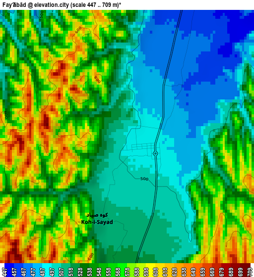
Below is the Elevation map of Fayẕābād, which displays elevation range with different colors. Scale of the first map is from 447 to 709 m (1467 to 2326 ft) with average elevation of 539.6 meters (=1770 ft) [note 1]
These maps also provides idea of topography and contour of this city, they are displayed at different zoom levels. More info about maps, scale and edge coordinates you can find below images.
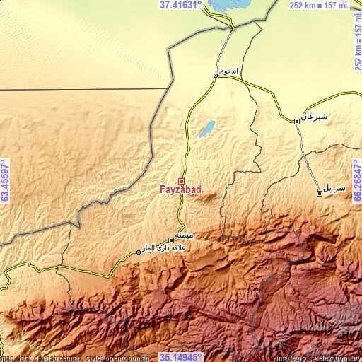
| \ | Map #1 | Topo.Map |
| Scale [m] | 447..709 m | × |
| Scale [ft] | 1467..2326 ft | × |
| Average | 539.6 m = 1770 ft | × |
| Width | 7.88 km = 4.9 mi | 252.1 km = 156.6 mi |
| Height | 7.88 km = 4.9 mi | 252.1 km = 156.6 mi |
| ↑Max Latitude | 36.326523° | 37.41631° |
| Latitude at center | 36.29111° | 36.29111° |
| ↓Min Latitude | 36.255681° | 35.14945° |
| ← Min Longitude | 64.818275° | 63.45597° |
| Longitude center | 64.86222° | 64.86222° |
| →Max Longitude | 64.906165° | 66.26847° |
Nearby cities:
Cities around Fayẕābād sort by population:
• Maymana elevation 864 m
41.7 km,  189°
189°
• Andkhōy 306 m
77.2 km,  17°
17°
• Darzāb 1179 m
58 km,  126°
126°
• Şayād 946 m
88.5 km,  101°
101°
• Chahār Bāgh 284 m
85.3 km, 22°
• Sangalak-i-Kaisar 1258 m
84.4 km,  217°
217°
• Sar Chakān 1348 m
73.4 km,  153°
153°
• Qurghān 312 m
72.2 km,  14°
14°
• Qaram Qōl 334 m
62.1 km, 15°
• Bal Chirāgh 1163 m
60.1 km, 146°
• ‘Alāqahdārī-ye Almār 840 m
57.8 km,  211°
211°
• Dowlatābād 413 m
16.6 km, 18°
Multilingual:
 En español:
Fayẕābād elevación 495 m.
 En France:
Fayẕābād élévation 495 m.
 Auf Deutsch:
Fayẕābād höhe über dem Meeresspiegel ist 495 m.

Sources and notes:
- [note 1] Map square and city borders are not equal. Map elevation data is calculated only from area inside that square.
- [src 1] Elevation data from geonames database provided with same terms of usage.
- [src 2] The elevation map of Fayẕābād is generated using elevation data from NASA's 3 arcsec (90m) resolution SRTM data.
- [src 3] Base (background) map © OpenStreetMap contributors tiles are generated by Geofabrik and OpenTopoMap.
Copyright & License:
This Fayẕābād Elevation Map is licensed under CC BY-SA. You may reuse any part from this page, if you give a proper credit by linking to this URL:
 More info on terms of use page.