Chipinge elevation
Chipinge (Manicaland), Zimbabwe elevation is 1109 meters and Chipinge elevation in feet is 3638 ft above sea level [src 1]. Chipinge is a populated place (feature code) with elevation that is 91 meters (299 ft) smaller than average city elevation in Zimbabwe.
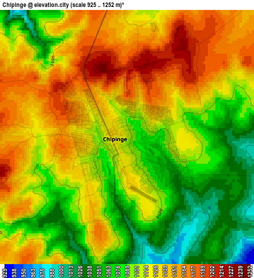
Below is the Elevation map of Chipinge, which displays elevation range with different colors. Scale of the first map is from 925 to 1252 m (3035 to 4108 ft) with average elevation of 1111.3 meters (=3646 ft) [note 1]
These maps also provides idea of topography and contour of this city, they are displayed at different zoom levels. More info about maps, scale and edge coordinates you can find below images.
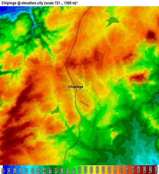
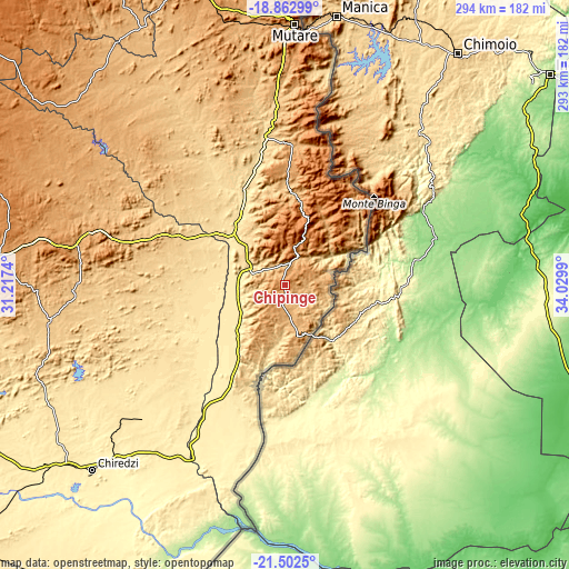
| \ | Map #1 | Map #2 | Topo.Map |
| Scale [m] | 925..1252 m | 721..1305 m | × |
| Scale [ft] | 3035..4108 ft | 2365..4281 ft | × |
| Average | 1111.3 m = 3646 ft | 1068.8 m = 3507 ft | × |
| Width | 9.17 km = 5.7 mi | 18.34 km = 11.4 mi | 293.5 km = 182.4 mi |
| Height | 9.17 km = 5.7 mi | 18.34 km = 11.4 mi | 293.5 km = 182.4 mi |
| ↑Max Latitude | -20.147079° | -20.105817° | -18.86299° |
| Latitude at center | -20.18833° | -20.18833° | -20.18833° |
| ↓Min Latitude | -20.22957° | -20.270799° | -21.5025° |
| ← Min Longitude | 32.579705° | 32.535759° | 31.2174° |
| Longitude center | 32.62365° | 32.62365° | 32.62365° |
| →Max Longitude | 32.667595° | 32.711541° | 34.0299° |
Nearby cities:
Cities around Chipinge sort by population:
• Mutare elevation 1116 m
135.5 km,  2°
2°
• Masvingo 1091 m
188 km,  274°
274°
• Rusape 1415 m
191.8 km,  344°
344°
• Chiredzi 436 m
138.2 km,  226°
226°
• Chivhu 1450 m
223 km,  305°
305°
• Penhalonga 1364 m
144.4 km, 3°
• Nyanga 1706 m
219.6 km, 3°
• Odzi 1005 m
138.3 km,  350°
350°
• Chimanimani 1565 m
50.1 km,  30°
30°
• Nyazura 1243 m
171.6 km, 343°
• Headlands 1563 m
220.8 km, 344°
• Dorowa Mining Lease 916 m
154.7 km,  323°
323°
Multilingual:
 En español:
Chipinge elevación 1109 m.
 En France:
Chipinge élévation 1109 m.
 Auf Deutsch:
Chipinge höhe über dem Meeresspiegel ist 1109 m.

Sources and notes:
- [note 1] Map square and city borders are not equal. Map elevation data is calculated only from area inside that square.
- [src 1] Elevation data from geonames database provided with same terms of usage.
- [src 2] The elevation map of Chipinge is generated using elevation data from NASA's 3 arcsec (90m) resolution SRTM data.
- [src 3] Base (background) map © OpenStreetMap contributors tiles are generated by Geofabrik and OpenTopoMap.
Copyright & License:
This Chipinge Elevation Map is licensed under CC BY-SA. You may reuse any part from this page, if you give a proper credit by linking to this URL:
 More info on terms of use page.