Penhalonga elevation
Penhalonga (Manicaland), Zimbabwe elevation is 1364 meters and Penhalonga elevation in feet is 4475 ft above sea level [src 1]. Penhalonga is a populated place (feature code) with elevation that is 164 meters (538 ft) bigger than average city elevation in Zimbabwe.
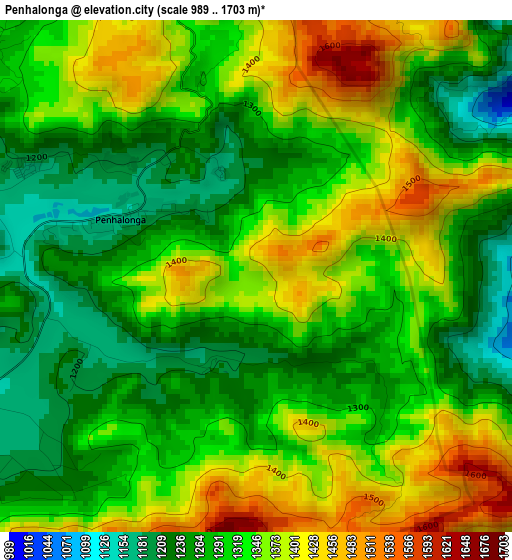
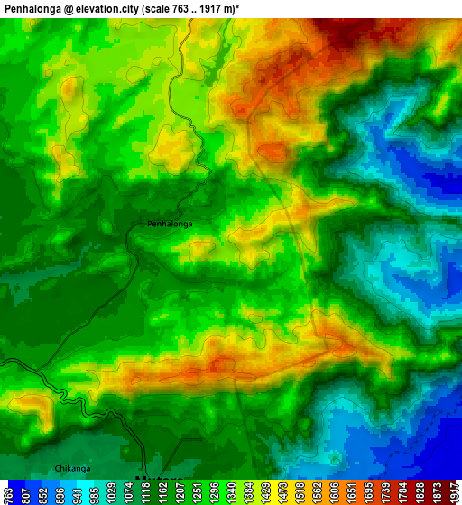
Below is the Elevation map of Penhalonga, which displays elevation range with different colors. Scale of the first map is from 989 to 1703 m (3245 to 5587 ft) with average elevation of 1322 meters (=4337 ft) [note 1]
These maps also provides idea of topography and contour of this city, they are displayed at different zoom levels. More info about maps, scale and edge coordinates you can find below images.
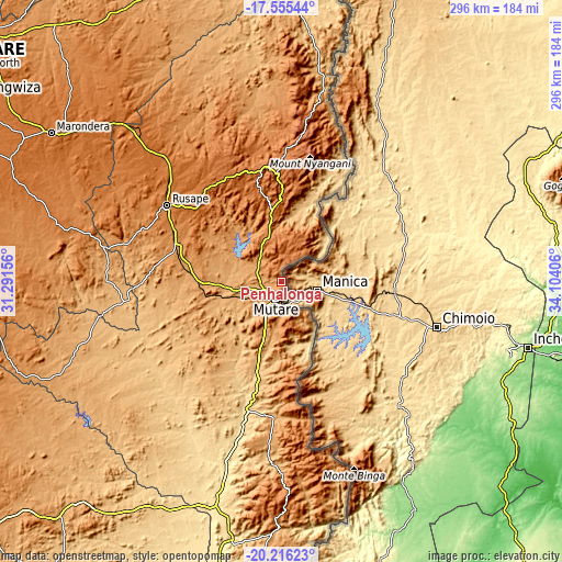
| \ | Map #1 | Map #2 | Topo.Map |
| Scale [m] | 989..1703 m | 763..1917 m | × |
| Scale [ft] | 3245..5587 ft | 2503..6289 ft | × |
| Average | 1322 m = 4337 ft | 1248.1 m = 4095 ft | × |
| Width | 9.25 km = 5.7 mi | 18.49 km = 11.5 mi | 295.9 km = 183.9 mi |
| Height | 9.25 km = 5.7 mi | 18.49 km = 11.5 mi | 295.9 km = 183.9 mi |
| ↑Max Latitude | -18.849537° | -18.807943° | -17.55544° |
| Latitude at center | -18.89112° | -18.89112° | -18.89112° |
| ↓Min Latitude | -18.932693° | -18.974256° | -20.21623° |
| ← Min Longitude | 32.653865° | 32.609919° | 31.29156° |
| Longitude center | 32.69781° | 32.69781° | 32.69781° |
| →Max Longitude | 32.741755° | 32.785701° | 34.10406° |
Nearby cities:
Cities around Penhalonga sort by population:
• Mutare elevation 1116 m
9.3 km,  197°
197°
• Marondera 1668 m
144.1 km,  303°
303°
• Rusape 1415 m
72.3 km, 303°
• Chipinge 1109 m
144.4 km,  183°
183°
• Murehwa 1365 m
169 km,  325°
325°
• Nyanga 1706 m
75.2 km,  4°
4°
• Macheke 1527 m
122.5 km,  313°
313°
• Odzi 1005 m
31.7 km,  255°
255°
• Chimanimani 1565 m
102.6 km,  170°
170°
• Nyazura 1243 m
59.5 km,  290°
290°
• Headlands 1563 m
96.4 km,  315°
315°
• Dorowa Mining Lease 916 m
101.6 km, 258°
Multilingual:
 En español:
Penhalonga elevación 1364 m.
 En France:
Penhalonga élévation 1364 m.
 Auf Deutsch:
Penhalonga höhe über dem Meeresspiegel ist 1364 m.

Sources and notes:
- [note 1] Map square and city borders are not equal. Map elevation data is calculated only from area inside that square.
- [src 1] Elevation data from geonames database provided with same terms of usage.
- [src 2] The elevation map of Penhalonga is generated using elevation data from NASA's 3 arcsec (90m) resolution SRTM data.
- [src 3] Base (background) map © OpenStreetMap contributors tiles are generated by Geofabrik and OpenTopoMap.
Copyright & License:
This Penhalonga Elevation Map is licensed under CC BY-SA. You may reuse any part from this page, if you give a proper credit by linking to this URL:
 More info on terms of use page.