Macheke elevation
Macheke (Mashonaland East), Zimbabwe elevation is 1527 meters and Macheke elevation in feet is 5010 ft above sea level [src 1]. Macheke is a populated place (feature code) with elevation that is 327 meters (1073 ft) bigger than average city elevation in Zimbabwe.
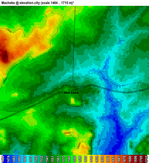
Below is the Elevation map of Macheke, which displays elevation range with different colors. Scale of the first map is from 1464 to 1715 m (4803 to 5627 ft) with average elevation of 1550.6 meters (=5087 ft) [note 1]
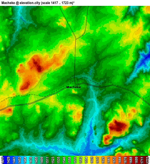
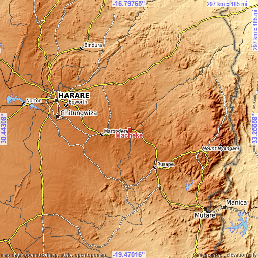
These maps also provides idea of topography and contour of this city, they are displayed at different zoom levels. More info about maps, scale and edge coordinates you can find below images.
| \ | Map #1 | Map #2 | Topo.Map |
| Scale [m] | 1464..1715 m | 1417..1723 m | × |
| Scale [ft] | 4803..5627 ft | 4649..5653 ft | × |
| Average | 1550.6 m = 5087 ft | 1544.3 m = 5067 ft | × |
| Width | 9.29 km = 5.8 mi | 18.57 km = 11.5 mi | 297.2 km = 184.7 mi |
| Height | 9.29 km = 5.8 mi | 18.57 km = 11.5 mi | 297.2 km = 184.7 mi |
| ↑Max Latitude | -18.097244° | -18.055467° | -16.79765° |
| Latitude at center | -18.13901° | -18.13901° | -18.13901° |
| ↓Min Latitude | -18.180766° | -18.222513° | -19.47016° |
| ← Min Longitude | 31.805385° | 31.761439° | 30.44308° |
| Longitude center | 31.84933° | 31.84933° | 31.84933° |
| →Max Longitude | 31.893275° | 31.937221° | 33.25558° |
Nearby cities:
Cities around Macheke sort by population:
• Harare elevation 1494 m
91 km,  292°
292°
• Chitungwiza 1435 m
83 km,  279°
279°
• Epworth 1508 m
79.2 km, 290°
• Marondera 1668 m
31.8 km,  260°
260°
• Ruwa 1562 m
69.7 km, 293°
• Rusape 1415 m
52.3 km,  145°
145°
• Shamva 947 m
96.5 km,  342°
342°
• Mutoko 1285 m
91.7 km,  25°
25°
• Murehwa 1365 m
55.6 km,  352°
352°
• Nyanga 1706 m
95.5 km,  95°
95°
• Nyazura 1243 m
71.4 km, 151°
• Headlands 1563 m
26.3 km,  125°
125°
Multilingual:
 En español:
Macheke elevación 1527 m.
 En France:
Macheke élévation 1527 m.
 Auf Deutsch:
Macheke höhe über dem Meeresspiegel ist 1527 m.

Sources and notes:
- [note 1] Map square and city borders are not equal. Map elevation data is calculated only from area inside that square.
- [src 1] Elevation data from geonames database provided with same terms of usage.
- [src 2] The elevation map of Macheke is generated using elevation data from NASA's 3 arcsec (90m) resolution SRTM data.
- [src 3] Base (background) map © OpenStreetMap contributors tiles are generated by Geofabrik and OpenTopoMap.
Copyright & License:
This Macheke Elevation Map is licensed under CC BY-SA. You may reuse any part from this page, if you give a proper credit by linking to this URL:
 More info on terms of use page.