Chivhu elevation
Chivhu (Mashonaland East), Zimbabwe elevation is 1450 meters and Chivhu elevation in feet is 4757 ft above sea level [src 1]. Chivhu is a populated place (feature code) with elevation that is 250 meters (820 ft) bigger than average city elevation in Zimbabwe.
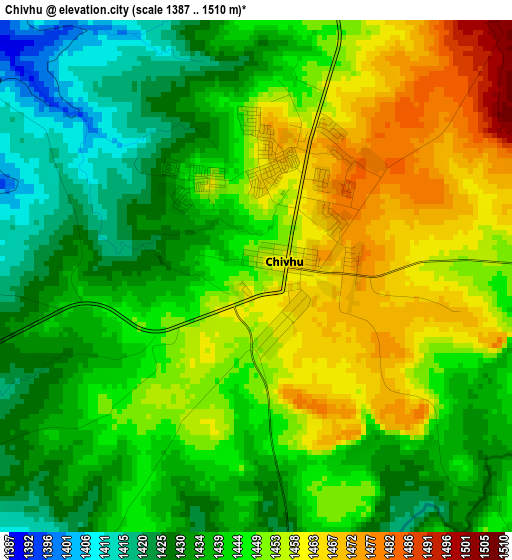
Below is the Elevation map of Chivhu, which displays elevation range with different colors. Scale of the first map is from 1387 to 1510 m (4551 to 4954 ft) with average elevation of 1444.9 meters (=4740 ft) [note 1]
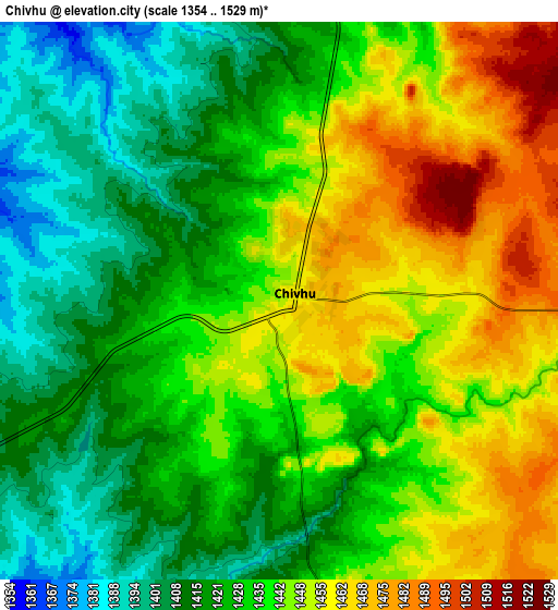
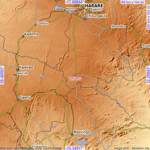
These maps also provides idea of topography and contour of this city, they are displayed at different zoom levels. More info about maps, scale and edge coordinates you can find below images.
| \ | Map #1 | Map #2 | Topo.Map |
| Scale [m] | 1387..1510 m | 1354..1529 m | × |
| Scale [ft] | 4551..4954 ft | 4442..5016 ft | × |
| Average | 1444.9 m = 4740 ft | 1434.9 m = 4708 ft | × |
| Width | 9.24 km = 5.7 mi | 18.48 km = 11.5 mi | 295.6 km = 183.7 mi |
| Height | 9.24 km = 5.7 mi | 18.48 km = 11.5 mi | 295.6 km = 183.7 mi |
| ↑Max Latitude | -18.979569° | -18.938008° | -17.68644° |
| Latitude at center | -19.02112° | -19.02112° | -19.02112° |
| ↓Min Latitude | -19.062661° | -19.104191° | -20.34517° |
| ← Min Longitude | 30.848235° | 30.804289° | 29.48593° |
| Longitude center | 30.89218° | 30.89218° | 30.89218° |
| →Max Longitude | 30.936125° | 30.980071° | 32.29843° |
Nearby cities:
Cities around Chivhu sort by population:
• Chitungwiza elevation 1435 m
113.8 km,  9°
9°
• Gweru 1412 m
122.6 km,  247°
247°
• Kwekwe 1203 m
113.7 km,  275°
275°
• Masvingo 1091 m
116.1 km,  183°
183°
• Marondera 1668 m
116.1 km,  36°
36°
• Redcliff 1232 m
116.6 km,  269°
269°
• Shurugwi 1483 m
117.7 km,  232°
232°
• Mashava 1046 m
120.8 km,  200°
200°
• Mvuma 1387 m
47.8 km, 233°
• Dorowa Mining Lease 916 m
90.3 km,  93°
93°
• Beatrice 1307 m
85.6 km,  356°
356°
• Lalapanzi 1500 m
82.6 km, 245°
Multilingual:
 En español:
Chivhu elevación 1450 m.
 En France:
Chivhu élévation 1450 m.


Sources and notes:
- [note 1] Map square and city borders are not equal. Map elevation data is calculated only from area inside that square.
- [src 1] Elevation data from geonames database provided with same terms of usage.
- [src 2] The elevation map of Chivhu is generated using elevation data from NASA's 3 arcsec (90m) resolution SRTM data.
- [src 3] Base (background) map © OpenStreetMap contributors tiles are generated by Geofabrik and OpenTopoMap.
Copyright & License:
This Chivhu Elevation Map is licensed under CC BY-SA. You may reuse any part from this page, if you give a proper credit by linking to this URL:
 More info on terms of use page.