Beaufort West elevation
Beaufort West (Western Cape, Central Karoo District Municipality), South Africa elevation is 849 meters and Beaufort West elevation in feet is 2785 ft above sea level [src 1]. Beaufort West is a seat of a second-order administrative division (feature code) with elevation that is 123 meters (404 ft) smaller than average city elevation in South Africa.
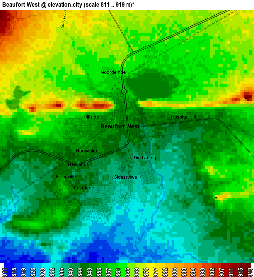
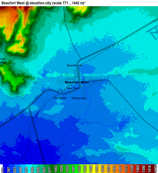
Below is the Elevation map of Beaufort West, which displays elevation range with different colors. Scale of the first map is from 811 to 919 m (2661 to 3015 ft) with average elevation of 853.3 meters (=2800 ft) [note 1]
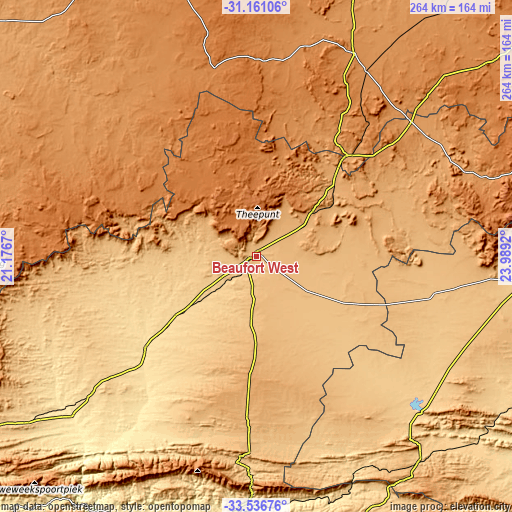
These maps also provides idea of topography and contour of this city, they are displayed at different zoom levels. More info about maps, scale and edge coordinates you can find below images.
| \ | Map #1 | Map #2 | Topo.Map |
| Scale [m] | 811..919 m | 771..1442 m | × |
| Scale [ft] | 2661..3015 ft | 2530..4731 ft | × |
| Average | 853.3 m = 2800 ft | 883.5 m = 2899 ft | × |
| Width | 8.26 km = 5.1 mi | 16.51 km = 10.3 mi | 264.2 km = 164.2 mi |
| Height | 8.26 km = 5.1 mi | 16.51 km = 10.3 mi | 264.2 km = 164.2 mi |
| ↑Max Latitude | -32.31958° | -32.282435° | -31.16106° |
| Latitude at center | -32.35671° | -32.35671° | -32.35671° |
| ↓Min Latitude | -32.393824° | -32.430924° | -33.53676° |
| ← Min Longitude | 22.539005° | 22.495059° | 21.1767° |
| Longitude center | 22.58295° | 22.58295° | 22.58295° |
| →Max Longitude | 22.626895° | 22.670841° | 23.9892° |
Nearby cities:
Cities around Beaufort West sort by population:
• Graaff-Reinet elevation 756 m
183.4 km,  86°
86°
• Oudtshoorn 319 m
142.8 km,  194°
194°
• Prince Albert 633 m
109.6 km,  208°
208°
• George 232 m
179 km,  183°
183°
• Ladismith 544 m
176.2 km,  224°
224°
• Willowmore 828 m
134.2 km,  140°
140°
• Carnarvon 1249 m
160.1 km,  344°
344°
• Zoar 504 m
165.3 km, 220°
• Calitzdorp 260 m
155.3 km, 213°
• De Rust 475 m
126.1 km, 182°
• Fraserburg 1262 m
112 km,  295°
295°
• Victoria West 1277 m
117.3 km,  25°
25°
Multilingual:
 En español:
Beaufort West elevación 849 m.
 En France:
Beaufort West élévation 849 m.
 Auf Deutsch:
Beaufort West höhe über dem Meeresspiegel ist 849 m.

Sources and notes:
- [note 1] Map square and city borders are not equal. Map elevation data is calculated only from area inside that square.
- [src 1] Elevation data from geonames database provided with same terms of usage.
- [src 2] The elevation map of Beaufort West is generated using elevation data from NASA's 3 arcsec (90m) resolution SRTM data.
- [src 3] Base (background) map © OpenStreetMap contributors tiles are generated by Geofabrik and OpenTopoMap.
Copyright & License:
This Beaufort West Elevation Map is licensed under CC BY-SA. You may reuse any part from this page, if you give a proper credit by linking to this URL:
 More info on terms of use page.