Graaff-Reinet elevation
Graaff-Reinet (Eastern Cape, Cacadu District Municipality), South Africa elevation is 756 meters and Graaff-Reinet elevation in feet is 2480 ft above sea level [src 1]. Graaff-Reinet is a seat of a third-order administrative division (feature code) with elevation that is 216 meters (709 ft) smaller than average city elevation in South Africa.
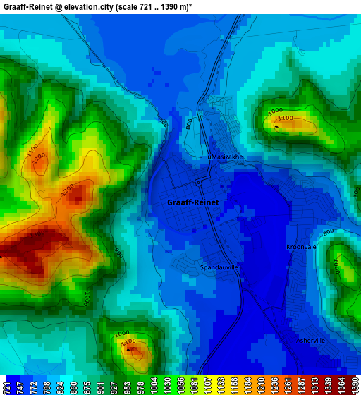
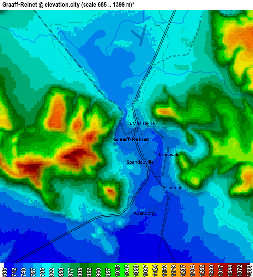
Below is the Elevation map of Graaff-Reinet, which displays elevation range with different colors. Scale of the first map is from 721 to 1390 m (2365 to 4560 ft) with average elevation of 877.4 meters (=2879 ft) [note 1]
These maps also provides idea of topography and contour of this city, they are displayed at different zoom levels. More info about maps, scale and edge coordinates you can find below images.
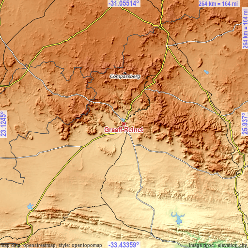
| \ | Map #1 | Map #2 | Topo.Map |
| Scale [m] | 721..1390 m | 685..1399 m | × |
| Scale [ft] | 2365..4560 ft | 2247..4590 ft | × |
| Average | 877.4 m = 2879 ft | 858.9 m = 2818 ft | × |
| Width | 8.26 km = 5.1 mi | 16.53 km = 10.3 mi | 264.5 km = 164.4 mi |
| Height | 8.26 km = 5.1 mi | 16.53 km = 10.3 mi | 264.5 km = 164.4 mi |
| ↑Max Latitude | -32.214978° | -32.17779° | -31.05514° |
| Latitude at center | -32.25215° | -32.25215° | -32.25215° |
| ↓Min Latitude | -32.289307° | -32.326449° | -33.43359° |
| ← Min Longitude | 24.486805° | 24.442859° | 23.1245° |
| Longitude center | 24.53075° | 24.53075° | 24.53075° |
| →Max Longitude | 24.574695° | 24.618641° | 25.937° |
Nearby cities:
Cities around Graaff-Reinet sort by population:
• Beaufort West elevation 849 m
183.4 km,  266°
266°
• Cradock 896 m
102.9 km,  84°
84°
• Middelburg 1253 m
95.6 km,  28°
28°
• Somerset East 748 m
112.1 km,  117°
117°
• Colesberg 1369 m
178.6 km,  17°
17°
• Adelaide 587 m
173.1 km,  107°
107°
• Kirkwood 113 m
153.3 km,  146°
146°
• Willowmore 828 m
151.2 km,  220°
220°
• Noupoort 1496 m
124.9 km, 18°
• Tarkastad 1300 m
165 km, 80°
• Victoria West 1277 m
163.7 km,  305°
305°
• Jansenville 420 m
78 km,  170°
170°
Multilingual:
 En español:
Graaff-Reinet elevación 756 m.
 En France:
Graaff-Reinet élévation 756 m.
 Auf Deutsch:
Graaff-Reinet höhe über dem Meeresspiegel ist 756 m.

Sources and notes:
- [note 1] Map square and city borders are not equal. Map elevation data is calculated only from area inside that square.
- [src 1] Elevation data from geonames database provided with same terms of usage.
- [src 2] The elevation map of Graaff-Reinet is generated using elevation data from NASA's 3 arcsec (90m) resolution SRTM data.
- [src 3] Base (background) map © OpenStreetMap contributors tiles are generated by Geofabrik and OpenTopoMap.
Copyright & License:
This Graaff-Reinet Elevation Map is licensed under CC BY-SA. You may reuse any part from this page, if you give a proper credit by linking to this URL:
 More info on terms of use page.