Bloemfontein elevation
Bloemfontein (Orange Free State, Mangaung Metropolitan Municipality), South Africa elevation is 1396 meters and Bloemfontein elevation in feet is 4580 ft above sea level [src 1]. Bloemfontein is a seat of a first-order administrative division (feature code) with elevation that is 424 meters (1391 ft) bigger than average city elevation in South Africa.
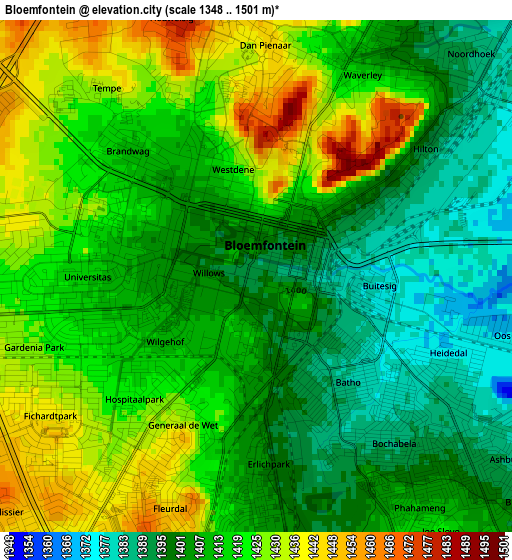
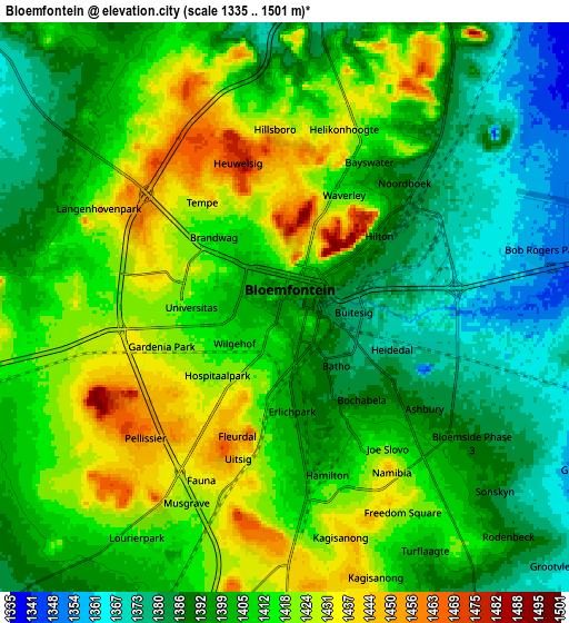
Below is the Elevation map of Bloemfontein, which displays elevation range with different colors. Scale of the first map is from 1348 to 1501 m (4423 to 4925 ft) with average elevation of 1412.9 meters (=4635 ft) [note 1]
These maps also provides idea of topography and contour of this city, they are displayed at different zoom levels. More info about maps, scale and edge coordinates you can find below images.
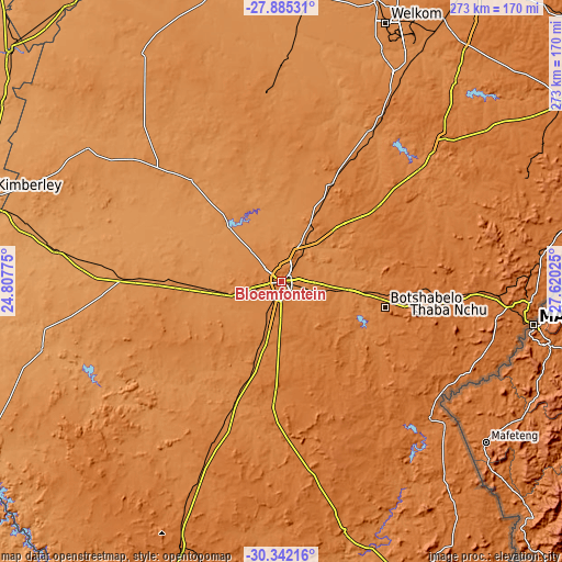
| \ | Map #1 | Map #2 | Topo.Map |
| Scale [m] | 1348..1501 m | 1335..1501 m | × |
| Scale [ft] | 4423..4925 ft | 4380..4925 ft | × |
| Average | 1412.9 m = 4635 ft | 1405.3 m = 4611 ft | × |
| Width | 8.54 km = 5.3 mi | 17.07 km = 10.6 mi | 273.2 km = 169.8 mi |
| Height | 8.54 km = 5.3 mi | 17.07 km = 10.6 mi | 273.2 km = 169.8 mi |
| ↑Max Latitude | -29.082673° | -29.044261° | -27.88531° |
| Latitude at center | -29.12107° | -29.12107° | -29.12107° |
| ↓Min Latitude | -29.159453° | -29.197822° | -30.34216° |
| ← Min Longitude | 26.170055° | 26.126109° | 24.80775° |
| Longitude center | 26.214° | 26.214° | 26.214° |
| →Max Longitude | 26.257945° | 26.301891° | 27.62025° |
Nearby cities:
Cities around Bloemfontein sort by population:
• Botshabelo elevation 1448 m
52.3 km,  108°
108°
• Thaba Nchu 1531 m
61.5 km,  99°
99°
• Theunissen 1406 m
92.1 km,  31°
31°
• Ladybrand 1588 m
121 km,  93°
93°
• Brandfort 1403 m
52.6 km, 27°
• Winburg 1438 m
102.5 km,  49°
49°
• Marquard 1518 m
128.8 km,  66°
66°
• Koffiefontein 1188 m
121.7 km,  254°
254°
• Boshof 1254 m
114.9 km,  304°
304°
• Trompsburg 1418 m
109.8 km,  202°
202°
• Bultfontein 1319 m
92.9 km,  356°
356°
• Dewetsdorp 1538 m
67.4 km,  139°
139°
Multilingual:
 En español:
Bloemfontein elevación 1396 m.
 En France:
Bloemfontein élévation 1396 m.
 Auf Deutsch:
Bloemfontein höhe über dem Meeresspiegel ist 1396 m.

Sources and notes:
- [note 1] Map square and city borders are not equal. Map elevation data is calculated only from area inside that square.
- [src 1] Elevation data from geonames database provided with same terms of usage.
- [src 2] The elevation map of Bloemfontein is generated using elevation data from NASA's 3 arcsec (90m) resolution SRTM data.
- [src 3] Base (background) map © OpenStreetMap contributors tiles are generated by Geofabrik and OpenTopoMap.
Copyright & License:
This Bloemfontein Elevation Map is licensed under CC BY-SA. You may reuse any part from this page, if you give a proper credit by linking to this URL:
 More info on terms of use page.