Ladybrand elevation
Ladybrand (Orange Free State, Thabo Mofutsanyana District Municipality), South Africa elevation is 1588 meters and Ladybrand elevation in feet is 5210 ft above sea level [src 1]. Ladybrand is a seat of a third-order administrative division (feature code) with elevation that is 616 meters (2021 ft) bigger than average city elevation in South Africa.
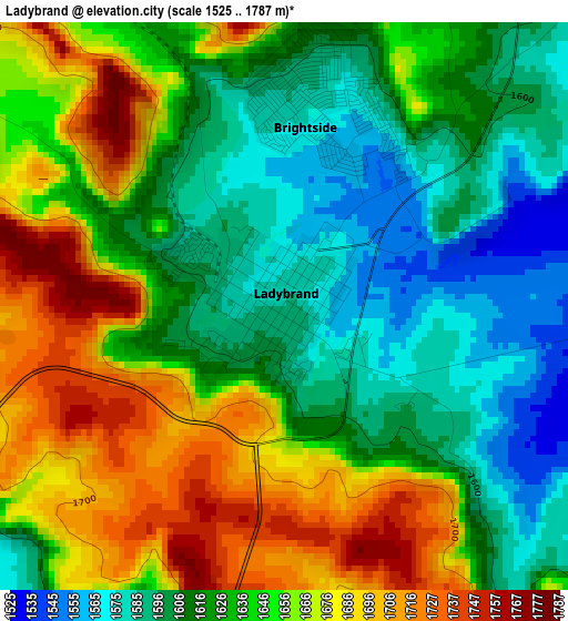
Below is the Elevation map of Ladybrand, which displays elevation range with different colors. Scale of the first map is from 1525 to 1787 m (5003 to 5863 ft) with average elevation of 1637.2 meters (=5371 ft) [note 1]
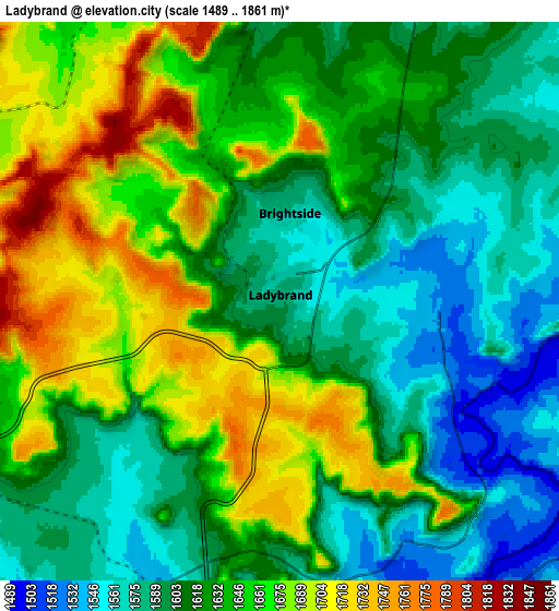
These maps also provides idea of topography and contour of this city, they are displayed at different zoom levels. More info about maps, scale and edge coordinates you can find below images.
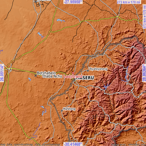
| \ | Map #1 | Map #2 | Topo.Map |
| Scale [m] | 1525..1787 m | 1489..1861 m | × |
| Scale [ft] | 5003..5863 ft | 4885..6106 ft | × |
| Average | 1637.2 m = 5371 ft | 1630.4 m = 5349 ft | × |
| Width | 8.53 km = 5.3 mi | 17.06 km = 10.6 mi | 273 km = 169.6 mi |
| Height | 8.53 km = 5.3 mi | 17.06 km = 10.6 mi | 273 km = 169.6 mi |
| ↑Max Latitude | -29.15611° | -29.117726° | -27.95958° |
| Latitude at center | -29.19448° | -29.19448° | -29.19448° |
| ↓Min Latitude | -29.232836° | -29.271177° | -30.41468° |
| ← Min Longitude | 27.413445° | 27.369499° | 26.05114° |
| Longitude center | 27.45739° | 27.45739° | 27.45739° |
| →Max Longitude | 27.501335° | 27.545281° | 28.86364° |
Nearby cities:
Cities around Ladybrand sort by population:
• Bloemfontein elevation 1396 m
121 km,  273°
273°
• Botshabelo 1448 m
71.4 km,  263°
263°
• Senekal 1431 m
98.6 km,  9°
9°
• Thaba Nchu 1531 m
60 km, 268°
• Theunissen 1406 m
114.1 km,  319°
319°
• Clocolan 1593 m
32.9 km,  18°
18°
• Brandfort 1403 m
111.6 km,  299°
299°
• Winburg 1438 m
87 km,  329°
329°
• Marquard 1518 m
59 km,  357°
357°
• Ventersburg 1435 m
127.2 km,  345°
345°
• Dewetsdorp 1538 m
88.1 km,  240°
240°
• Ficksburg 1598 m
54.2 km,  48°
48°
Multilingual:
 En español:
Ladybrand elevación 1588 m.
 En France:
Ladybrand élévation 1588 m.
 Auf Deutsch:
Ladybrand höhe über dem Meeresspiegel ist 1588 m.

Sources and notes:
- [note 1] Map square and city borders are not equal. Map elevation data is calculated only from area inside that square.
- [src 1] Elevation data from geonames database provided with same terms of usage.
- [src 2] The elevation map of Ladybrand is generated using elevation data from NASA's 3 arcsec (90m) resolution SRTM data.
- [src 3] Base (background) map © OpenStreetMap contributors tiles are generated by Geofabrik and OpenTopoMap.
Copyright & License:
This Ladybrand Elevation Map is licensed under CC BY-SA. You may reuse any part from this page, if you give a proper credit by linking to this URL:
 More info on terms of use page.