Theunissen elevation
Theunissen (Orange Free State, Lejweleputswa District Municipality), South Africa elevation is 1406 meters and Theunissen elevation in feet is 4613 ft above sea level [src 1]. Theunissen is a seat of a third-order administrative division (feature code) with elevation that is 434 meters (1424 ft) bigger than average city elevation in South Africa.
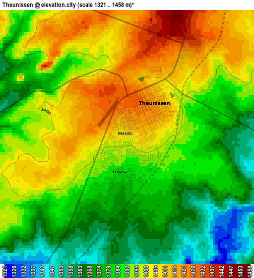
Below is the Elevation map of Theunissen, which displays elevation range with different colors. Scale of the first map is from 1321 to 1458 m (4334 to 4783 ft) with average elevation of 1389.9 meters (=4560 ft) [note 1]
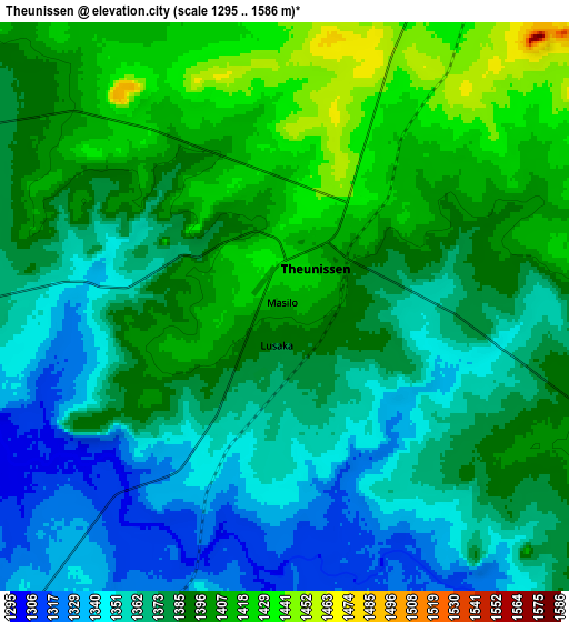
These maps also provides idea of topography and contour of this city, they are displayed at different zoom levels. More info about maps, scale and edge coordinates you can find below images.
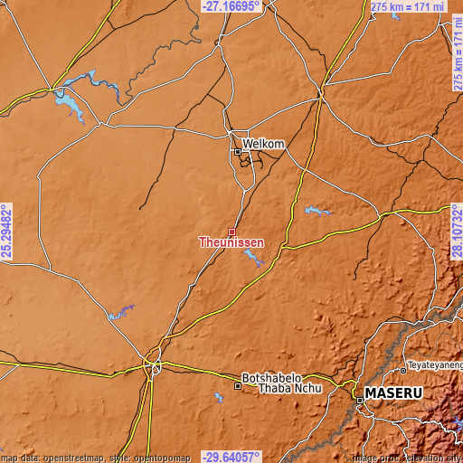
| \ | Map #1 | Map #2 | Topo.Map |
| Scale [m] | 1321..1458 m | 1295..1586 m | × |
| Scale [ft] | 4334..4783 ft | 4249..5203 ft | × |
| Average | 1389.9 m = 4560 ft | 1381.4 m = 4532 ft | × |
| Width | 8.6 km = 5.3 mi | 17.19 km = 10.7 mi | 275 km = 170.9 mi |
| Height | 8.6 km = 5.3 mi | 17.19 km = 10.7 mi | 275 km = 170.9 mi |
| ↑Max Latitude | -28.372321° | -28.333647° | -27.16695° |
| Latitude at center | -28.41098° | -28.41098° | -28.41098° |
| ↓Min Latitude | -28.449625° | -28.488257° | -29.64057° |
| ← Min Longitude | 26.657125° | 26.613179° | 25.29482° |
| Longitude center | 26.70107° | 26.70107° | 26.70107° |
| →Max Longitude | 26.745015° | 26.788961° | 28.10732° |
Nearby cities:
Cities around Theunissen sort by population:
• Welkom elevation 1376 m
48.3 km,  3°
3°
• Virginia 1326 m
37.8 km,  25°
25°
• Kutloanong 1326 m
64.4 km, 4°
• Wesselsbron 1315 m
70 km,  332°
332°
• Thaba Nchu 1531 m
89.8 km,  171°
171°
• Allanridge 1322 m
73.2 km,  355°
355°
• Hennenman 1396 m
57.8 km, 33°
• Brandfort 1403 m
39.9 km,  216°
216°
• Winburg 1438 m
32.4 km,  111°
111°
• Marquard 1518 m
76.6 km, 111°
• Ventersburg 1435 m
56 km,  49°
49°
• Bultfontein 1319 m
55.6 km,  284°
284°
Multilingual:
 En español:
Theunissen elevación 1406 m.
 En France:
Theunissen élévation 1406 m.
 Auf Deutsch:
Theunissen höhe über dem Meeresspiegel ist 1406 m.

Sources and notes:
- [note 1] Map square and city borders are not equal. Map elevation data is calculated only from area inside that square.
- [src 1] Elevation data from geonames database provided with same terms of usage.
- [src 2] The elevation map of Theunissen is generated using elevation data from NASA's 3 arcsec (90m) resolution SRTM data.
- [src 3] Base (background) map © OpenStreetMap contributors tiles are generated by Geofabrik and OpenTopoMap.
Copyright & License:
This Theunissen Elevation Map is licensed under CC BY-SA. You may reuse any part from this page, if you give a proper credit by linking to this URL:
 More info on terms of use page.