Thohoyandou elevation
Thohoyandou (Limpopo, Vhembe District Municipality), South Africa elevation is 724 meters and Thohoyandou elevation in feet is 2375 ft above sea level [src 1]. Thohoyandou is a seat of a second-order administrative division (feature code) with elevation that is 248 meters (814 ft) smaller than average city elevation in South Africa.
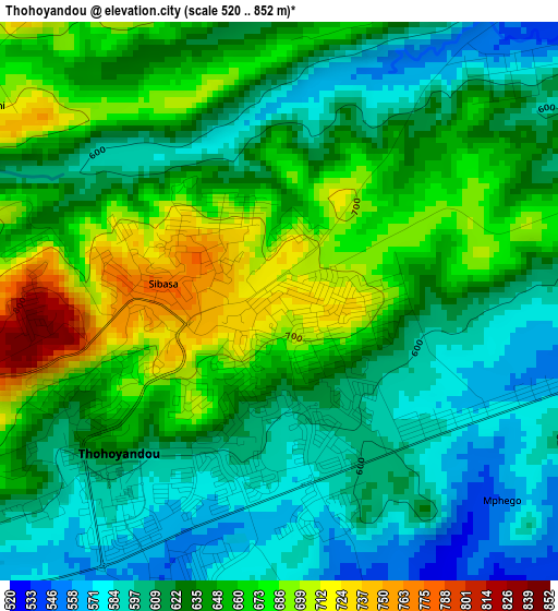
Below is the Elevation map of Thohoyandou, which displays elevation range with different colors. Scale of the first map is from 520 to 852 m (1706 to 2795 ft) with average elevation of 635.8 meters (=2086 ft) [note 1]
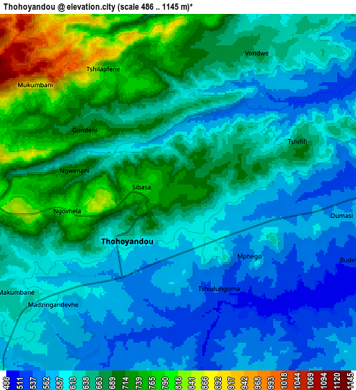
These maps also provides idea of topography and contour of this city, they are displayed at different zoom levels. More info about maps, scale and edge coordinates you can find below images.
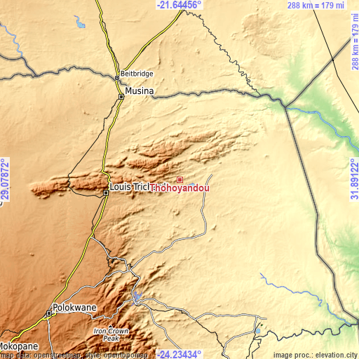
| \ | Map #1 | Map #2 | Topo.Map |
| Scale [m] | 520..852 m | 486..1145 m | × |
| Scale [ft] | 1706..2795 ft | 1594..3757 ft | × |
| Average | 635.8 m = 2086 ft | 642.2 m = 2107 ft | × |
| Width | 9 km = 5.6 mi | 18 km = 11.2 mi | 288 km = 179 mi |
| Height | 9 km = 5.6 mi | 18 km = 11.2 mi | 288 km = 179 mi |
| ↑Max Latitude | -22.905166° | -22.86468° | -21.64456° |
| Latitude at center | -22.94564° | -22.94564° | -22.94564° |
| ↓Min Latitude | -22.986102° | -23.026552° | -24.23434° |
| ← Min Longitude | 30.441025° | 30.397079° | 29.07872° |
| Longitude center | 30.48497° | 30.48497° | 30.48497° |
| →Max Longitude | 30.528915° | 30.572861° | 31.89122° |
Nearby cities:
Cities around Thohoyandou sort by population:
• Phalaborwa elevation 435 m
129.5 km,  148°
148°
• Louis Trichardt 956 m
60.5 km,  259°
259°
• Giyani 484 m
46.3 km, 148°
• Nkowakowa 584 m
106.7 km,  190°
190°
• Duiwelskloof 875 m
90.3 km,  202°
202°
• Tzaneen 719 m
104 km, 198°
• Ga-Kgapane 774 m
82.1 km, 199°
• Mankoeng 1389 m
126.1 km,  212°
212°
• Bochum 997 m
142.7 km,  254°
254°
• Dendron 1024 m
127.6 km, 248°
• Musina 540 m
80.5 km,  325°
325°
• Mutale 337 m
66.4 km,  37°
37°
Multilingual:
 En español:
Thohoyandou elevación 724 m.
 En France:
Thohoyandou élévation 724 m.
 Auf Deutsch:
Thohoyandou höhe über dem Meeresspiegel ist 724 m.

Sources and notes:
- [note 1] Map square and city borders are not equal. Map elevation data is calculated only from area inside that square.
- [src 1] Elevation data from geonames database provided with same terms of usage.
- [src 2] The elevation map of Thohoyandou is generated using elevation data from NASA's 3 arcsec (90m) resolution SRTM data.
- [src 3] Base (background) map © OpenStreetMap contributors tiles are generated by Geofabrik and OpenTopoMap.
Copyright & License:
This Thohoyandou Elevation Map is licensed under CC BY-SA. You may reuse any part from this page, if you give a proper credit by linking to this URL:
 More info on terms of use page.