Ulundi elevation
Ulundi (KwaZulu-Natal, Zululand District Municipality), South Africa elevation is 484 meters and Ulundi elevation in feet is 1588 ft above sea level [src 1]. Ulundi is a seat of a second-order administrative division (feature code) with elevation that is 488 meters (1601 ft) smaller than average city elevation in South Africa.
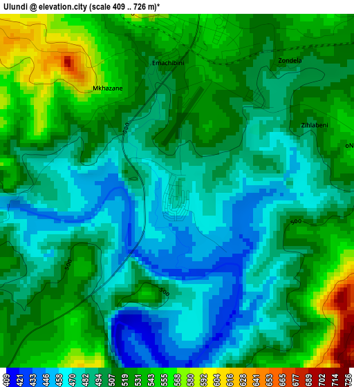
Below is the Elevation map of Ulundi, which displays elevation range with different colors. Scale of the first map is from 409 to 726 m (1342 to 2382 ft) with average elevation of 505.6 meters (=1659 ft) [note 1]
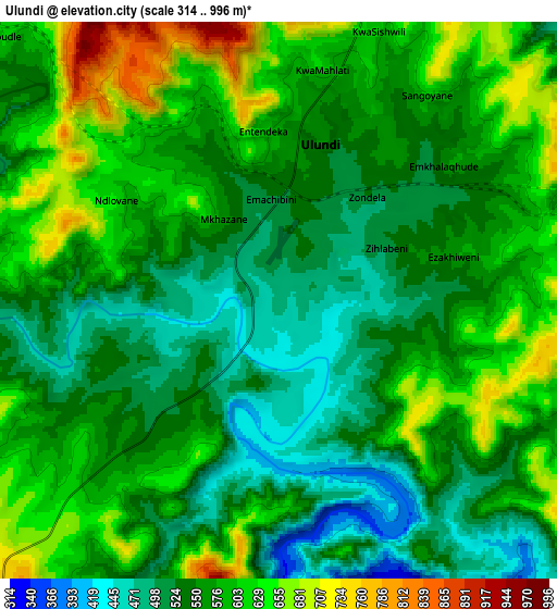
These maps also provides idea of topography and contour of this city, they are displayed at different zoom levels. More info about maps, scale and edge coordinates you can find below images.
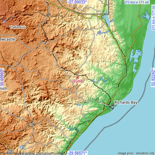
| \ | Map #1 | Map #2 | Topo.Map |
| Scale [m] | 409..726 m | 314..996 m | × |
| Scale [ft] | 1342..2382 ft | 1030..3268 ft | × |
| Average | 505.6 m = 1659 ft | 569.1 m = 1867 ft | × |
| Width | 8.6 km = 5.3 mi | 17.2 km = 10.7 mi | 275.2 km = 171 mi |
| Height | 8.6 km = 5.3 mi | 17.2 km = 10.7 mi | 275.2 km = 171 mi |
| ↑Max Latitude | -28.296543° | -28.257842° | -27.09033° |
| Latitude at center | -28.33523° | -28.33523° | -28.33523° |
| ↓Min Latitude | -28.373903° | -28.412562° | -29.56571° |
| ← Min Longitude | 31.372225° | 31.328279° | 30.00992° |
| Longitude center | 31.41617° | 31.41617° | 31.41617° |
| →Max Longitude | 31.460115° | 31.504061° | 32.82242° |
Nearby cities:
Cities around Ulundi sort by population:
• Richards Bay elevation 9 m
78.5 km,  129°
129°
• Vryheid 1170 m
87.8 km,  315°
315°
• eSikhaleni 15 m
76 km,  141°
141°
• Mondlo 1155 m
78.9 km,  299°
299°
• Empangeni 103 m
66.5 km, 135°
• Eshowe 539 m
61.5 km,  175°
175°
• Mtubatuba 66 m
75.8 km,  96°
96°
• KwaMbonambi 69 m
72 km,  113°
113°
• Nongoma 794 m
52.5 km,  25°
25°
• Hlabisa 516 m
49.9 km,  64°
64°
• Nkandla 1112 m
44.9 km,  225°
225°
• Melmoth 745 m
28 km, 183°
Multilingual:
 En español:
Ulundi elevación 484 m.
 En France:
Ulundi élévation 484 m.


Sources and notes:
- [note 1] Map square and city borders are not equal. Map elevation data is calculated only from area inside that square.
- [src 1] Elevation data from geonames database provided with same terms of usage.
- [src 2] The elevation map of Ulundi is generated using elevation data from NASA's 3 arcsec (90m) resolution SRTM data.
- [src 3] Base (background) map © OpenStreetMap contributors tiles are generated by Geofabrik and OpenTopoMap.
Copyright & License:
This Ulundi Elevation Map is licensed under CC BY-SA. You may reuse any part from this page, if you give a proper credit by linking to this URL:
 More info on terms of use page.