Vryheid elevation
Vryheid (KwaZulu-Natal, Zululand District Municipality), South Africa elevation is 1170 meters and Vryheid elevation in feet is 3839 ft above sea level [src 1]. Vryheid is a seat of a third-order administrative division (feature code) with elevation that is 198 meters (650 ft) bigger than average city elevation in South Africa.
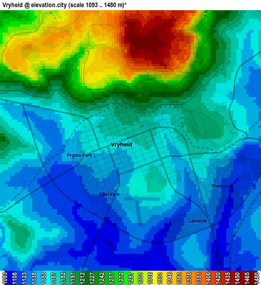
Below is the Elevation map of Vryheid, which displays elevation range with different colors. Scale of the first map is from 1093 to 1480 m (3586 to 4856 ft) with average elevation of 1193.9 meters (=3917 ft) [note 1]
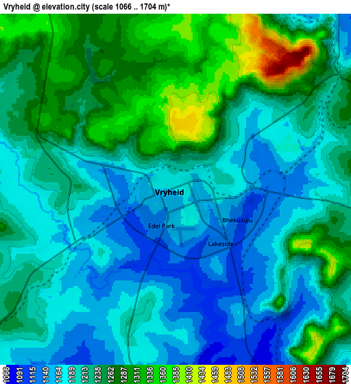
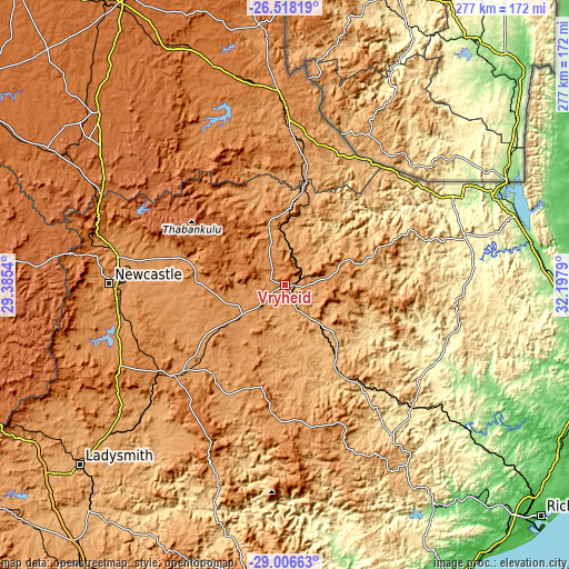
These maps also provides idea of topography and contour of this city, they are displayed at different zoom levels. More info about maps, scale and edge coordinates you can find below images.
| \ | Map #1 | Map #2 | Topo.Map |
| Scale [m] | 1093..1480 m | 1066..1704 m | × |
| Scale [ft] | 3586..4856 ft | 3497..5591 ft | × |
| Average | 1193.9 m = 3917 ft | 1223.4 m = 4014 ft | × |
| Width | 8.65 km = 5.4 mi | 17.29 km = 10.7 mi | 276.7 km = 171.9 mi |
| Height | 8.65 km = 5.4 mi | 17.29 km = 10.7 mi | 276.7 km = 171.9 mi |
| ↑Max Latitude | -27.730629° | -27.691724° | -26.51819° |
| Latitude at center | -27.76952° | -27.76952° | -27.76952° |
| ↓Min Latitude | -27.808397° | -27.84726° | -29.00663° |
| ← Min Longitude | 30.747705° | 30.703759° | 29.3854° |
| Longitude center | 30.79165° | 30.79165° | 30.79165° |
| →Max Longitude | 30.835595° | 30.879541° | 32.1979° |
Nearby cities:
Cities around Vryheid sort by population:
• Newcastle elevation 1195 m
84.6 km,  270°
270°
• Dundee 1260 m
70.4 km,  231°
231°
• Piet Retief 1251 m
84.8 km,  1°
1°
• Mondlo 1155 m
24.8 km,  197°
197°
• Driefontein 1345 m
90.1 km,  338°
338°
• Ulundi 484 m
87.8 km,  135°
135°
• Glencoe 1293 m
77.9 km, 234°
• Utrecht 1217 m
47.9 km,  284°
284°
• Pongola 305 m
92.4 km,  61°
61°
• Nongoma 794 m
85.6 km,  100°
100°
• Dannhauser 1359 m
77.2 km,  249°
249°
• Paulpietersburg 1126 m
38.5 km, 3°
Multilingual:
 En español:
Vryheid elevación 1170 m.
 En France:
Vryheid élévation 1170 m.
 Auf Deutsch:
Vryheid höhe über dem Meeresspiegel ist 1170 m.

Sources and notes:
- [note 1] Map square and city borders are not equal. Map elevation data is calculated only from area inside that square.
- [src 1] Elevation data from geonames database provided with same terms of usage.
- [src 2] The elevation map of Vryheid is generated using elevation data from NASA's 3 arcsec (90m) resolution SRTM data.
- [src 3] Base (background) map © OpenStreetMap contributors tiles are generated by Geofabrik and OpenTopoMap.
Copyright & License:
This Vryheid Elevation Map is licensed under CC BY-SA. You may reuse any part from this page, if you give a proper credit by linking to this URL:
 More info on terms of use page.