Empangeni elevation
Empangeni (KwaZulu-Natal, uThungulu District Municipality), South Africa elevation is 103 meters and Empangeni elevation in feet is 338 ft above sea level [src 1]. Empangeni is a populated place (feature code) with elevation that is 869 meters (2851 ft) smaller than average city elevation in South Africa.
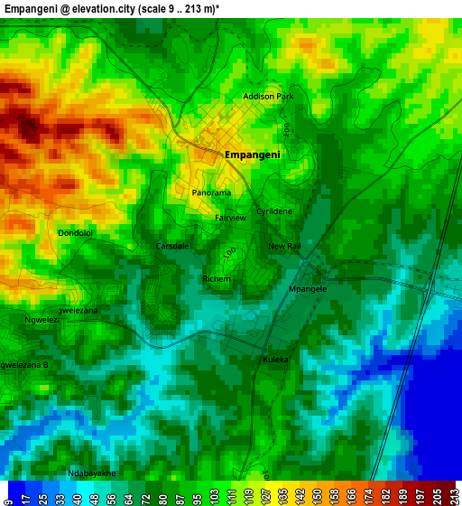
Below is the Elevation map of Empangeni, which displays elevation range with different colors. Scale of the first map is from 9 to 213 m (30 to 699 ft) with average elevation of 88.9 meters (=292 ft) [note 1]
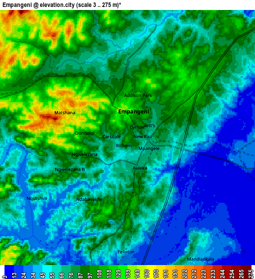
These maps also provides idea of topography and contour of this city, they are displayed at different zoom levels. More info about maps, scale and edge coordinates you can find below images.
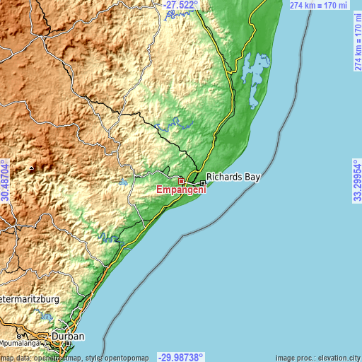
| \ | Map #1 | Map #2 | Topo.Map |
| Scale [m] | 9..213 m | 3..275 m | × |
| Scale [ft] | 30..699 ft | 10..902 ft | × |
| Average | 88.9 m = 292 ft | 75.6 m = 248 ft | × |
| Width | 8.57 km = 5.3 mi | 17.13 km = 10.6 mi | 274.1 km = 170.3 mi |
| Height | 8.57 km = 5.3 mi | 17.13 km = 10.6 mi | 274.1 km = 170.3 mi |
| ↑Max Latitude | -28.723439° | -28.684894° | -27.522° |
| Latitude at center | -28.76197° | -28.76197° | -28.76197° |
| ↓Min Latitude | -28.800487° | -28.838989° | -29.98738° |
| ← Min Longitude | 31.849345° | 31.805399° | 30.48704° |
| Longitude center | 31.89329° | 31.89329° | 31.89329° |
| →Max Longitude | 31.937235° | 31.981181° | 33.29954° |
Nearby cities:
Cities around Empangeni sort by population:
• Richards Bay elevation 9 m
14.3 km,  99°
99°
• KwaDukuza 111 m
86.1 km,  222°
222°
• eSikhaleni 15 m
12.1 km,  177°
177°
• Ulundi 484 m
66.5 km,  315°
315°
• Eshowe 539 m
43.5 km,  251°
251°
• Sundumbili 64 m
63.5 km,  229°
229°
• Nkandla 1112 m
79.8 km,  281°
281°
• Hlabisa 516 m
68.6 km,  358°
358°
• Mandeni 88 m
63.3 km, 227°
• Melmoth 745 m
52.1 km,  291°
291°
• Mtubatuba 66 m
47.7 km,  36°
36°
• KwaMbonambi 69 m
26.4 km,  46°
46°
Multilingual:
 En español:
Empangeni elevación 103 m.
 En France:
Empangeni élévation 103 m.
 Auf Deutsch:
Empangeni höhe über dem Meeresspiegel ist 103 m.

Sources and notes:
- [note 1] Map square and city borders are not equal. Map elevation data is calculated only from area inside that square.
- [src 1] Elevation data from geonames database provided with same terms of usage.
- [src 2] The elevation map of Empangeni is generated using elevation data from NASA's 3 arcsec (90m) resolution SRTM data.
- [src 3] Base (background) map © OpenStreetMap contributors tiles are generated by Geofabrik and OpenTopoMap.
Copyright & License:
This Empangeni Elevation Map is licensed under CC BY-SA. You may reuse any part from this page, if you give a proper credit by linking to this URL:
 More info on terms of use page.