Ţawr al Bāḩah elevation
Ţawr al Bāḩah (Laḩij, Tur Al Bahah), Yemen elevation is 664 meters and Ţawr al Bāḩah elevation in feet is 2178 ft above sea level [src 1]. Ţawr al Bāḩah is a seat of a second-order administrative division (feature code) with elevation that is 648 meters (2126 ft) smaller than average city elevation in Yemen.
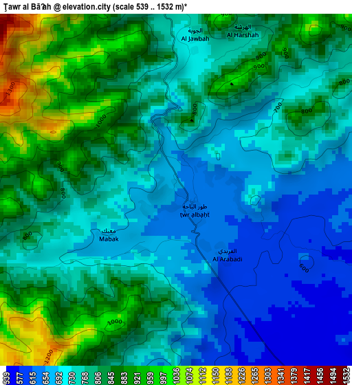
Below is the Elevation map of Ţawr al Bāḩah, which displays elevation range with different colors. Scale of the first map is from 539 to 1532 m (1768 to 5026 ft) with average elevation of 779.3 meters (=2557 ft) [note 1]
These maps also provides idea of topography and contour of this city, they are displayed at different zoom levels. More info about maps, scale and edge coordinates you can find below images.
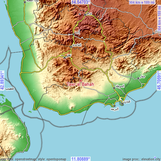
| \ | Map #1 | Topo.Map |
| Scale [m] | 539..1532 m | × |
| Scale [ft] | 1768..5026 ft | × |
| Average | 779.3 m = 2557 ft | × |
| Width | 9.51 km = 5.9 mi | 304.5 km = 189.2 mi |
| Height | 9.52 km = 5.9 mi | 304.5 km = 189.2 mi |
| ↑Max Latitude | 13.224574° | 14.54703° |
| Latitude at center | 13.18179° | 13.18179° |
| ↓Min Latitude | 13.138999° | 11.80889° |
| ← Min Longitude | 44.255715° | 42.89341° |
| Longitude center | 44.29966° | 44.29966° |
| →Max Longitude | 44.343605° | 45.70591° |
Nearby cities:
Cities around Ţawr al Bāḩah sort by population:
• Māwiyah elevation 1315 m
44.9 km,  6°
6°
• Al Misrākh 1354 m
43.3 km,  315°
315°
• Ash Shaţţ 237 m
42.9 km,  221°
221°
• Al Nashmah 1320 m
42.7 km,  302°
302°
• Ad Dimnah 1236 m
32.8 km,  337°
337°
• Kirsh 716 m
29 km,  45°
45°
• Al ‘Ayn 1467 m
27.9 km,  306°
306°
• Ḩawrah 1780 m
25.7 km, 319°
• At Turbah 1877 m
19.3 km,  280°
280°
• Aş Şalw 2304 m
18.6 km,  331°
331°
• Ḩayfān 1588 m
15.3 km,  352°
352°
• Ḩadādah 714 m
2.8 km,  255°
255°
Multilingual:
 En español:
Ţawr al Bāḩah elevación 664 m.
 En France:
Ţawr al Bāḩah élévation 664 m.
 Auf Deutsch:
Ţawr al Bāḩah höhe über dem Meeresspiegel ist 664 m.

Sources and notes:
- [note 1] Map square and city borders are not equal. Map elevation data is calculated only from area inside that square.
- [src 1] Elevation data from geonames database provided with same terms of usage.
- [src 2] The elevation map of Ţawr al Bāḩah is generated using elevation data from NASA's 3 arcsec (90m) resolution SRTM data.
- [src 3] Base (background) map © OpenStreetMap contributors tiles are generated by Geofabrik and OpenTopoMap.
Copyright & License:
This Ţawr al Bāḩah Elevation Map is licensed under CC BY-SA. You may reuse any part from this page, if you give a proper credit by linking to this URL:
 More info on terms of use page.