Kirsh elevation
Kirsh (Laḩij, Al Qabbaytah), Yemen elevation is 716 meters and Kirsh elevation in feet is 2349 ft above sea level [src 1]. Kirsh is a seat of a second-order administrative division (feature code) with elevation that is 596 meters (1955 ft) smaller than average city elevation in Yemen.
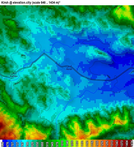
Below is the Elevation map of Kirsh, which displays elevation range with different colors. Scale of the first map is from 646 to 1434 m (2119 to 4705 ft) with average elevation of 831.6 meters (=2728 ft) [note 1]
These maps also provides idea of topography and contour of this city, they are displayed at different zoom levels. More info about maps, scale and edge coordinates you can find below images.
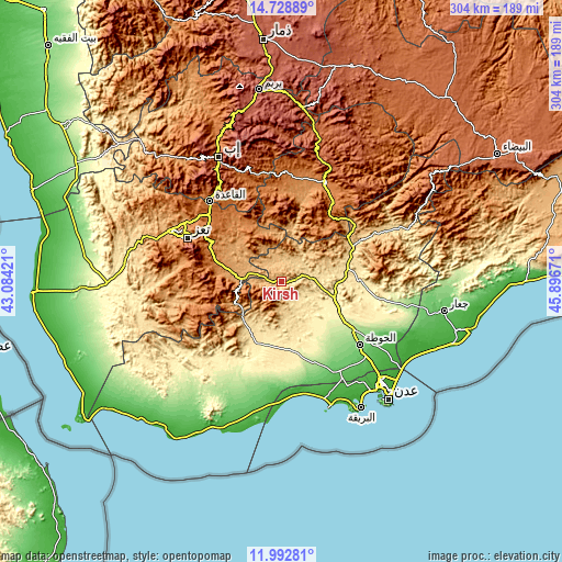
| \ | Map #1 | Topo.Map |
| Scale [m] | 646..1434 m | × |
| Scale [ft] | 2119..4705 ft | × |
| Average | 831.6 m = 2728 ft | × |
| Width | 9.51 km = 5.9 mi | 304.2 km = 189 mi |
| Height | 9.51 km = 5.9 mi | 304.3 km = 189.1 mi |
| ↑Max Latitude | 13.407481° | 14.72889° |
| Latitude at center | 13.36473° | 13.36473° |
| ↓Min Latitude | 13.321971° | 11.99281° |
| ← Min Longitude | 44.446515° | 43.08421° |
| Longitude center | 44.49046° | 44.49046° |
| →Max Longitude | 44.534405° | 45.89671° |
Nearby cities:
Cities around Kirsh sort by population:
• Al Musaymīr elevation 639 m
16.1 km,  56°
56°
• At Turbah 1877 m
43.1 km,  246°
246°
• Al Ḩabīlayn 630 m
42.6 km,  66°
66°
• Ḩawrah 1780 m
37.3 km,  268°
268°
• Dhī Jalāl 1219 m
37.2 km,  39°
39°
• Al Milāḩ 530 m
36.9 km,  79°
79°
• Ad Dimnah 1236 m
34.8 km,  286°
286°
• Ḩadādah 714 m
31.4 km,  227°
227°
• Aş Şalw 2304 m
29.8 km,  262°
262°
• Ţawr al Bāḩah 664 m
29 km, 225°
• Māwiyah 1315 m
28.8 km,  327°
327°
• Ḩayfān 1588 m
23.3 km, 257°
Multilingual:
 En español:
Kirsh elevación 716 m.
 En France:
Kirsh élévation 716 m.


Sources and notes:
- [note 1] Map square and city borders are not equal. Map elevation data is calculated only from area inside that square.
- [src 1] Elevation data from geonames database provided with same terms of usage.
- [src 2] The elevation map of Kirsh is generated using elevation data from NASA's 3 arcsec (90m) resolution SRTM data.
- [src 3] Base (background) map © OpenStreetMap contributors tiles are generated by Geofabrik and OpenTopoMap.
Copyright & License:
This Kirsh Elevation Map is licensed under CC BY-SA. You may reuse any part from this page, if you give a proper credit by linking to this URL:
 More info on terms of use page.