Ḩawrah elevation
Ḩawrah (Ta‘izz, Sama), Yemen elevation is 1780 meters and Ḩawrah elevation in feet is 5840 ft above sea level [src 1]. Ḩawrah is a seat of a second-order administrative division (feature code) with elevation that is 468 meters (1535 ft) bigger than average city elevation in Yemen.
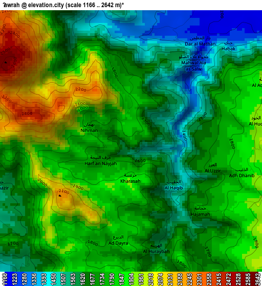
Below is the Elevation map of Ḩawrah, which displays elevation range with different colors. Scale of the first map is from 1166 to 2642 m (3825 to 8668 ft) with average elevation of 1753 meters (=5751 ft) [note 1]
These maps also provides idea of topography and contour of this city, they are displayed at different zoom levels. More info about maps, scale and edge coordinates you can find below images.
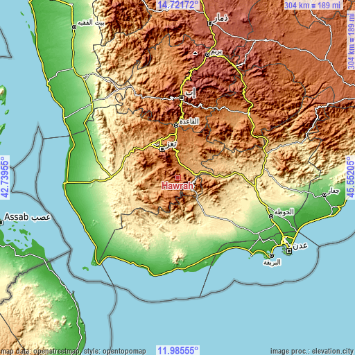
| \ | Map #1 | Topo.Map |
| Scale [m] | 1166..2642 m | × |
| Scale [ft] | 3825..8668 ft | × |
| Average | 1753 m = 5751 ft | × |
| Width | 9.51 km = 5.9 mi | 304.2 km = 189 mi |
| Height | 9.51 km = 5.9 mi | 304.3 km = 189.1 mi |
| ↑Max Latitude | 13.400263° | 14.72172° |
| Latitude at center | 13.35751° | 13.35751° |
| ↓Min Latitude | 13.31475° | 11.98555° |
| ← Min Longitude | 44.101855° | 42.73955° |
| Longitude center | 44.1458° | 44.1458° |
| →Max Longitude | 44.189745° | 45.55205° |
Nearby cities:
Cities around Ḩawrah sort by population:
• Dār an Nāşir elevation 2164 m
26.3 km,  327°
327°
• Ţawr al Bāḩah 664 m
25.7 km,  139°
139°
• Al Masālīyah 2208 m
25.3 km,  320°
320°
• Ḩadādah 714 m
24.6 km,  145°
145°
• Yufrus 1261 m
24.1 km,  296°
296°
• Al Nashmah 1320 m
19.5 km,  280°
280°
• Al Misrākh 1354 m
17.8 km,  310°
310°
• At Turbah 1877 m
16.3 km,  188°
188°
• Ḩayfān 1588 m
15.2 km,  106°
106°
• Ad Dimnah 1236 m
11.4 km,  19°
19°
• Aş Şalw 2304 m
8.3 km, 112°
• Al ‘Ayn 1467 m
6.6 km,  242°
242°
Multilingual:
 En español:
Ḩawrah elevación 1780 m.
 En France:
Ḩawrah élévation 1780 m.


Sources and notes:
- [note 1] Map square and city borders are not equal. Map elevation data is calculated only from area inside that square.
- [src 1] Elevation data from geonames database provided with same terms of usage.
- [src 2] The elevation map of Ḩawrah is generated using elevation data from NASA's 3 arcsec (90m) resolution SRTM data.
- [src 3] Base (background) map © OpenStreetMap contributors tiles are generated by Geofabrik and OpenTopoMap.
Copyright & License:
This Ḩawrah Elevation Map is licensed under CC BY-SA. You may reuse any part from this page, if you give a proper credit by linking to this URL:
 More info on terms of use page.