Al-Medy Village, قرية المدي elevation
Al-Medy Village, قرية المدي (Dhamār, Wusab Al Ali), Yemen elevation is 2063 meters and Al-Medy Village, قرية المدي elevation in feet is 6768 ft above sea level [src 1]. Al-Medy Village, قرية المدي is a farm village (feature code) with elevation that is 751 meters (2464 ft) bigger than average city elevation in Yemen.
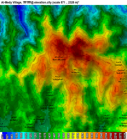
Below is the Elevation map of Al-Medy Village, قرية المدي, which displays elevation range with different colors. Scale of the first map is from 871 to 2328 m (2858 to 7638 ft) with average elevation of 1565 meters (=5135 ft) [note 1]
These maps also provides idea of topography and contour of this city, they are displayed at different zoom levels. More info about maps, scale and edge coordinates you can find below images.
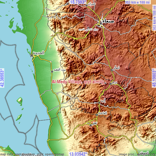
| \ | Map #1 | Topo.Map |
| Scale [m] | 871..2328 m | × |
| Scale [ft] | 2858..7638 ft | × |
| Average | 1565 m = 5135 ft | × |
| Width | 9.47 km = 5.9 mi | 302.9 km = 188.2 mi |
| Height | 9.47 km = 5.9 mi | 302.9 km = 188.2 mi |
| ↑Max Latitude | 14.44408° | 15.7593° |
| Latitude at center | 14.40152° | 14.40152° |
| ↓Min Latitude | 14.358952° | 13.03542° |
| ← Min Longitude | 43.747835° | 42.38553° |
| Longitude center | 43.79178° | 43.79178° |
| →Max Longitude | 43.835725° | 45.19803° |
Nearby cities:
Cities around Al-Medy Village, قرية المدي sort by population:
• Ḩazm al ‘Udayn elevation 2099 m
47.5 km,  151°
151°
• Riḩāb 1540 m
46.9 km,  114°
114°
• Z̧almah al ‘Ulyā 2145 m
46.6 km,  135°
135°
• Al Jum‘ah 2153 m
41.8 km,  26°
26°
• Al Jabīn 2427 m
39.5 km,  328°
328°
• Ḑubāh 2214 m
37.9 km,  74°
74°
• Aḑ Ḑil‘ 2026 m
30.2 km,  5°
5°
• Al Ḩadīyah 672 m
27.6 km,  300°
300°
• Sūq ar Rubū‘ 2032 m
27 km,  63°
63°
• Kusmah 2696 m
26.1 km,  320°
320°
• Al Aḩad 1240 m
22.7 km,  225°
225°
• Ad Dann 2480 m
8.6 km,  130°
130°
Multilingual:
 En español:
Al-Medy Village, قرية المدي elevación 2063 m.
 En France:
Al-Medy Village, قرية المدي élévation 2063 m.
 Auf Deutsch:
Al-Medy Village, قرية المدي höhe über dem Meeresspiegel ist 2063 m.
 На русском:
Al-Medy Village, قرية المدي высота над уровнем моря 2063 м
Sources and notes:
- [note 1] Map square and city borders are not equal. Map elevation data is calculated only from area inside that square.
- [src 1] Elevation data from geonames database provided with same terms of usage.
- [src 2] The elevation map of Al-Medy Village, قرية المدي is generated using elevation data from NASA's 3 arcsec (90m) resolution SRTM data.
- [src 3] Base (background) map © OpenStreetMap contributors tiles are generated by Geofabrik and OpenTopoMap.
Copyright & License:
This Al-Medy Village, قرية المدي Elevation Map is licensed under CC BY-SA. You may reuse any part from this page, if you give a proper credit by linking to this URL:
 More info on terms of use page.