Al Aḩad elevation
Al Aḩad (Dhamār, Wusab As Safil), Yemen elevation is 1240 meters and Al Aḩad elevation in feet is 4068 ft above sea level [src 1]. Al Aḩad is a seat of a second-order administrative division (feature code) with elevation that is 72 meters (236 ft) smaller than average city elevation in Yemen.
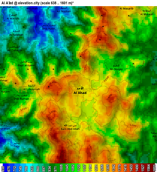
Below is the Elevation map of Al Aḩad, which displays elevation range with different colors. Scale of the first map is from 638 to 1601 m (2093 to 5253 ft) with average elevation of 1106.5 meters (=3630 ft) [note 1]
These maps also provides idea of topography and contour of this city, they are displayed at different zoom levels. More info about maps, scale and edge coordinates you can find below images.
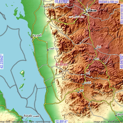
| \ | Map #1 | Topo.Map |
| Scale [m] | 638..1601 m | × |
| Scale [ft] | 2093..5253 ft | × |
| Average | 1106.5 m = 3630 ft | × |
| Width | 9.47 km = 5.9 mi | 303.1 km = 188.3 mi |
| Height | 9.47 km = 5.9 mi | 303.1 km = 188.3 mi |
| ↑Max Latitude | 14.300918° | 15.61702° |
| Latitude at center | 14.25833° | 14.25833° |
| ↓Min Latitude | 14.215734° | 12.8914° |
| ← Min Longitude | 43.597725° | 42.23542° |
| Longitude center | 43.64167° | 43.64167° |
| →Max Longitude | 43.685615° | 45.04792° |
Nearby cities:
Cities around Al Aḩad sort by population:
• Zabīd elevation 114 m
35.9 km,  258°
258°
• Bayt al Faqīh 151 m
44.6 km,  310°
310°
• Al-Medy Village, قرية المدي 2063 m
22.7 km,  45°
45°
• Ḩazm al ‘Udayn 2099 m
46.9 km,  123°
123°
• At Tuḩaytā’ 64 m
45.5 km, 259°
• Ḩays 211 m
40.1 km,  205°
205°
• Ar Ramādī 1173 m
36.9 km,  155°
155°
• Kusmah 2696 m
36 km,  359°
359°
• Markaz al Marīr 328 m
31.2 km,  189°
189°
• Al Ḩadīyah 672 m
30.8 km,  345°
345°
• Al Jarrāḩī 163 m
30.7 km,  242°
242°
• Ad Dann 2480 m
25 km,  65°
65°
Multilingual:
 En español:
Al Aḩad elevación 1240 m.
 En France:
Al Aḩad élévation 1240 m.
 Auf Deutsch:
Al Aḩad höhe über dem Meeresspiegel ist 1240 m.

Sources and notes:
- [note 1] Map square and city borders are not equal. Map elevation data is calculated only from area inside that square.
- [src 1] Elevation data from geonames database provided with same terms of usage.
- [src 2] The elevation map of Al Aḩad is generated using elevation data from NASA's 3 arcsec (90m) resolution SRTM data.
- [src 3] Base (background) map © OpenStreetMap contributors tiles are generated by Geofabrik and OpenTopoMap.
Copyright & License:
This Al Aḩad Elevation Map is licensed under CC BY-SA. You may reuse any part from this page, if you give a proper credit by linking to this URL:
 More info on terms of use page.