Sūq ar Rubū‘ elevation
Sūq ar Rubū‘ (Dhamār, Utmah), Yemen elevation is 2032 meters and Sūq ar Rubū‘ elevation in feet is 6667 ft above sea level [src 1]. Sūq ar Rubū‘ is a seat of a second-order administrative division (feature code) with elevation that is 720 meters (2362 ft) bigger than average city elevation in Yemen.
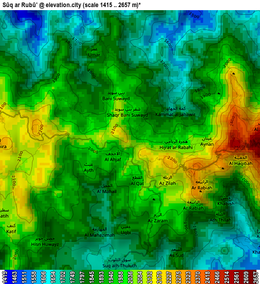
Below is the Elevation map of Sūq ar Rubū‘, which displays elevation range with different colors. Scale of the first map is from 1415 to 2657 m (4642 to 8717 ft) with average elevation of 1896.1 meters (=6221 ft) [note 1]
These maps also provides idea of topography and contour of this city, they are displayed at different zoom levels. More info about maps, scale and edge coordinates you can find below images.
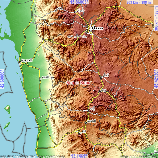
| \ | Map #1 | Topo.Map |
| Scale [m] | 1415..2657 m | × |
| Scale [ft] | 4642..8717 ft | × |
| Average | 1896.1 m = 6221 ft | × |
| Width | 9.46 km = 5.9 mi | 302.7 km = 188.1 mi |
| Height | 9.46 km = 5.9 mi | 302.7 km = 188.1 mi |
| ↑Max Latitude | 14.554089° | 15.86863° |
| Latitude at center | 14.51155° | 14.51155° |
| ↓Min Latitude | 14.469003° | 13.1461° |
| ← Min Longitude | 43.971165° | 42.60886° |
| Longitude center | 44.01511° | 44.01511° |
| →Max Longitude | 44.059055° | 45.42136° |
Nearby cities:
Cities around Sūq ar Rubū‘ sort by population:
• Dhamār elevation 2421 m
42.1 km,  85°
85°
• Yarīm 2626 m
45.7 km,  121°
121°
• Al-Medy Village, قرية المدي 2063 m
27 km,  243°
243°
• Ma‘bar 2329 m
43.4 km,  43°
43°
• Kusmah 2696 m
41.5 km,  280°
280°
• Riḩāb 1540 m
36.7 km,  149°
149°
• Ḑawrān ad Daydah 2395 m
32.6 km, 39°
• Aḑ Ḑil‘ 2026 m
27.7 km,  310°
310°
• Al Jum‘ah 2153 m
25.7 km,  347°
347°
• Ad Dann 2480 m
24.9 km,  224°
224°
• Ḩammām ‘Alī 1635 m
22.1 km, 40°
• Ḑubāh 2214 m
12.7 km,  100°
100°
Multilingual:
 En español:
Sūq ar Rubū‘ elevación 2032 m.
 En France:
Sūq ar Rubū‘ élévation 2032 m.
 Auf Deutsch:
Sūq ar Rubū‘ höhe über dem Meeresspiegel ist 2032 m.

Sources and notes:
- [note 1] Map square and city borders are not equal. Map elevation data is calculated only from area inside that square.
- [src 1] Elevation data from geonames database provided with same terms of usage.
- [src 2] The elevation map of Sūq ar Rubū‘ is generated using elevation data from NASA's 3 arcsec (90m) resolution SRTM data.
- [src 3] Base (background) map © OpenStreetMap contributors tiles are generated by Geofabrik and OpenTopoMap.
Copyright & License:
This Sūq ar Rubū‘ Elevation Map is licensed under CC BY-SA. You may reuse any part from this page, if you give a proper credit by linking to this URL:
 More info on terms of use page.