Llazicë elevation
Llazicë (Prizren, Komuna e Malisheves), Kosovo elevation is 635 meters and Llazicë elevation in feet is 2083 ft above sea level [src 1]. Llazicë is a populated place (feature code) with elevation that is 89 meters (292 ft) bigger than average city elevation in Kosovo.
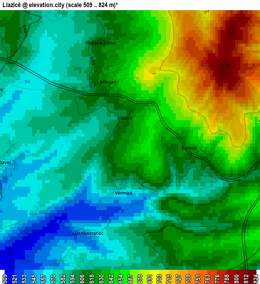
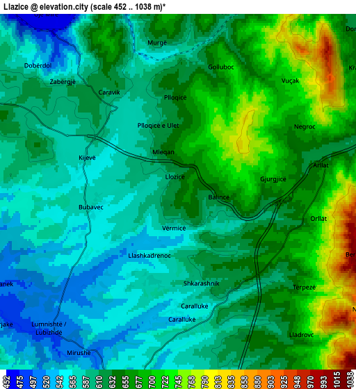
Below is the Elevation map of Llazicë, which displays elevation range with different colors. Scale of the first map is from 509 to 824 m (1670 to 2703 ft) with average elevation of 620 meters (=2034 ft) [note 1]
These maps also provides idea of topography and contour of this city, they are displayed at different zoom levels. More info about maps, scale and edge coordinates you can find below images.
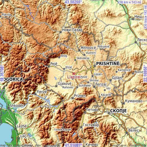
| \ | Map #1 | Map #2 | Topo.Map |
| Scale [m] | 509..824 m | 452..1038 m | × |
| Scale [ft] | 1670..2703 ft | 1483..3406 ft | × |
| Average | 620 m = 2034 ft | 627.5 m = 2059 ft | × |
| Width | 7.2 km = 4.5 mi | 14.4 km = 8.9 mi | 230.4 km = 143.2 mi |
| Height | 7.2 km = 4.5 mi | 14.4 km = 8.9 mi | 230.3 km = 143.1 mi |
| ↑Max Latitude | 42.587643° | 42.619989° | 43.58255° |
| Latitude at center | 42.55528° | 42.55528° | 42.55528° |
| ↓Min Latitude | 42.5229° | 42.490504° | 41.51081° |
| ← Min Longitude | 20.719385° | 20.675439° | 19.35708° |
| Longitude center | 20.76333° | 20.76333° | 20.76333° |
| →Max Longitude | 20.807275° | 20.851221° | 22.16958° |
Nearby cities:
Cities around Llazicë sort by population:
• Suva Reka elevation 387 m
22.4 km,  166°
166°
• Glogovac 584 m
13.4 km,  52°
52°
• Orahovac 393 m
19.5 km,  207°
207°
• Klina 404 m
16.9 km,  295°
295°
• Mamuša 333 m
25.1 km,  186°
186°
• Srbica 612 m
21.4 km,  5°
5°
• Mališevo 529 m
8.2 km, 190°
• Peqan 432 m
19.7 km, 165°
• Pagaruša 539 m
15.1 km, 186°
• Kosuriq 419 m
24.5 km,  273°
273°
• Nishor 624 m
14.9 km, 167°
• Glanica 547 m
24.6 km,  91°
91°
Multilingual:
 En español:
Llazicë elevación 635 m.
 En France:
Llazicë élévation 635 m.


Sources and notes:
- [note 1] Map square and city borders are not equal. Map elevation data is calculated only from area inside that square.
- [src 1] Elevation data from geonames database provided with same terms of usage.
- [src 2] The elevation map of Llazicë is generated using elevation data from NASA's 3 arcsec (90m) resolution SRTM data.
- [src 3] Base (background) map © OpenStreetMap contributors tiles are generated by Geofabrik and OpenTopoMap.
Copyright & License:
This Llazicë Elevation Map is licensed under CC BY-SA. You may reuse any part from this page, if you give a proper credit by linking to this URL:
 More info on terms of use page.