Hòa Bình elevation
Hòa Bình, Vietnam elevation is 31 meters and Hòa Bình elevation in feet is 102 ft above sea level [src 1]. Hòa Bình is a seat of a first-order administrative division (feature code) with elevation that is 97 meters (318 ft) smaller than average city elevation in Vietnam.
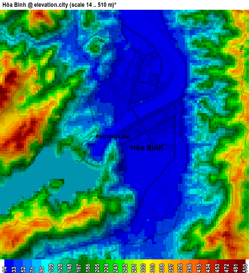
Below is the Elevation map of Hòa Bình, which displays elevation range with different colors. Scale of the first map is from 14 to 510 m (46 to 1673 ft) with average elevation of 145.1 meters (=476 ft) [note 1]
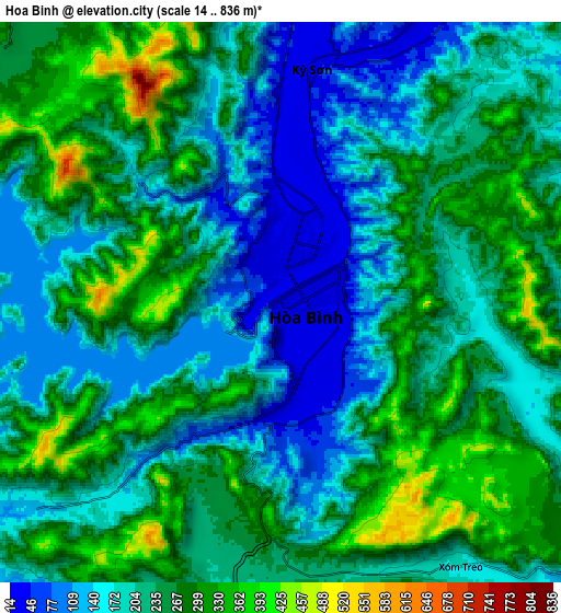
These maps also provides idea of topography and contour of this city, they are displayed at different zoom levels. More info about maps, scale and edge coordinates you can find below images.
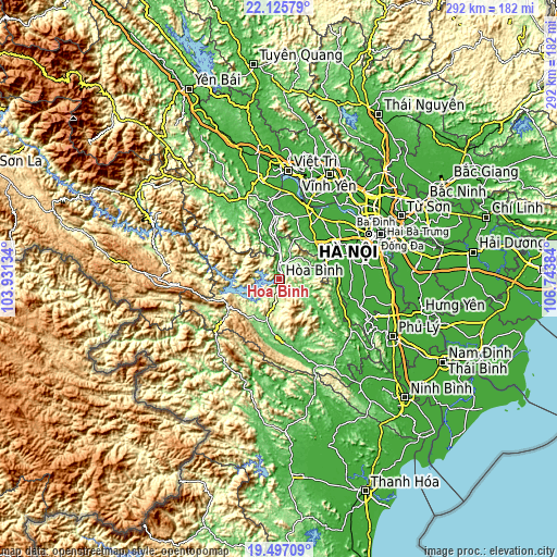
| \ | Map #1 | Map #2 | Topo.Map |
| Scale [m] | 14..510 m | 14..836 m | × |
| Scale [ft] | 46..1673 ft | 46..2743 ft | × |
| Average | 145.1 m = 476 ft | 223.5 m = 733 ft | × |
| Width | 9.13 km = 5.7 mi | 18.27 km = 11.4 mi | 292.3 km = 181.6 mi |
| Height | 9.13 km = 5.7 mi | 18.27 km = 11.4 mi | 292.3 km = 181.6 mi |
| ↑Max Latitude | 20.858241° | 20.899301° | 22.12579° |
| Latitude at center | 20.81717° | 20.81717° | 20.81717° |
| ↓Min Latitude | 20.776088° | 20.734995° | 19.49709° |
| ← Min Longitude | 105.293645° | 105.249699° | 103.93134° |
| Longitude center | 105.33759° | 105.33759° | 105.33759° |
| →Max Longitude | 105.381535° | 105.425481° | 106.74384° |
Nearby cities:
Cities around Hòa Bình sort by population:
• Sơn Tây elevation 16 m
40 km,  26°
26°
• Thanh Thủy 23 m
40.2 km,  352°
352°
• Chúc Sơn 16 m
39.6 km,  72°
72°
• Phúc Thọ 17 m
38.5 km, 34°
• Quốc Oai 12 m
36.9 km,  58°
58°
• Liên Quan 9 m
36.6 km,  43°
43°
• Bo 67 m
26.2 km,  127°
127°
• Mường Khến 114 m
23.3 km,  195°
195°
• Lương Sơn 23 m
20.5 km, 72°
• Cao Phong 205 m
12.7 km,  188°
188°
• Đà Bắc 280 m
10.9 km,  307°
307°
• Kỳ Sơn 28 m
7.9 km,  11°
11°
Multilingual:
 En español:
Hòa Bình elevación 31 m.
 En France:
Hòa Bình élévation 31 m.


Sources and notes:
- [note 1] Map square and city borders are not equal. Map elevation data is calculated only from area inside that square.
- [src 1] Elevation data from geonames database provided with same terms of usage.
- [src 2] The elevation map of Hòa Bình is generated using elevation data from NASA's 3 arcsec (90m) resolution SRTM data.
- [src 3] Base (background) map © OpenStreetMap contributors tiles are generated by Geofabrik and OpenTopoMap.
Copyright & License:
This Hòa Bình Elevation Map is licensed under CC BY-SA. You may reuse any part from this page, if you give a proper credit by linking to this URL:
 More info on terms of use page.