Lương Sơn elevation
Lương Sơn (Hòa Bình), Vietnam elevation is 23 meters and Lương Sơn elevation in feet is 75 ft above sea level [src 1]. Lương Sơn is a seat of a second-order administrative division (feature code) with elevation that is 105 meters (344 ft) smaller than average city elevation in Vietnam.
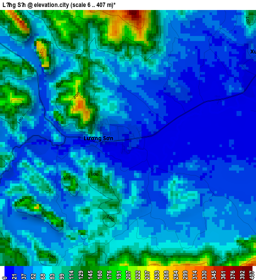
Below is the Elevation map of Lương Sơn, which displays elevation range with different colors. Scale of the first map is from 6 to 407 m (20 to 1335 ft) with average elevation of 71.5 meters (=235 ft) [note 1]
These maps also provides idea of topography and contour of this city, they are displayed at different zoom levels. More info about maps, scale and edge coordinates you can find below images.
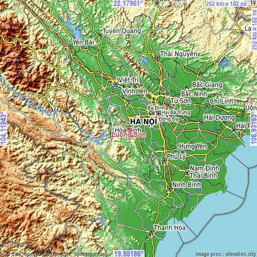
| \ | Map #1 | Topo.Map |
| Scale [m] | 6..407 m | × |
| Scale [ft] | 20..1335 ft | × |
| Average | 71.5 m = 235 ft | × |
| Width | 9.13 km = 5.7 mi | 292.2 km = 181.6 mi |
| Height | 9.13 km = 5.7 mi | 292.2 km = 181.6 mi |
| ↑Max Latitude | 20.912536° | 22.17961° |
| Latitude at center | 20.87148° | 20.87148° |
| ↓Min Latitude | 20.830413° | 19.55186° |
| ← Min Longitude | 105.481735° | 104.11943° |
| Longitude center | 105.52568° | 105.52568° |
| →Max Longitude | 105.569625° | 106.93193° |
Nearby cities:
Cities around Lương Sơn sort by population:
• Hòa Bình elevation 31 m
20.5 km,  252°
252°
• Hà Đông 13 m
28.5 km,  67°
67°
• Cao Phong 205 m
28.3 km,  228°
228°
• Đà Bắc 280 m
28.2 km,  271°
271°
• Phùng 16 m
27.9 km,  29°
29°
• Phúc Thọ 17 m
25.9 km,  4°
4°
• Kim Bài 10 m
25.4 km,  94°
94°
• Bo 67 m
22.1 km,  177°
177°
• Liên Quan 9 m
21.4 km,  15°
15°
• Chúc Sơn 16 m
19.2 km, 72°
• Kỳ Sơn 28 m
18.1 km,  275°
275°
• Quốc Oai 12 m
17.8 km,  42°
42°
Multilingual:
 En español:
Lương Sơn elevación 23 m.
 En France:
Lương Sơn élévation 23 m.
 Auf Deutsch:
Lương Sơn höhe über dem Meeresspiegel ist 23 m.

Sources and notes:
- [note 1] Map square and city borders are not equal. Map elevation data is calculated only from area inside that square.
- [src 1] Elevation data from geonames database provided with same terms of usage.
- [src 2] The elevation map of Lương Sơn is generated using elevation data from NASA's 3 arcsec (90m) resolution SRTM data.
- [src 3] Base (background) map © OpenStreetMap contributors tiles are generated by Geofabrik and OpenTopoMap.
Copyright & License:
This Lương Sơn Elevation Map is licensed under CC BY-SA. You may reuse any part from this page, if you give a proper credit by linking to this URL:
 More info on terms of use page.