Bo elevation
Bo (Hòa Bình), Vietnam elevation is 67 meters and Bo elevation in feet is 220 ft above sea level [src 1]. Bo is a seat of a second-order administrative division (feature code) with elevation that is 61 meters (200 ft) smaller than average city elevation in Vietnam.
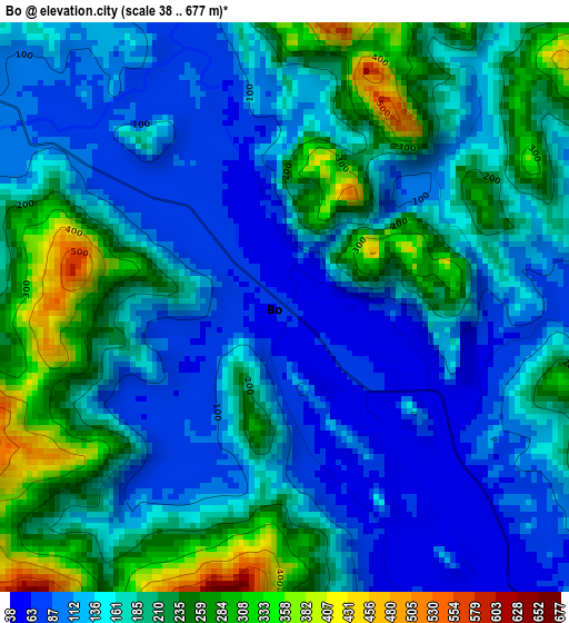
Below is the Elevation map of Bo, which displays elevation range with different colors. Scale of the first map is from 38 to 677 m (125 to 2221 ft) with average elevation of 167.9 meters (=551 ft) [note 1]
These maps also provides idea of topography and contour of this city, they are displayed at different zoom levels. More info about maps, scale and edge coordinates you can find below images.
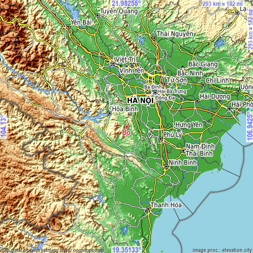
| \ | Map #1 | Topo.Map |
| Scale [m] | 38..677 m | × |
| Scale [ft] | 125..2221 ft | × |
| Average | 167.9 m = 551 ft | × |
| Width | 9.14 km = 5.7 mi | 292.6 km = 181.8 mi |
| Height | 9.14 km = 5.7 mi | 292.6 km = 181.8 mi |
| ↑Max Latitude | 20.71375° | 21.98255° |
| Latitude at center | 20.67264° | 20.67264° |
| ↓Min Latitude | 20.631519° | 19.35133° |
| ← Min Longitude | 105.492305° | 104.13° |
| Longitude center | 105.53625° | 105.53625° |
| →Max Longitude | 105.580195° | 106.9425° |
Nearby cities:
Cities around Bo sort by population:
• Hòa Bình elevation 31 m
26.2 km,  307°
307°
• Chúc Sơn 16 m
32.8 km,  31°
31°
• Chi Nê 15 m
32.3 km,  128°
128°
• Hàng Trạm 49 m
32.2 km,  163°
163°
• Kim Bài 10 m
31.5 km,  50°
50°
• Kỳ Sơn 28 m
30.5 km,  321°
321°
• Mường Khến 114 m
27.5 km,  256°
256°
• Vân Đình 11 m
25.5 km,  74°
74°
• Vụ Bản 47 m
25.1 km,  202°
202°
• Cao Phong 205 m
22.7 km,  278°
278°
• Lương Sơn 23 m
22.1 km,  357°
357°
• Đại Nghĩa 10 m
21.7 km,  85°
85°


Sources and notes:
- [note 1] Map square and city borders are not equal. Map elevation data is calculated only from area inside that square.
- [src 1] Elevation data from geonames database provided with same terms of usage.
- [src 2] The elevation map of Bo is generated using elevation data from NASA's 3 arcsec (90m) resolution SRTM data.
- [src 3] Base (background) map © OpenStreetMap contributors tiles are generated by Geofabrik and OpenTopoMap.
Copyright & License:
This Bo Elevation Map is licensed under CC BY-SA. You may reuse any part from this page, if you give a proper credit by linking to this URL:
 More info on terms of use page.