Hát Lót elevation
Hát Lót (Sơn La), Vietnam elevation is 541 meters and Hát Lót elevation in feet is 1775 ft above sea level [src 1]. Hát Lót is a seat of a second-order administrative division (feature code) with elevation that is 413 meters (1355 ft) bigger than average city elevation in Vietnam.
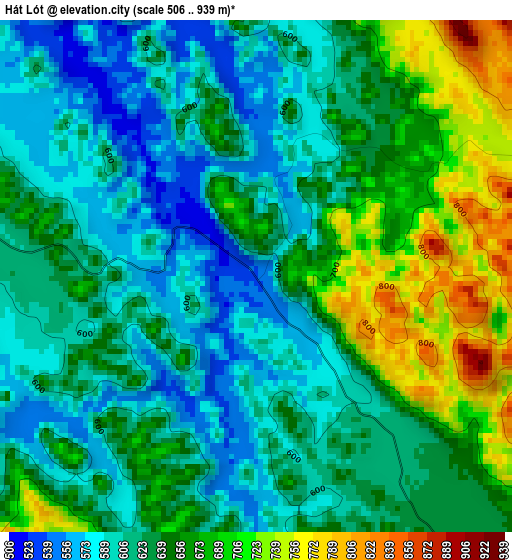
Below is the Elevation map of Hát Lót, which displays elevation range with different colors. Scale of the first map is from 506 to 939 m (1660 to 3081 ft) with average elevation of 636 meters (=2087 ft) [note 1]
These maps also provides idea of topography and contour of this city, they are displayed at different zoom levels. More info about maps, scale and edge coordinates you can find below images.
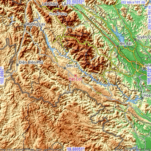
| \ | Map #1 | Topo.Map |
| Scale [m] | 506..939 m | × |
| Scale [ft] | 1660..3081 ft | × |
| Average | 636 m = 2087 ft | × |
| Width | 9.11 km = 5.7 mi | 291.5 km = 181.1 mi |
| Height | 9.11 km = 5.7 mi | 291.6 km = 181.2 mi |
| ↑Max Latitude | 21.238296° | 22.50252° |
| Latitude at center | 21.19733° | 21.19733° |
| ↓Min Latitude | 21.156352° | 19.88051° |
| ← Min Longitude | 104.062005° | 102.6997° |
| Longitude center | 104.10595° | 104.10595° |
| →Max Longitude | 104.149895° | 105.5122° |
Nearby cities:
Cities around Hát Lót sort by population:
• Sơn La elevation 608 m
24.1 km,  306°
306°
• Thị Trấn Tuần Giáo 568 m
83.2 km,  301°
301°
• Mù Cang Chải 964 m
72.7 km,  358°
358°
• Mộc Châu 814 m
65.9 km,  125°
125°
• Sơn Thịnh 316 m
64.9 km,  51°
51°
• Phù Yên 181 m
56.3 km,  82°
82°
• Thị Trấn Thuận Châu 594 m
50.7 km, 301°
• Thị Trấn Trạm Tấu 691 m
41.2 km,  43°
43°
• Sông Mã 336 m
40.4 km,  246°
246°
• Ít Ong 206 m
36.5 km,  347°
347°
• Bắc Yên 656 m
34.3 km, 80°
• Yên Châu 294 m
26.3 km, 129°
Multilingual:
 En español:
Hát Lót elevación 541 m.
 En France:
Hát Lót élévation 541 m.


Sources and notes:
- [note 1] Map square and city borders are not equal. Map elevation data is calculated only from area inside that square.
- [src 1] Elevation data from geonames database provided with same terms of usage.
- [src 2] The elevation map of Hát Lót is generated using elevation data from NASA's 3 arcsec (90m) resolution SRTM data.
- [src 3] Base (background) map © OpenStreetMap contributors tiles are generated by Geofabrik and OpenTopoMap.
Copyright & License:
This Hát Lót Elevation Map is licensed under CC BY-SA. You may reuse any part from this page, if you give a proper credit by linking to this URL:
 More info on terms of use page.