Sơn Thịnh elevation
Sơn Thịnh (Yên Bái), Vietnam elevation is 316 meters and Sơn Thịnh elevation in feet is 1037 ft above sea level [src 1]. Sơn Thịnh is a seat of a second-order administrative division (feature code) with elevation that is 188 meters (617 ft) bigger than average city elevation in Vietnam.
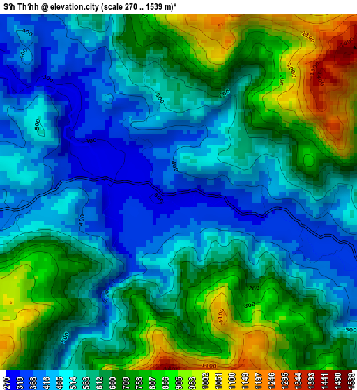
Below is the Elevation map of Sơn Thịnh, which displays elevation range with different colors. Scale of the first map is from 270 to 1539 m (886 to 5049 ft) with average elevation of 618.5 meters (=2029 ft) [note 1]
These maps also provides idea of topography and contour of this city, they are displayed at different zoom levels. More info about maps, scale and edge coordinates you can find below images.
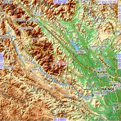
| \ | Map #1 | Topo.Map |
| Scale [m] | 270..1539 m | × |
| Scale [ft] | 886..5049 ft | × |
| Average | 618.5 m = 2029 ft | × |
| Width | 9.09 km = 5.6 mi | 290.8 km = 180.7 mi |
| Height | 9.09 km = 5.6 mi | 290.8 km = 180.7 mi |
| ↑Max Latitude | 21.603384° | 22.86436° |
| Latitude at center | 21.56252° | 21.56252° |
| ↓Min Latitude | 21.521644° | 20.24888° |
| ← Min Longitude | 104.550855° | 103.18855° |
| Longitude center | 104.5948° | 104.5948° |
| →Max Longitude | 104.638745° | 106.00105° |
Nearby cities:
Cities around Sơn Thịnh sort by population:
• Yên Bái elevation 45 m
37.3 km,  61°
61°
• Mù Cang Chải 964 m
61.3 km,  301°
301°
• Đoan Hùng 23 m
61.3 km,  83°
83°
• Ít Ong 206 m
58.9 km,  265°
265°
• Sông Thao 44 m
57.9 km,  105°
105°
• Thanh Ba 47 m
56.9 km,  97°
97°
• Yên Lập 70 m
53.5 km,  116°
116°
• Hạ Hòa 30 m
42.4 km,  89°
89°
• Bắc Yên 656 m
39 km,  205°
205°
• Phù Yên 181 m
33.7 km,  171°
171°
• Cổ Phúc 41 m
32.3 km,  48°
48°
• Thị Trấn Trạm Tấu 691 m
24.7 km,  244°
244°
Multilingual:
 En español:
Sơn Thịnh elevación 316 m.
 En France:
Sơn Thịnh élévation 316 m.
 Auf Deutsch:
Sơn Thịnh höhe über dem Meeresspiegel ist 316 m.

Sources and notes:
- [note 1] Map square and city borders are not equal. Map elevation data is calculated only from area inside that square.
- [src 1] Elevation data from geonames database provided with same terms of usage.
- [src 2] The elevation map of Sơn Thịnh is generated using elevation data from NASA's 3 arcsec (90m) resolution SRTM data.
- [src 3] Base (background) map © OpenStreetMap contributors tiles are generated by Geofabrik and OpenTopoMap.
Copyright & License:
This Sơn Thịnh Elevation Map is licensed under CC BY-SA. You may reuse any part from this page, if you give a proper credit by linking to this URL:
 More info on terms of use page.